1990s Maps of Earlham, Iowa
Explore 2 historic maps of Earlham from the 1990s. These maps offer a rare glimpse into what life looked like during the 1990s — showing old roads, neighborhoods, homes, and landmarks that have changed or disappeared over time.
Whether you're researching your family's past, planning a metal detecting trip, or studying how Earlham's landscape evolved across the 1990s, these high-resolution maps are a powerful tool for exploring the history of this region.
- Focus on a specific era: All maps on this page are from the 1990s, giving you a focused view of this time period.
- See what’s changed: Compare century-old streets, trails, and buildings to today's modern landscape using overlays and satellite layers.
- Research with precision: Use these maps for genealogy, historical research, land use analysis, or educational projects.
- View, download, or print: Maps are fully viewable online in high resolution, and can be downloaded or printed for your own records.
Start exploring Earlham's history through authentic maps from the 1990s. This is your window into the past.
Earlham, IA maps
(2)- 1993 Map of Guthrie Center
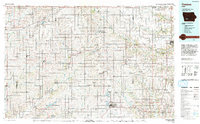
 1993 Guthrie Center1993 Print · USGSWestern Iowa in the early 1990s showcases a network of river-valley towns and essential rail corridors. Researchers can trace local landmarks like Violet Hill Cem and the Chicago and North Western RR through Coon Rapids and Panora.
 - 1993 Map of Creston
 1993 Creston1993 Print · USGSSouthwestern Iowa in the early nineties shows a landscape of established farm towns and modern water reservoirs. Genealogists and local historians can trace the streets of Creston and Winterset, or find rural landmarks like Graceland Cem and Arbor Hill.
End of results
Showing maps 1-2 of 2
Top cities near Earlham
- Waukee historical maps
- Adel historical maps
- Winterset historical maps
- Dallas Center historical maps
- Stuart historical maps
- Van Meter historical maps
See more
Frequently asked questions
- What are the different types of historical maps available for Earlham?
- What is the oldest map of Earlham?
- Where can I purchase historical maps of Earlham for my home or office?
- Where can I download high-res historical maps of Earlham?
- Are there historical topographic maps available for Earlham?
- Is there historical aerial imagery available for Earlham?
- Where are historical maps of Earlham sourced from?