1970s Maps of Sutherland, Iowa
Explore 2 historic maps of Sutherland from the 1970s. These maps offer a rare glimpse into what life looked like during the 1970s — showing old roads, neighborhoods, homes, and landmarks that have changed or disappeared over time.
Whether you're researching your family's past, planning a metal detecting trip, or studying how Sutherland's landscape evolved across the 1970s, these high-resolution maps are a powerful tool for exploring the history of this region.
- Focus on a specific era: All maps on this page are from the 1970s, giving you a focused view of this time period.
- See what’s changed: Compare century-old streets, trails, and buildings to today's modern landscape using overlays and satellite layers.
- Research with precision: Use these maps for genealogy, historical research, land use analysis, or educational projects.
- View, download, or print: Maps are fully viewable online in high resolution, and can be downloaded or printed for your own records.
Start exploring Sutherland's history through authentic maps from the 1970s. This is your window into the past.
Sutherland, IA maps
(2)- 1971 Map of Sutherland West, 1973 Print
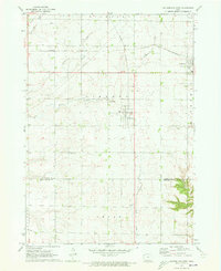 1971 Sutherland West1973 Print · USGSNorthwestern Iowa farm country is captured here in the early seventies, centered on the rail communities of Sutherland and Calumet. Genealogists and local researchers can trace family lands near Liberty Cem or locate old industrial sites like the local Gravel Pits.
 - 1971 Map of Sutherland East, 1973 Print
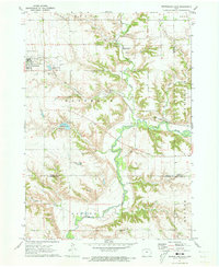 1971 Sutherland East1973 Print · USGSSutherland and the Little Sioux River valley are captured here in the early 1970s, showing a landscape defined by prairie agriculture and river bluffs. Researchers can locate Waterman Cem, the Chicago and North Western line, and Indian Village State Park.
End of results
Showing maps 1-2 of 2
Top cities near Sutherland
- Cherokee historical maps
- Hartley historical maps
- Sanborn historical maps
- Paullina historical maps
- Primghar historical maps
- Everly historical maps
See more
Frequently asked questions
- What are the different types of historical maps available for Sutherland?
- What is the oldest map of Sutherland?
- Where can I purchase historical maps of Sutherland for my home or office?
- Where can I download high-res historical maps of Sutherland?
- Are there historical topographic maps available for Sutherland?
- Is there historical aerial imagery available for Sutherland?
- Where are historical maps of Sutherland sourced from?