1980s Maps of Coin, Iowa
Explore 2 historic maps of Coin from the 1980s. These maps offer a rare glimpse into what life looked like during the 1980s — showing old roads, neighborhoods, homes, and landmarks that have changed or disappeared over time.
Whether you're researching your family's past, planning a metal detecting trip, or studying how Coin's landscape evolved across the 1980s, these high-resolution maps are a powerful tool for exploring the history of this region.
- Focus on a specific era: All maps on this page are from the 1980s, giving you a focused view of this time period.
- See what’s changed: Compare century-old streets, trails, and buildings to today's modern landscape using overlays and satellite layers.
- Research with precision: Use these maps for genealogy, historical research, land use analysis, or educational projects.
- View, download, or print: Maps are fully viewable online in high resolution, and can be downloaded or printed for your own records.
Start exploring Coin's history through authentic maps from the 1980s. This is your window into the past.
Coin, IA maps
(2)- 1981 Map of Coin
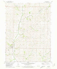 1981 Coin1981 Print · USGSSouthwestern Iowa's agricultural heartland is documented here in the early eighties, centered on the rail-linked community of Coin. Genealogists and researchers can trace local roots through Elmwood Cem, Yorktown, and the Old Railroad Grade.
 - 1985 Map of Nebraska City
 1985 Nebraska City1985 Print · USGSThe Missouri River borderlands of Nebraska, Iowa, and Missouri come into focus in the mid-1980s, showcasing a landscape of river navigation and rail-fed agriculture. Researchers can trace the heritage of Nebraska City, follow the Burlington Northern tracks, or explore river landmarks like Jones Point and McKissick Island.
End of results
Showing maps 1-2 of 2
Top cities near Coin
- Clarinda historical maps
- Shenandoah historical maps
- Tarkio historical maps
- Essex historical maps
- Burlington Junction historical maps
- Clearmont historical maps
See more
Frequently asked questions
- What are the different types of historical maps available for Coin?
- What is the oldest map of Coin?
- Where can I purchase historical maps of Coin for my home or office?
- Where can I download high-res historical maps of Coin?
- Are there historical topographic maps available for Coin?
- Is there historical aerial imagery available for Coin?
- Where are historical maps of Coin sourced from?