1970s Maps of Nevada, Iowa
Explore 3 historic maps of Nevada from the 1970s. These maps offer a rare glimpse into what life looked like during the 1970s — showing old roads, neighborhoods, homes, and landmarks that have changed or disappeared over time.
Whether you're researching your family's past, planning a metal detecting trip, or studying how Nevada's landscape evolved across the 1970s, these high-resolution maps are a powerful tool for exploring the history of this region.
- Focus on a specific era: All maps on this page are from the 1970s, giving you a focused view of this time period.
- See what’s changed: Compare century-old streets, trails, and buildings to today's modern landscape using overlays and satellite layers.
- Research with precision: Use these maps for genealogy, historical research, land use analysis, or educational projects.
- View, download, or print: Maps are fully viewable online in high resolution, and can be downloaded or printed for your own records.
Start exploring Nevada's history through authentic maps from the 1970s. This is your window into the past.
Nevada, IA maps
(3)- 1975 Map of Nevada, 1978 Print
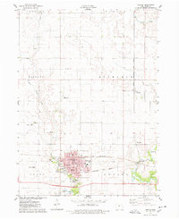 1975 Nevada1978 Print · USGSStory County's landscape in the mid-seventies shows a bustling rail-and-river hub at the height of its mid-century growth. Researchers can trace the civic footprint of Nevada through the Courthouse and Oak Park Academy or locate local landmarks like Knoll Cem and the Paul Landing Strip.
 - 1975 Map of Ames East, 1978 Print
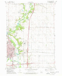 1975 Ames East1978 Print · USGSAmes was expanding along the Skunk River in the mid-1970s, as agricultural research and transit networks shaped the local landscape. Researchers can locate the National Animal Disease Laboratory, the Born Cem, and the tracks of the Chicago and North Western railroad.2 unique versions available
 - 1975 Map of Maxwell, 1978 Print
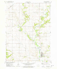 1975 Maxwell1978 Print · USGSThis mid-1970s survey of southeastern Story County captures the agricultural heartland as the local rail and road networks matured. Genealogists and local historians can trace family roots through sites like Iowa Center, Center Grove Cem, and the historic street grid of Maxwell.
End of results
Showing maps 1-3 of 3
Top cities near Nevada
- Ankeny historical maps
- Ames historical maps
- Polk City historical maps
- Huxley historical maps
- Story City historical maps
- Slater historical maps
See more
Frequently asked questions
- What are the different types of historical maps available for Nevada?
- What is the oldest map of Nevada?
- Where can I purchase historical maps of Nevada for my home or office?
- Where can I download high-res historical maps of Nevada?
- Are there historical topographic maps available for Nevada?
- Is there historical aerial imagery available for Nevada?
- Where are historical maps of Nevada sourced from?