1940s Maps of Walnut Township, Kansas
Explore 2 historic maps of Walnut Township from the 1940s. These maps offer a rare glimpse into what life looked like during the 1940s — showing old roads, neighborhoods, homes, and landmarks that have changed or disappeared over time.
Whether you're researching your family's past, planning a metal detecting trip, or studying how Walnut Township's landscape evolved across the 1940s, these high-resolution maps are a powerful tool for exploring the history of this region.
- Focus on a specific era: All maps on this page are from the 1940s, giving you a focused view of this time period.
- See what’s changed: Compare century-old streets, trails, and buildings to today's modern landscape using overlays and satellite layers.
- Research with precision: Use these maps for genealogy, historical research, land use analysis, or educational projects.
- View, download, or print: Maps are fully viewable online in high resolution, and can be downloaded or printed for your own records.
Start exploring Walnut Township's history through authentic maps from the 1940s. This is your window into the past.
Walnut Township, KS maps
(2)- 1948 Map of Oak Mills, 1954 Print
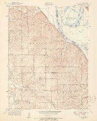 1948 Oak Mills1954 Print · USGSNortheastern Kansas in the late 1940s is captured here, showing the river bluffs and rail lines between Atchison and Leavenworth. Researchers can trace rural life through landmarks like Oak Mills, Lowemont, and numerous country schools such as Rock School and Wyman Sch.2 unique versions available
 - 1948 Map of Leavenworth, 1957 Print
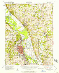 1948 Leavenworth1957 Print · USGSThe Missouri River corridor near Leavenworth and Weston was a vital hub of military and civic institutions in the late 1940s. Genealogists and historians can trace family roots at the Society of Sons of Death Cemetery or locate old schoolhouses like Coffin School and Hund School.4 unique versions available
End of results
Showing maps 1-2 of 2
Top cities near Walnut Township
- Saint Joseph historical maps
- Leavenworth historical maps
- Lansing historical maps
- Atchison historical maps
- Kickapoo historical maps
- Shannon historical maps
See more
Top neighborhoods of Walnut Township
- Dalbey historical maps
- Oak Mills historical maps
- Port Williams historical maps
- Saint Pats historical maps
Frequently asked questions
- What are the different types of historical maps available for Walnut Township?
- What is the oldest map of Walnut Township?
- Where can I purchase historical maps of Walnut Township for my home or office?
- Where can I download high-res historical maps of Walnut Township?
- Are there historical topographic maps available for Walnut Township?
- Is there historical aerial imagery available for Walnut Township?
- Where are historical maps of Walnut Township sourced from?