1970s Maps of Anthony, Kansas
Explore 3 historic maps of Anthony from the 1970s. These maps offer a rare glimpse into what life looked like during the 1970s — showing old roads, neighborhoods, homes, and landmarks that have changed or disappeared over time.
Whether you're researching your family's past, planning a metal detecting trip, or studying how Anthony's landscape evolved across the 1970s, these high-resolution maps are a powerful tool for exploring the history of this region.
- Focus on a specific era: All maps on this page are from the 1970s, giving you a focused view of this time period.
- See what’s changed: Compare century-old streets, trails, and buildings to today's modern landscape using overlays and satellite layers.
- Research with precision: Use these maps for genealogy, historical research, land use analysis, or educational projects.
- View, download, or print: Maps are fully viewable online in high resolution, and can be downloaded or printed for your own records.
Start exploring Anthony's history through authentic maps from the 1970s. This is your window into the past.
Anthony, KS maps
(3)- 1971 Map of Bluff City NW, 1973 Print
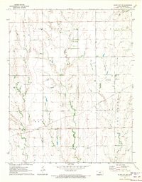 1971 Bluff City NW1973 Print · USGSHarper County's rural landscape is captured here in the early seventies, where the energy industry and rail transport intersect. Trace the path of the Missouri Pacific or locate local landmarks like Pilot Knob and the Stohrville Oil Field.
 - 1972 Map of Anthony, 1975 Print
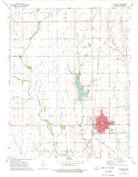 1972 Anthony1975 Print · USGSThe Harper County seat of Anthony is captured here during the early 1970s, showing a well-established plains community and its vital rail connections. Genealogists and researchers can locate Spring Grove Cemetery, trace the path of the Missouri Pacific railroad, or find the site of the old Drive-in Theater.2 unique versions available
 - 1972 Map of Spring, 1975 Print
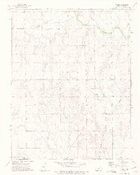 1972 Spring1975 Print · USGSIn the early seventies, the borderlands of Harper County were defined by rural rail lines and the straight path of the Old Indian Treaty Boundary. Researchers can trace the legacy of the Spring settlement and locate rural landmarks like Hopewell Ch and Burchfiel Ch.
End of results
Showing maps 1-3 of 3
Top cities near Anthony
- Harper historical maps
- Attica historical maps
- Manchester historical maps
- Bluff City historical maps
- Danville historical maps
- Waldron historical maps
See more
Frequently asked questions
- What are the different types of historical maps available for Anthony?
- What is the oldest map of Anthony?
- Where can I purchase historical maps of Anthony for my home or office?
- Where can I download high-res historical maps of Anthony?
- Are there historical topographic maps available for Anthony?
- Is there historical aerial imagery available for Anthony?
- Where are historical maps of Anthony sourced from?