1960s Maps of Holton, Kansas
Explore 3 historic maps of Holton from the 1960s. These maps offer a rare glimpse into what life looked like during the 1960s — showing old roads, neighborhoods, homes, and landmarks that have changed or disappeared over time.
Whether you're researching your family's past, planning a metal detecting trip, or studying how Holton's landscape evolved across the 1960s, these high-resolution maps are a powerful tool for exploring the history of this region.
- Focus on a specific era: All maps on this page are from the 1960s, giving you a focused view of this time period.
- See what’s changed: Compare century-old streets, trails, and buildings to today's modern landscape using overlays and satellite layers.
- Research with precision: Use these maps for genealogy, historical research, land use analysis, or educational projects.
- View, download, or print: Maps are fully viewable online in high resolution, and can be downloaded or printed for your own records.
Start exploring Holton's history through authentic maps from the 1960s. This is your window into the past.
Holton, KS maps
(3)- 1960 Map of Kansas City
 1960 Kansas City1960 Print · USGSMid-century Kansas and Missouri meet at the river forks, showing a sprawling rail-and-river economy during the 1950s growth era. Genealogists and researchers can trace tribal lands like the Kickapoo Indian Reservation or follow the early interstate corridors through Saint Joseph and Independence.3 unique versions available
 - 1960 Map of Holton, 1961 Print
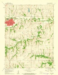 1960 Holton1961 Print · USGSJackson County at the start of the sixties reveals a landscape of established townships and significant historical borders. Genealogists and historians can trace family-named sites and public markers such as Brick Cem, the Potawatomi Indian Res Boundary, and the Grange Hall.3 unique versions available
 - 1960 Map of Soldier Creek NE, 1962 Print
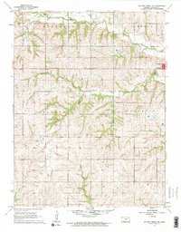 1960 Soldier Creek NE1962 Print · USGSJackson County agricultural life is captured here in the early sixties, centered on the western outskirts of Holton. Genealogists and historians can locate the Old Potawatomi Indian Reservation Boundary and rural sites like Catholic Cemetery or Banner School.
End of results
Showing maps 1-3 of 3
Top cities near Holton
- Horton historical maps
- Hoyt historical maps
- Mayetta historical maps
- Wetmore historical maps
- Denison historical maps
- Whiting historical maps
See more
Frequently asked questions
- What are the different types of historical maps available for Holton?
- What is the oldest map of Holton?
- Where can I purchase historical maps of Holton for my home or office?
- Where can I download high-res historical maps of Holton?
- Are there historical topographic maps available for Holton?
- Is there historical aerial imagery available for Holton?
- Where are historical maps of Holton sourced from?