1960s Maps of Lakin, Kansas
Explore 2 historic maps of Lakin from the 1960s. These maps offer a rare glimpse into what life looked like during the 1960s — showing old roads, neighborhoods, homes, and landmarks that have changed or disappeared over time.
Whether you're researching your family's past, planning a metal detecting trip, or studying how Lakin's landscape evolved across the 1960s, these high-resolution maps are a powerful tool for exploring the history of this region.
- Focus on a specific era: All maps on this page are from the 1960s, giving you a focused view of this time period.
- See what’s changed: Compare century-old streets, trails, and buildings to today's modern landscape using overlays and satellite layers.
- Research with precision: Use these maps for genealogy, historical research, land use analysis, or educational projects.
- View, download, or print: Maps are fully viewable online in high resolution, and can be downloaded or printed for your own records.
Start exploring Lakin's history through authentic maps from the 1960s. This is your window into the past.
Lakin, KS maps
(2)- 1960 Map of Deerfield, 1961 Print
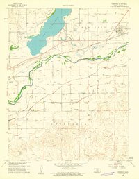 1960 Deerfield1961 Print · USGSDeerfield and the Arkansas River valley are shown in the early 1960s during a period of significant irrigation and energy development. Genealogists and historians can trace the complex network of the Amazon Canal and Southside Ditch alongside the Lakin Cem and Pioneer Community Hall.2 unique versions available
 - 1966 Map of Lakin, 1967 Print
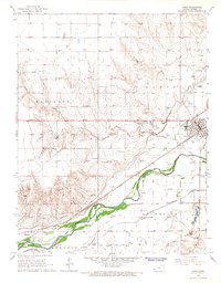 1966 Lakin1967 Print · USGSKearny County agriculture and industry meet along the Arkansas River in the mid-1960s. Genealogists and historians can trace the irrigation network of the Amazon Ditch and locate the Hartland Cem near the Hartland settlement.2 unique versions available
End of results
Showing maps 1-2 of 2
Top cities near Lakin
Frequently asked questions
- What are the different types of historical maps available for Lakin?
- What is the oldest map of Lakin?
- Where can I purchase historical maps of Lakin for my home or office?
- Where can I download high-res historical maps of Lakin?
- Are there historical topographic maps available for Lakin?
- Is there historical aerial imagery available for Lakin?
- Where are historical maps of Lakin sourced from?