1900s (20th Century) Maps of Johnson City, Kansas
Explore 9 historic maps of Johnson City from the 1900s (20th Century). These maps offer a rare glimpse into what life looked like during the 1900s — showing old roads, neighborhoods, homes, and landmarks that have changed or disappeared over time.
Whether you're researching your family's past, planning a metal detecting trip, or studying how Johnson City's landscape evolved across the 1900s, these high-resolution maps are a powerful tool for exploring the history of this region.
- Focus on a specific era: All maps on this page are from the 1900s, giving you a focused view of this time period.
- See what’s changed: Compare century-old streets, trails, and buildings to today's modern landscape using overlays and satellite layers.
- Research with precision: Use these maps for genealogy, historical research, land use analysis, or educational projects.
- View, download, or print: Maps are fully viewable online in high resolution, and can be downloaded or printed for your own records.
Start exploring Johnson City's history through authentic maps from the 1900s. This is your window into the past.
Johnson City, KS maps
(9)- 1900 Map of Syracuse
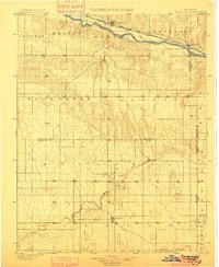 1900 Syracuse1900 Print · USGSWestern Kansas at the turn of the century shows a frontier landscape shaped by the Arkansas River and the arriving railroad. Genealogists and researchers can locate early settlements like Hatton, Edwin, and Gognac along with the path of the Atchison Topeka and Santa Fe.5 unique versions available
 - 1920 Map of Syracuse
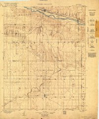 1920 Syracuse1920 Print · USGSWestern Kansas at the close of the frontier era centers on the vital Arkansas River valley and the reach of the railroad. Genealogists and local historians can trace early prairie settlements like Gognac, Hatton, and Kendall along the Atchison Topeka and Santa Fe line.
 - 1955 Map of Dodge City, 1968 Print
 1955 Dodge City1968 Print · USGSSouthwest Kansas in the mid-fifties reveals an expansive landscape of cattle towns, early gas fields, and prairie outposts. Researchers can trace rural school districts like Moundview and Good Luck or locate the Kansas State Game Farm near Lakin.3 unique versions available
 - 1958 Map of Dodge City
 1958 Dodge City1958 Print · USGSSouthwest Kansas in the late fifties shows a landscape of river-valley agriculture and burgeoning energy infrastructure. Genealogists can trace rural life through numerous landmarks like Fairview Cemetery, the Goodwell School, and Concord Church.
 - 1959 Map of Dodge City
 1959 Dodge City1959 Print · USGSSouthwest Kansas in the mid-fifties is captured at its agricultural height, centered on the vital rail and river hubs of Dodge City and Garden City. Genealogists and local historians can trace rural school districts like Shockey School and Hickok School or locate the Fairview Cemetery.
 - 1959 Map of Big Bow SW, 1960 Print
 1959 Big Bow SW1960 Print · USGSStanton County at the end of the fifties reveals a landscape defined by natural drainage and energy extraction. Researchers can trace the path of Sandy Arroyo Creek or locate the numerous Gas Wells and the Atchison Topeka and Santa Fe rail line.3 unique versions available
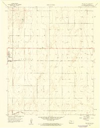
 - 1973 Map of Johnson West, 1975 Print
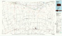
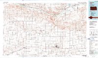
 1973 Johnson West1975 Print · USGSStanton County at the dawn of the 1970s reveals a landscape defined by industrial agriculture and rail. Genealogists and historians can trace the outskirts of Johnson City and locate landmarks like the County Cemetery and Baughman.
 - 1985 Map of Ulysses
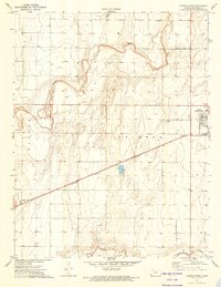
 1985 Ulysses1985 Print · USGSSouthwestern Kansas in the mid-1980s reveals a landscape shaped by massive gas fields and the life-giving waters of the Arkansas River. Genealogists and researchers can trace the rail towns of the Atchison Topeka and Santa Fe, locate the Syracuse Cem, or explore the rural routes of Sullivans Track and Columbian Track.
 - 1987 Map of Ulysses, 1988 Print
 1987 Ulysses1988 Print · USGSWestern Kansas at the end of the Cold War was a landscape defined by natural gas production and rail-fed agriculture. Trace the energy and transport networks connecting Ulysses, Big Bow, and the Arkansas River corridor along the Atchison Topeka and Santa Fe railroad.
End of results
Showing maps 1-9 of 9
Top cities near Johnson City
Top neighborhoods of Johnson City
Frequently asked questions
- What are the different types of historical maps available for Johnson City?
- What is the oldest map of Johnson City?
- Where can I purchase historical maps of Johnson City for my home or office?
- Where can I download high-res historical maps of Johnson City?
- Are there historical topographic maps available for Johnson City?
- Is there historical aerial imagery available for Johnson City?
- Where are historical maps of Johnson City sourced from?