1900s (20th Century) Maps of Hegira, Kentucky
Explore 8 historic maps of Hegira from the 1900s (20th Century). These maps offer a rare glimpse into what life looked like during the 1900s — showing old roads, neighborhoods, homes, and landmarks that have changed or disappeared over time.
Whether you're researching your family's past, planning a metal detecting trip, or studying how Hegira's landscape evolved across the 1900s, these high-resolution maps are a powerful tool for exploring the history of this region.
- Focus on a specific era: All maps on this page are from the 1900s, giving you a focused view of this time period.
- See what’s changed: Compare century-old streets, trails, and buildings to today's modern landscape using overlays and satellite layers.
- Research with precision: Use these maps for genealogy, historical research, land use analysis, or educational projects.
- View, download, or print: Maps are fully viewable online in high resolution, and can be downloaded or printed for your own records.
Start exploring Hegira's history through authentic maps from the 1900s. This is your window into the past.
Hegira, KY maps
(8)- 1924 Map of Lillydale
 1924 Lillydale1924 Print · USGSThe Tennessee-Kentucky borderlands in the early twenties were defined by tight river bends and isolated ridge-top schools. Genealogists can trace the rural life of Lillydale through landmarks like Thompsons Store, Willow Grove, and the uniquely named Hongkong School.
 - 1926 Map of Lillydale, 1964 Print
 1926 Lillydale1964 Print · USGSThe Cumberland and Obey Rivers wind through this border region in the mid-twenties, documenting life before the damming of the river valleys. Genealogists can trace family footprints at Lillydale, Carys Ferry, and numerous rural schoolhouses like Greenbrier School.
 - 1929 Map of Lillydale
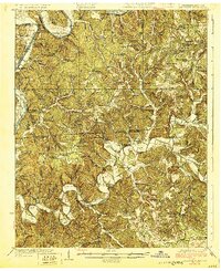 1929 Lillydale1929 Print · USGSThe Tennessee and Kentucky borderlands are captured here in the 1920s, showing a river-linked landscape of bottomland farms and ridge-top communities. Genealogists can trace family roots through numerous schools and churches like Bearwallow School, Lillydale, and History Grove Church.3 unique versions available
 - 1954 Map of Frogue, 1955 Print
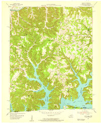 1954 Frogue1955 Print · USGSCumberland County and the Tennessee borderlands are shown here in the mid-fifties, just as the rising waters of Dale Hollow Reservoir reshaped the valley. Researchers can locate vanished landmarks like Neeleys Fy on the river and rural centers like Spears Chapel and Hegira.2 unique versions available
 - 1956 Map of Corbin, 1966 Print
 1956 Corbin1966 Print · USGSThe Kentucky and Tennessee borderlands are captured here in the mid-fifties, showing the region's shift toward modern interstate travel and reservoir development. Genealogists and historians can trace old community lines near Albany and Monticello or locate early rail junctions along the Southern and Tennessee Central lines.3 unique versions available
 - 1958 Map of Corbin
 1958 Corbin1958 Print · USGSThe Upper Cumberland borderlands appear in the late 1950s as massive reservoirs and early atomic-era growth reshape the region. Trace family roots and vanished landmarks near Lake Cumberland, Oak Ridge, and the Cumberland National Forest.
 - 1978 Map of Frogue, 1979 Print
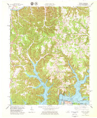 1978 Frogue1979 Print · USGSCumberland and Clinton Counties appear here in the late seventies as the terrain transitions from the Cumberland River to the inlets of Dale Hollow Lake. Researchers can trace rural landmarks from Sexton Park Ch to the many Oil Wells marking the local hillsides.2 unique versions available
 - 1985 Map of Tompkinsville, 1986 Print
 1985 Tompkinsville1986 Print · USGSThe Kentucky-Tennessee borderlands come into focus in the mid-1980s, showcasing a landscape of river-fed valleys and rural crossroads. Genealogists and local historians can trace family locations from Glasgow and Edmonton to the distinctively named Eighty Eight, Bugtussle, and Akersville.2 unique versions available
End of results
Showing maps 1-8 of 8
Top cities near Hegira
Frequently asked questions
- What are the different types of historical maps available for Hegira?
- What is the oldest map of Hegira?
- Where can I purchase historical maps of Hegira for my home or office?
- Where can I download high-res historical maps of Hegira?
- Are there historical topographic maps available for Hegira?
- Is there historical aerial imagery available for Hegira?
- Where are historical maps of Hegira sourced from?