1900s (20th Century) Maps of Clarkson, Kentucky
Explore 15 historic maps of Clarkson from the 1900s (20th Century). These maps offer a rare glimpse into what life looked like during the 1900s — showing old roads, neighborhoods, homes, and landmarks that have changed or disappeared over time.
Whether you're researching your family's past, planning a metal detecting trip, or studying how Clarkson's landscape evolved across the 1900s, these high-resolution maps are a powerful tool for exploring the history of this region.
- Focus on a specific era: All maps on this page are from the 1900s, giving you a focused view of this time period.
- See what’s changed: Compare century-old streets, trails, and buildings to today's modern landscape using overlays and satellite layers.
- Research with precision: Use these maps for genealogy, historical research, land use analysis, or educational projects.
- View, download, or print: Maps are fully viewable online in high resolution, and can be downloaded or printed for your own records.
Start exploring Clarkson's history through authentic maps from the 1900s. This is your window into the past.
Clarkson, KY maps
(15)- 1925 Map of Cub Run
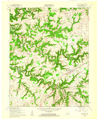
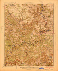 1925 Cub Run1925 Print · USGSCentral Kentucky's rural landscape is captured here in the mid-1920s, dominated by the intricate loops of the Nolin River. Genealogists and historians can locate numerous family-named landmarks like Dickeys Mills, Sanders Store, and Hester School.3 unique versions available
 - 1932 Map of Big Clifty
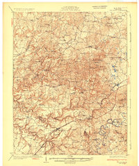 1932 Big Clifty1932 Print · USGSGrayson and Hardin Counties are captured here between the World Wars, showing a rural landscape defined by the Illinois Central Railroad and the Dixie Highway. Genealogists and historians can locate dozens of small community centers like Big Clifty, White Mills, and the Asphalt Mine.5 unique versions available
 - 1949 Map of Big Clifty, 1952 Print
 1949 Big Clifty1952 Print · USGSMid-century Grayson County comes to life in this detailed survey of the central Kentucky uplands during the postwar years. Local historians can trace the Illinois Central line through Big Clifty or locate ancestral sites like Smith Chapel and the Ford Sch.
 - 1949 Map of Big Clifty, 1959 Print
 1949 Big Clifty1959 Print · USGSThe rural communities of Grayson and Hardin counties are captured in the late 1940s, a time when small schoolhouses and country churches still anchored local life. Researchers can trace family roots at St Elizabeth Cem or locate long-standing landmarks like Pierce Mill and the Needham Chapel Ch along the Rough River.
 - 1954 Map of Evansville
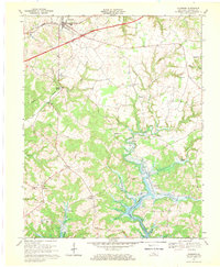
 1954 Evansville1954 Print · USGSThe Ohio River borderlands between Indiana and Kentucky appear here during a period of robust industrial and military growth. Genealogists and researchers can trace the rail corridors of the Illinois Central and find landmarks like US Lock and Dam No 48 or Camp Breckinridge.
 - 1954 Map of Clarkson, 1955 Print
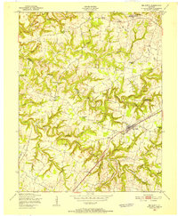
 1954 Clarkson1955 Print · USGSGrayson County's hilly heartland in the early fifties shows a landscape of small crossroads and parochial centers. Trace family sites and former schools like St Anthony Sch, the Illinois Central line, and communities from Peonia to Grayson Springs.
 - 1957 Map of Evansville, 1969 Print
 1957 Evansville1969 Print · USGSIndiana and Kentucky meet along the Ohio River in this mid-century survey of a vital industrial and transport corridor. Genealogists and historians can trace the development of river towns like Owensboro and Newburgh or locate old rail lines like the Southern Ry.3 unique versions available
 - 1960 Map of Big Clifty, 1961 Print
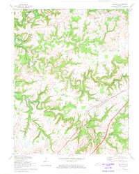
 1960 Big Clifty1961 Print · USGSGrayson and Hardin counties are shown in the early sixties as the railroad and river define the local pace of life. Researchers can trace family sites like St Pauls Ch, the Johnson School, and small rail stops from Big Clifty to West Clifty.
 - 1961 Map of Evansville
 1961 Evansville1961 Print · USGSThe Ohio River valley and its surrounding coalfields are captured here during the late fifties and early sixties. Trace the industrial rail networks of the Illinois Central RR and explore regional landmarks like Mammoth Cave National Park and Angel Mounds State Memorial.2 unique versions available
 - 1967 Map of Clarkson, 1969 Print
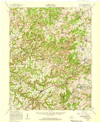
 1967 Clarkson1969 Print · USGSGrayson County's landscape is caught between its rail-era roots and modern highway expansion during the late sixties. Genealogists and local historians can trace family locations near Grayson Springs, Peonia, and St Augustines Ch or explore the newly flooded banks of the Nolin Reservoir.
 - 1972 Map of Big Clifty, 1973 Print
 1972 Big Clifty1973 Print · USGSGrayson County in the early 1970s shows a landscape of winding river valleys and rural crossroads. Genealogists can trace family names through St Paul's Cemetery and locate former educational sites like Goodman School and Western Consolidated School.
 - 1981 Map of Beaver Dam, 1984 Print
 1981 Beaver Dam1984 Print · USGSThe Western Kentucky coal and river country comes into focus in the early 1980s as industry and recreation reshape the land. Researchers can trace family roots and old routes through Morgantown, Beaver Dam, and the early footprints of Mammoth Cave National Park.
 - 1986 Map of Tell City
 1986 Tell City1986 Print · USGSThe Ohio River valley and the Kentucky interior come alive in this mid-eighties record of industry and recreation. Genealogists and historians can trace small rural settlements like Victoria Crossroads, local landmarks such as St Rose, and the extensive shoreline of Rough River Lake.
 - 1991 Map of Tell City
 1991 Tell City1991 Print · USGSThe Ohio River valley at the start of the nineties reveals a landscape of riverfront industry and sprawling conservation lands. Genealogists can locate family landmarks like Wesley Chapel and rural communities such as Reynolds Station and Maceo.
 - 1991 Map of Big Clifty, 1992 Print
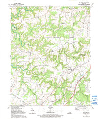 1991 Big Clifty1992 Print · USGSGrayson and Hardin counties are captured here in the early nineties, showing the ridge-and-hollow farming landscape of central Kentucky. Researchers can trace family sites at Cedar Hill Cem or locate former hubs like Saint Paul and the Goodman Sch.
End of results
Showing maps 1-15 of 15
Top cities near Clarkson
Frequently asked questions
- What are the different types of historical maps available for Clarkson?
- What is the oldest map of Clarkson?
- Where can I purchase historical maps of Clarkson for my home or office?
- Where can I download high-res historical maps of Clarkson?
- Are there historical topographic maps available for Clarkson?
- Is there historical aerial imagery available for Clarkson?
- Where are historical maps of Clarkson sourced from?