1960s Maps of Leitchfield, Kentucky
Explore 4 historic maps of Leitchfield from the 1960s. These maps offer a rare glimpse into what life looked like during the 1960s — showing old roads, neighborhoods, homes, and landmarks that have changed or disappeared over time.
Whether you're researching your family's past, planning a metal detecting trip, or studying how Leitchfield's landscape evolved across the 1960s, these high-resolution maps are a powerful tool for exploring the history of this region.
- Focus on a specific era: All maps on this page are from the 1960s, giving you a focused view of this time period.
- See what’s changed: Compare century-old streets, trails, and buildings to today's modern landscape using overlays and satellite layers.
- Research with precision: Use these maps for genealogy, historical research, land use analysis, or educational projects.
- View, download, or print: Maps are fully viewable online in high resolution, and can be downloaded or printed for your own records.
Start exploring Leitchfield's history through authentic maps from the 1960s. This is your window into the past.
Leitchfield, KY maps
(4)- 1961 Map of Evansville
 1961 Evansville1961 Print · USGSThe Ohio River valley and its surrounding coalfields are captured here during the late fifties and early sixties. Trace the industrial rail networks of the Illinois Central RR and explore regional landmarks like Mammoth Cave National Park and Angel Mounds State Memorial.2 unique versions available
 - 1963 Map of Madrid, 1976 Print
 1963 Madrid1976 Print · USGSGrayson and Breckinridge Counties are captured here in the early sixties as the reservoir waters of Rough River Lake reshaped the valley. Trace local roots at sites like Antioch Ch, Mullins Cem, and the old Conklin Sch.2 unique versions available
 - 1967 Map of Leitchfield, 1968 Print
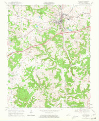 1967 Leitchfield1968 Print · USGSGrayson County's landscape undergoes a transformation in the late sixties as modern highways reach the outskirts of Leitchfield. Genealogists can trace family names at Kefauver Cem and William Cem, or locate rural landmarks like Black Rock and Liberty Ch.2 unique versions available
 - 1967 Map of Clarkson, 1969 Print
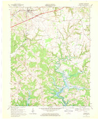 1967 Clarkson1969 Print · USGSGrayson County's landscape is caught between its rail-era roots and modern highway expansion during the late sixties. Genealogists and local historians can trace family locations near Grayson Springs, Peonia, and St Augustines Ch or explore the newly flooded banks of the Nolin Reservoir.
End of results
Showing maps 1-4 of 4
Top cities near Leitchfield
Frequently asked questions
- What are the different types of historical maps available for Leitchfield?
- What is the oldest map of Leitchfield?
- Where can I purchase historical maps of Leitchfield for my home or office?
- Where can I download high-res historical maps of Leitchfield?
- Are there historical topographic maps available for Leitchfield?
- Is there historical aerial imagery available for Leitchfield?
- Where are historical maps of Leitchfield sourced from?