1910s Maps of Clovertown, Kentucky
Explore 2 historic maps of Clovertown from the 1910s. These maps offer a rare glimpse into what life looked like during the 1910s — showing old roads, neighborhoods, homes, and landmarks that have changed or disappeared over time.
Whether you're researching your family's past, planning a metal detecting trip, or studying how Clovertown's landscape evolved across the 1910s, these high-resolution maps are a powerful tool for exploring the history of this region.
- Focus on a specific era: All maps on this page are from the 1910s, giving you a focused view of this time period.
- See what’s changed: Compare century-old streets, trails, and buildings to today's modern landscape using overlays and satellite layers.
- Research with precision: Use these maps for genealogy, historical research, land use analysis, or educational projects.
- View, download, or print: Maps are fully viewable online in high resolution, and can be downloaded or printed for your own records.
Start exploring Clovertown's history through authentic maps from the 1910s. This is your window into the past.
Clovertown, KY maps
(2)- 1916 Map of Harlan
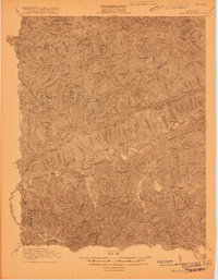 1916 Harlan1916 Print · USGSHarlan and the Cumberland River valley are captured here in the years before the coal boom fully reshaped the landscape. Researchers can trace early settlements like White Star and Black Joe, find the Pine Branch School, and locate mountain inclines.
 - 1919 Map of Harlan
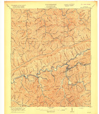 1919 Harlan1919 Print · USGSHarlan County's coal country is captured here during the expansion of the rail-and-river economy. Genealogists and historians can trace the foundations of mountain communities along the Cumberland River, locating early sites like Wallins Creek, Kentenia, and the Wood Sta Blackjoe PO.4 unique versions available
End of results
Showing maps 1-2 of 2
Top cities near Clovertown
- Harlan historical maps
- Jonesville historical maps
- Evarts historical maps
- Rose Hill historical maps
- Loyall historical maps
- Ewing historical maps
See more
Frequently asked questions
- What are the different types of historical maps available for Clovertown?
- What is the oldest map of Clovertown?
- Where can I purchase historical maps of Clovertown for my home or office?
- Where can I download high-res historical maps of Clovertown?
- Are there historical topographic maps available for Clovertown?
- Is there historical aerial imagery available for Clovertown?
- Where are historical maps of Clovertown sourced from?