1930s Maps of Martins Fork, Kentucky
Explore 2 historic maps of Martins Fork from the 1930s. These maps offer a rare glimpse into what life looked like during the 1930s — showing old roads, neighborhoods, homes, and landmarks that have changed or disappeared over time.
Whether you're researching your family's past, planning a metal detecting trip, or studying how Martins Fork's landscape evolved across the 1930s, these high-resolution maps are a powerful tool for exploring the history of this region.
- Focus on a specific era: All maps on this page are from the 1930s, giving you a focused view of this time period.
- See what’s changed: Compare century-old streets, trails, and buildings to today's modern landscape using overlays and satellite layers.
- Research with precision: Use these maps for genealogy, historical research, land use analysis, or educational projects.
- View, download, or print: Maps are fully viewable online in high resolution, and can be downloaded or printed for your own records.
Start exploring Martins Fork's history through authentic maps from the 1930s. This is your window into the past.
Martins Fork, KY maps
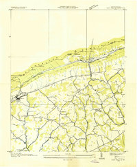
(2)- 1932 Map of Hagan
 1932 Hagan1932 Print · USGSThe rugged borderlands of Kentucky and Virginia come to life in this early 1930s survey of the high gaps and hollows. Researchers can locate remote mountain landmarks like Hensley Sch, Feepee Store, and the scattered cabins at Alva.3 unique versions available
 - 1935 Map of Rose Hill
 1935 Rose Hill1935 Print · USGSLee County in the mid-1930s shows a landscape of deep-rooted settlements and early Depression-era federal projects. Researchers can trace the Old Wilderness Trail, locate the CCC Camp TVA No 5, and find family landmarks like Grabeels Mill or the Engle Cem.
End of results
Showing maps 1-2 of 2
Top cities near Martins Fork
- Tazewell historical maps
- Harlan historical maps
- Sneedville historical maps
- Jonesville historical maps
- Evarts historical maps
- Rose Hill historical maps
See more
Frequently asked questions
- What are the different types of historical maps available for Martins Fork?
- What is the oldest map of Martins Fork?
- Where can I purchase historical maps of Martins Fork for my home or office?
- Where can I download high-res historical maps of Martins Fork?
- Are there historical topographic maps available for Martins Fork?
- Is there historical aerial imagery available for Martins Fork?
- Where are historical maps of Martins Fork sourced from?