1900s (20th Century) Maps of Hyden, Kentucky
Explore 11 historic maps of Hyden from the 1900s (20th Century). These maps offer a rare glimpse into what life looked like during the 1900s — showing old roads, neighborhoods, homes, and landmarks that have changed or disappeared over time.
Whether you're researching your family's past, planning a metal detecting trip, or studying how Hyden's landscape evolved across the 1900s, these high-resolution maps are a powerful tool for exploring the history of this region.
- Focus on a specific era: All maps on this page are from the 1900s, giving you a focused view of this time period.
- See what’s changed: Compare century-old streets, trails, and buildings to today's modern landscape using overlays and satellite layers.
- Research with precision: Use these maps for genealogy, historical research, land use analysis, or educational projects.
- View, download, or print: Maps are fully viewable online in high resolution, and can be downloaded or printed for your own records.
Start exploring Hyden's history through authentic maps from the 1900s. This is your window into the past.
Hyden, KY maps
(11)- 1916 Map of Hyden
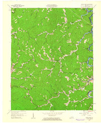
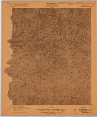 1916 Hyden1916 Print · USGSThe deep hollows of the Kentucky mountains are captured here during the First World War, just as small communities began to coalesce along the waterways. Genealogists can trace family footprints near Hoskinson, Chappell, and landmarks like Levi Lewis Creek.
 - 1919 Map of Hyden
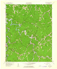
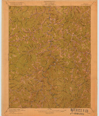 1919 Hyden1919 Print · USGSThe Middle Fork of the Kentucky River winds through Leslie County during the era of early mountain settlement. Genealogists and researchers can trace family landmarks along Hell for Certain Creek or locate old homesteads near Asher and Wooton.2 unique versions available
 - 1953 Map of Hyden West, 1954 Print
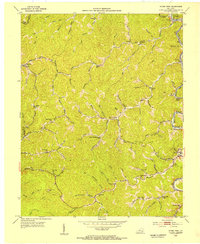 1953 Hyden West1954 Print · USGSCentral Leslie County comes into focus in the early fifties, documenting the remote mountain hollows and community hubs of the Kentucky hills. Genealogists can trace family names through landmarks like Thousandsticks, Hals Fork Sch, and the Brethren Ch.
 - 1954 Map of Hyden East, 1955 Print
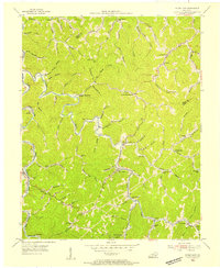 1954 Hyden East1955 Print · USGSLeslie County mountain communities are captured in the mid-1950s, showing the ridge-and-hollow life of the Kentucky Appalachians. Genealogists can trace family roots through numerous mountain schoolhouses like Avawam Sch and Flackey Sch or the riverside settlement at Wendover.
 - 1957 Map of Jenkins, 1974 Print
 1957 Jenkins1974 Print · USGSThe Cumberland Plateau in the mid-twentieth century reveals a complex landscape of winding river valleys and deep-seated industry. Genealogists and historians can trace the development of Hazard, Jenkins, and Pikeville alongside extensive Numerous Oil and Gas Fields and the routes of the Chesapeake & Ohio Railway.
 - 1960 Map of Jenkins
 1960 Jenkins1960 Print · USGSEastern Kentucky and the West Virginia borderlands are captured at a mid-century peak of the coal and rail era. Trace the industrial corridors of the Chesapeake and Ohio RR through mountain hubs like Hazard and Jenkins.
 - 1961 Map of Hyden West, 1962 Print
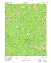
 1961 Hyden West1962 Print · USGSLeslie County during the early 1960s shows a landscape of deep hollows and river bends before modern highway expansion. You can trace family locations near Thousandsticks, find the local Drive-in Theater, or locate rural landmarks like Grace Chapel.2 unique versions available
 - 1961 Map of Hyden East, 1963 Print
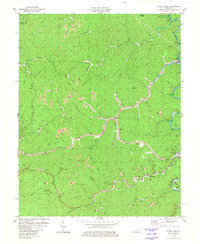
 1961 Hyden East1963 Print · USGSLeslie County during the early 1960s shows a landscape of river-valley settlements and rural schoolhouses. Researchers can locate family landmarks like the Hendrix Cem and Town Chapel, or trace the development of Buckhorn Reservoir and Wooton.
 - 1977 Map of Hazard, 1983 Print
 1977 Hazard1983 Print · USGSEastern Kentucky's coal country comes into sharp focus during the late seventies, showing the deep-set river valleys and mountain gaps that shaped regional life. Genealogists can trace family connections through river-bottom settlements like Oneida, Krypton, and Bulan or follow the Seaboard System rail lines.
 - 1980 Map of Hyden East
 1980 Hyden East1980 Print · USGSThe Leslie County coalfields are captured here in the 1980s, showcasing the intricate relationship between the Middle Fork Kentucky River and the sprawling extractive industry. Researchers can trace family homesteads near Hyden and Wooton, or locate landmarks like the Jacks Point Lookout Tower and Creek Church.
 - 1980 Map of Hyden West
 1980 Hyden West1980 Print · USGSThe Kentucky mountains around Hyden are shown during the height of ridge-top coal extraction in the early eighties. Researchers can trace family sites like Sizemore Cem or locate community landmarks including Grace Chapel and the Drive-in Theater.
End of results
Showing maps 1-11 of 11
Top cities near Hyden
Frequently asked questions
- What are the different types of historical maps available for Hyden?
- What is the oldest map of Hyden?
- Where can I purchase historical maps of Hyden for my home or office?
- Where can I download high-res historical maps of Hyden?
- Are there historical topographic maps available for Hyden?
- Is there historical aerial imagery available for Hyden?
- Where are historical maps of Hyden sourced from?