1950s Maps of McLean County, Kentucky
Explore 11 historic maps of McLean County from the 1950s. These maps offer a rare glimpse into what life looked like during the 1950s — showing old roads, neighborhoods, homes, and landmarks that have changed or disappeared over time.
Whether you're researching your family's past, planning a metal detecting trip, or studying how McLean County's landscape evolved across the 1950s, these high-resolution maps are a powerful tool for exploring the history of this region.
- Focus on a specific era: All maps on this page are from the 1950s, giving you a focused view of this time period.
- See what’s changed: Compare century-old streets, trails, and buildings to today's modern landscape using overlays and satellite layers.
- Research with precision: Use these maps for genealogy, historical research, land use analysis, or educational projects.
- View, download, or print: Maps are fully viewable online in high resolution, and can be downloaded or printed for your own records.
Start exploring McLean County's history through authentic maps from the 1950s. This is your window into the past.
McLean County, KY maps
(11)- 1952 Map of Equality, 1953 Print
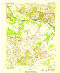
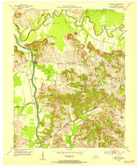 1952 Equality1953 Print · USGSThe confluence of the Green and Rough rivers comes into focus in the early 1950s, highlighting the borderlands of Ohio and McLean counties. Trace the river economy and family history through U S Lock No 1, Matanzas, and the Equality Ch.3 unique versions available
 - 1952 Map of Livermore, 1953 Print
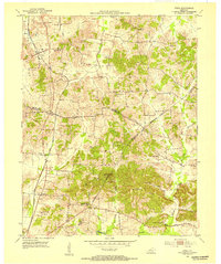
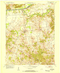
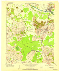 1952 Livermore1953 Print · USGSMcLean County at the start of the 1950s shows a landscape shaped by river commerce and the extractive industry. Genealogists and historians can trace family locations near Livermore, find remote burial sites like Shavers Cem, or locate the Oil Wells of the era.3 unique versions available
 - 1952 Map of Sacramento, 1953 Print
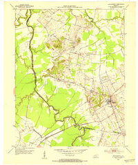 1952 Sacramento1953 Print · USGSMcLean County and the surrounding river bottoms are captured here in the early fifties, centered on the community of Sacramento. Local historians can trace early petroleum sites like an Oil Well and rural landmarks such as West Chapel and Brazzel Bridge.2 unique versions available
 - 1952 Map of Calhoun, 1954 Print
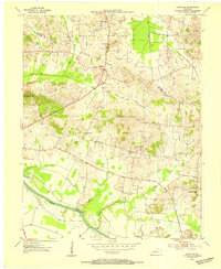
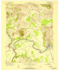 1952 Calhoun1954 Print · USGSMcLean County thrived along the banks of the winding Green River in the early fifties, where river commerce and rural agriculture met. Genealogists can trace family landmarks and community hubs like Shutts Chapel, Jewel City, and the St Sebastian Sch.3 unique versions available
 - 1952 Map of Beech Grove, 1954 Print
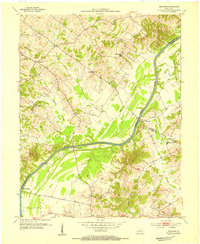
 1952 Beech Grove1954 Print · USGSThe Green River valley in the early fifties shows a rural Kentucky landscape shaped by both water and rail. Researchers can locate river-access points like Steamboat Landing, the Louisville and Nashville railroad, and local landmarks such as Onton Cem.2 unique versions available
 - 1953 Map of Utica, 1954 Print
 1953 Utica1954 Print · USGSDaviess and McLean counties come alive in the early fifties, showing a rural landscape defined by crossroad communities and oil exploration. Genealogists can trace family footprints at Atherton Cem or through local congregations like Bethlehem Ch and New Bethel Ch.3 unique versions available
 - 1953 Map of Glenville, 1954 Print
 1953 Glenville1954 Print · USGSMcLean County farming and energy extraction coincide during the early fifties near the Green River. Researchers can locate family landmarks such as Glenville Ch, Pleasant Hope Ch, and the numerous oil wells dotting the hills near Buel.2 unique versions available
 - 1953 Map of Delaware, 1954 Print
 1953 Delaware1954 Print · USGSThe Green River valley comes to life in the early fifties, showing a rural Kentucky landscape of active oil wells and riverfront landings. Genealogists can trace family names at Boston Cem and Mackey Cem or locate the old Delaware and Euterpe settlements.3 unique versions available
 - 1953 Map of Curdsville, 1954 Print
 1953 Curdsville1954 Print · USGSDaviess and McLean counties come into focus in the early 1950s, revealing a landscape defined by the winding Green River and rural industry. Researchers can trace family roots through sites like Mt St Joseph Academy, McCain Cem, and the active Oil Wells of the era.3 unique versions available
 - 1954 Map of Evansville
 1954 Evansville1954 Print · USGSThe Ohio River borderlands between Indiana and Kentucky appear here during a period of robust industrial and military growth. Genealogists and researchers can trace the rail corridors of the Illinois Central and find landmarks like US Lock and Dam No 48 or Camp Breckinridge.
 - 1957 Map of Evansville, 1969 Print
 1957 Evansville1969 Print · USGSIndiana and Kentucky meet along the Ohio River in this mid-century survey of a vital industrial and transport corridor. Genealogists and historians can trace the development of river towns like Owensboro and Newburgh or locate old rail lines like the Southern Ry.3 unique versions available
End of results
Showing maps 1-11 of 11
Top cities of McLean County
Frequently asked questions
- What are the different types of historical maps available for McLean County?
- What is the oldest map of McLean County?
- Where can I purchase historical maps of McLean County for my home or office?
- Where can I download high-res historical maps of McLean County?
- Are there historical topographic maps available for McLean County?
- Is there historical aerial imagery available for McLean County?
- Where are historical maps of McLean County sourced from?