1960s Maps of Montgomery County, Kentucky
Explore 8 historic maps of Montgomery County from the 1960s. These maps offer a rare glimpse into what life looked like during the 1960s — showing old roads, neighborhoods, homes, and landmarks that have changed or disappeared over time.
Whether you're researching your family's past, planning a metal detecting trip, or studying how Montgomery County's landscape evolved across the 1960s, these high-resolution maps are a powerful tool for exploring the history of this region.
- Focus on a specific era: All maps on this page are from the 1960s, giving you a focused view of this time period.
- See what’s changed: Compare century-old streets, trails, and buildings to today's modern landscape using overlays and satellite layers.
- Research with precision: Use these maps for genealogy, historical research, land use analysis, or educational projects.
- View, download, or print: Maps are fully viewable online in high resolution, and can be downloaded or printed for your own records.
Start exploring Montgomery County's history through authentic maps from the 1960s. This is your window into the past.
Montgomery County, KY maps
(8)- 1960 Map of Jenkins
 1960 Jenkins1960 Print · USGSEastern Kentucky and the West Virginia borderlands are captured at a mid-century peak of the coal and rail era. Trace the industrial corridors of the Chesapeake and Ohio RR through mountain hubs like Hazard and Jenkins.
 - 1960 Map of Huntington
 1960 Huntington1960 Print · USGSThe tri-state river valley thrived in the late fifties as a hub of heavy industry and Appalachian rail transit. Genealogists and historians can trace the connection between river towns like Ashland and Portsmouth or locate family homesteads near Coleman Ridge.
 - 1960 Map of Winchester
 1960 Winchester1960 Print · USGSCentral Kentucky's diverse landscape is shown here at mid-century, from the bluegrass plains to the rugged Pottsville Escarpment. Genealogists and historians can trace the rail-and-river network connecting towns like Bardstown and Stanford alongside landmarks like Lake Cumberland.
 - 1964 Map of Louisville
 1964 Louisville1964 Print · USGSThe Ohio River valley and Kentucky Bluegrass are captured in the mid-1960s, showing a region balanced between industrial growth and its agrarian roots. Genealogists and historians can trace the development of county seats like Shelbyville and Paris, or locate established institutions such as Georgetown College and Bernheim Forest.
 - 1965 Map of Mount Sterling, 1966 Print
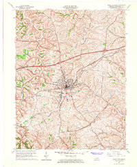 1965 Mount Sterling1966 Print · USGSMount Sterling during the mid-sixties transition shows a growing Kentucky community where the CHESAPEAKE AND OHIO railroad meets modern developments like Reid Village. Local researchers can locate historic family plots and landmarks, including Machpelah Cem, Mapleton Sch, and Klondike.2 unique versions available
 - 1965 Map of Levee, 1966 Print
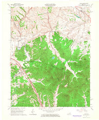 1965 Levee1966 Print · USGSMid-century Montgomery and Clark counties are captured here as traditional farming communities meet the sharp hills of the Knobs. Researchers can trace ancestral locations like Kiddville, Indian Fields, and the Willoughby Cem near Camargo.
 - 1965 Map of Sideview, 1966 Print
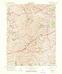 1965 Sideview1966 Print · USGSThe rural borders of Clark and Bourbon counties are captured here in the mid-1960s, a landscape of winding creeks and historic crossroads. Genealogists and local historians can trace family sites like Prewitt Cem and early settlements including Sideview and Wades Mill.2 unique versions available
 - 1965 Map of Hedges, 1966 Print
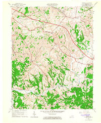 1965 Hedges1966 Print · USGSEastern Clark County's ridge-and-hollow settlements are captured here in the mid-1960s as modern infrastructure began to cross traditional farmland. Genealogists can trace family connections through numerous named cemeteries and country churches like Ephesus Ch, or locate vanished post offices at Rightangle, Rabbit Town, and Schollsville.2 unique versions available
End of results
Showing maps 1-8 of 8
Top cities of Montgomery County
Frequently asked questions
- What are the different types of historical maps available for Montgomery County?
- What is the oldest map of Montgomery County?
- Where can I purchase historical maps of Montgomery County for my home or office?
- Where can I download high-res historical maps of Montgomery County?
- Are there historical topographic maps available for Montgomery County?
- Is there historical aerial imagery available for Montgomery County?
- Where are historical maps of Montgomery County sourced from?