Old Maps of Ohio County, Kentucky for Hiking & Exploration
Hike through history with 158 historic maps of Ohio County. Explore old trails, ghost towns, and forgotten backroads — perfect for outdoor adventurers and local explorers.
- Rediscover forgotten places: Map out old mining camps, roads, and footpaths that no longer exist on modern maps.
- Layer with modern tools: Combine with LiDAR or satellite views to plan hikes through historical terrain.
- Made for exploration: Popular among hikers, overlanders, and local history lovers.
Use these maps to find adventure and explore the hidden past of Ohio County.
Ohio County, KY maps
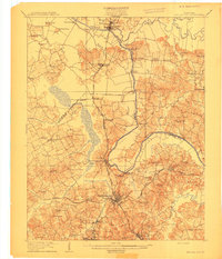
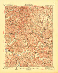
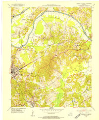
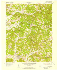
(158)- 1906 Map of Sutherland
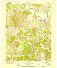
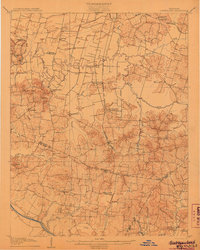 1906 Sutherland1906 Print · USGSDaviess and McLean counties come into focus at the start of the twentieth century, when the rail lines and river forks dictated the pace of rural life. Genealogists and local historians can trace early homes and landmarks near Utica, St Martins Church, and the distinctive Backbone Ridge.3 unique versions available
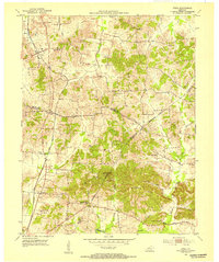
 - 1907 Map of Whitesville, 1962 Print
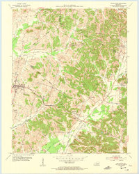
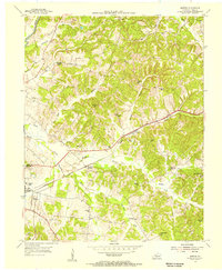
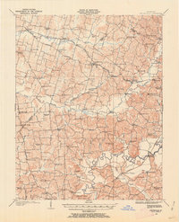 1907 Whitesville1962 Print · USGSDaviess and Ohio counties are captured here in the early 1900s, showcasing a rural landscape of crossroads settlements and river fords. Genealogists can locate specific family-named landmarks and community hubs like Hewlett's Store, Tanglewood School, and Little Zion Church.
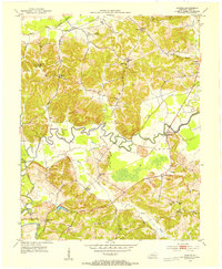
 - 1909 Map of Whitesville
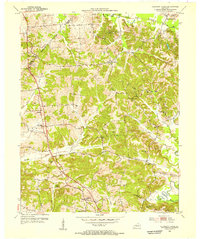
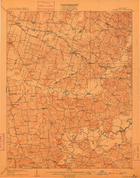 1909 Whitesville1909 Print · USGSKentucky's rural interior comes into focus here during the early 1900s, showing a landscape of small farming communities and river crossings. Genealogists can trace family roots through dozens of local landmarks like Whalen PO, St Thomas Church, and Berry School.2 unique versions available
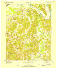
 - 1909 Map of Hartford
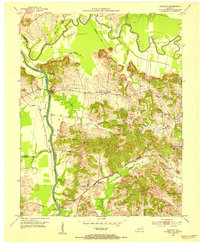
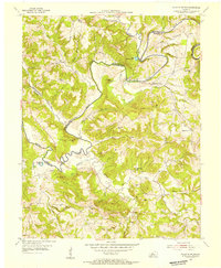
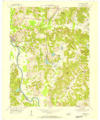
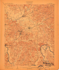 1909 Hartford1909 Print · USGSOhio County and the Green River valley are captured here just after the turn of the century, when river ferries and coal rail lines drove the local economy. Trace the old ferry crossings like Stroud Ferry and mining centers at Taylor Mines and Render.2 unique versions available
 - 1909 Map of Central City
 1909 Central City1909 Print · USGSWestern Kentucky's coal and river country comes alive in this early century survey of Muhlenberg, McLean, and Ohio counties. Researchers can trace historic river crossings at Kinchloe Ferry and Knotts Ferry or locate old community hubs like Shavers Chapel and Moorman.3 unique versions available
 - 1911 Map of Dunmor
 1911 Dunmor1911 Print · USGSMuhlenberg and Butler Counties are shown here just before the Great War, when river ferries and small rural schools anchored local life. Genealogists can trace family footprints at Mining City, Ebenezer Church, and the river landings near Skilesville.
 - 1914 Map of Dunmor
 1914 Dunmor1914 Print · USGSWestern Kentucky in the early twentieth century is defined by the river-borne trade of the Green River and the rural industry of the Mud River Mine. Genealogists and historians can trace defunct post offices like Boston Herschel PO and family-named crossings including Arnolds Bridge and Doolins Ferry.
 - 1925 Map of Spring Lick
 1925 Spring Lick1925 Print · USGSButler and Ohio counties are shown here in the mid-1920s, featuring a landscape of rural schoolhouses and river bends. Genealogists can trace family connections through sites like Flener Chapel, Whiteoak School, and the Illinois Central rail stops.2 unique versions available
 - 1932 Map of Fordsville
 1932 Fordsville1932 Print · USGSThe hill country of Ohio and Breckinridge Counties is captured here in the early thirties as the railroad age peaked. Researchers can trace family sites at Barretts Ferry PO Davidson Sta, Glen Dean, and the many schools like Fallen Rock Sch.
 - 1952 Map of Equality, 1953 Print
 1952 Equality1953 Print · USGSThe confluence of the Green and Rough rivers comes into focus in the early 1950s, highlighting the borderlands of Ohio and McLean counties. Trace the river economy and family history through U S Lock No 1, Matanzas, and the Equality Ch.3 unique versions available
 - 1952 Map of Livermore, 1953 Print
 1952 Livermore1953 Print · USGSMcLean County at the start of the 1950s shows a landscape shaped by river commerce and the extractive industry. Genealogists and historians can trace family locations near Livermore, find remote burial sites like Shavers Cem, or locate the Oil Wells of the era.3 unique versions available
 - 1953 Map of Philpot, 1954 Print
 1953 Philpot1954 Print · USGSDaviess and Ohio counties in the early fifties show a landscape of oil production and rural community life. Trace family roots at Karns Grove Ch or follow the Illinois Central Line past Philpot and Whitesville.
 - 1953 Map of Central City West, 1954 Print
 1953 Central City West1954 Print · USGSWestern Muhlenberg County is documented here in the early fifties, showing the area as the local economy shifted toward industrial coal production. Genealogists can trace family roots through numerous country landmarks like Shavers Chapel, Midland Sch, and the Evergreen Cem near the Green River.
 - 1953 Map of Central City East, 1954 Print
 1953 Central City East1954 Print · USGSMuhlenberg County in the early 1950s was a bustling hub of rail transport and coal production along the river. Genealogists can trace family roots through several local landmarks like Richardson Chapel, Fairmount Cem, and the communities of Cleaton and Ceralvo.
 - 1953 Map of Utica, 1954 Print
 1953 Utica1954 Print · USGSDaviess and McLean counties come alive in the early fifties, showing a rural landscape defined by crossroad communities and oil exploration. Genealogists can trace family footprints at Atherton Cem or through local congregations like Bethlehem Ch and New Bethel Ch.3 unique versions available
 - 1953 Map of Dundee, 1954 Print
 1953 Dundee1954 Print · USGSOhio County in the early fifties is shown here as a landscape of river-bottom farms and active oil exploration. Researchers can locate family landmarks like Patton Cem, trace the oxbows of the Rough River, or find the old Sugar Grove School.2 unique versions available
 - 1953 Map of South Hill, 1954 Print
 1953 South Hill1954 Print · USGSButler County in the early fifties was a landscape of river-bend settlements and active extraction. Genealogists and historians can locate numerous family burial grounds like Webster Cem and Rone Cem, as well as the sites of Hickory Stand Sch and the southern Oil Field.2 unique versions available
 - 1953 Map of Rochester, 1954 Print
 1953 Rochester1954 Print · USGSThe Green River valley in the early fifties shows a bustling network of river towns and rural school districts at the junction of three counties. Researchers can trace family sites near Rochester, find old schoolhouses like Mud River Mine Sch, or locate the Lock No 3 river works.2 unique versions available
 - 1953 Map of Whitesville, 1955 Print
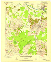
 1953 Whitesville1955 Print · USGSDaviess and Ohio counties in the early fifties reveal a landscape of active energy production and rail-dependent commerce. Local historians can trace the Illinois Central line through Reynolds Sta or locate family sites at St Thomas Cem and Old Panther Ch.
 - 1953 Map of Pleasant Ridge, 1955 Print
 1953 Pleasant Ridge1955 Print · USGSDaviess and Ohio Counties are shown here in the early fifties, a time when small rural settlements and active oil fields shared the landscape. Researchers can trace old family sites and country landmarks like Shinkle Chapel, Clear Run Sch, and French Cem.
 - 1953 Map of Falls Of Rough, 1955 Print
 1953 Falls Of Rough1955 Print · USGSThe Rough River valley in the early fifties shows a landscape of ridge-top schools and secluded family cemeteries. Researchers can trace ancestral locations at Yeaman or Tousey and find rural landmarks like Lone Hill Sch and Shady Grove Ch.
 - 1953 Map of Fordsville, 1955 Print
 1953 Fordsville1955 Print · USGSMid-century Kentucky hill country comes alive here as the Illinois Central railroad connects small rural communities and a growing petroleum industry. Genealogists can trace family roots through landmarks like Boiling Chapel, Ellmitch, and the Wedding Cemetery.2 unique versions available
 - 1954 Map of Evansville
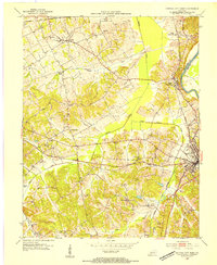
 1954 Evansville1954 Print · USGSThe Ohio River borderlands between Indiana and Kentucky appear here during a period of robust industrial and military growth. Genealogists and researchers can trace the rail corridors of the Illinois Central and find landmarks like US Lock and Dam No 48 or Camp Breckinridge.
 - 1954 Map of Horton, 1955 Print
 1954 Horton1955 Print · USGSOhio County's coal and rail landscape is captured here in the mid-fifties as industrial mining began to reshape the rural hills. Genealogists and researchers can locate family landmarks like Milton Taylor Cem, several rural school sites including Horton Sch, and the ILLINOIS CENTRAL rail stops.
 - 1954 Map of Paradise, 1955 Print
 1954 Paradise1955 Print · USGSWestern Kentucky's river and rail economy is captured here in the mid-fifties, centered on the winding Green River. Genealogists and historians can trace family locations near Paradise, the Airdrie Iron Furnace, and country churches like Taylortown Ch.
Showing maps 1-25 of 158
Top cities of Ohio County
- Beaver Dam historical maps
- Hartford historical maps
- Fordsville historical maps
- McHenry historical maps
- Centertown historical maps
- Rockport historical maps
Frequently asked questions
- What are the different types of historical maps available for Ohio County?
- What is the oldest map of Ohio County?
- Where can I purchase historical maps of Ohio County for my home or office?
- Where can I download high-res historical maps of Ohio County?
- Are there historical topographic maps available for Ohio County?
- Is there historical aerial imagery available for Ohio County?
- Where are historical maps of Ohio County sourced from?