1900s (20th Century) Maps of Rockport, Kentucky
Explore 12 historic maps of Rockport from the 1900s (20th Century). These maps offer a rare glimpse into what life looked like during the 1900s — showing old roads, neighborhoods, homes, and landmarks that have changed or disappeared over time.
Whether you're researching your family's past, planning a metal detecting trip, or studying how Rockport's landscape evolved across the 1900s, these high-resolution maps are a powerful tool for exploring the history of this region.
- Focus on a specific era: All maps on this page are from the 1900s, giving you a focused view of this time period.
- See what’s changed: Compare century-old streets, trails, and buildings to today's modern landscape using overlays and satellite layers.
- Research with precision: Use these maps for genealogy, historical research, land use analysis, or educational projects.
- View, download, or print: Maps are fully viewable online in high resolution, and can be downloaded or printed for your own records.
Start exploring Rockport's history through authentic maps from the 1900s. This is your window into the past.
Rockport, KY maps
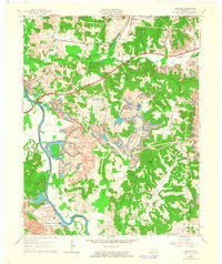
(12)- 1909 Map of Hartford
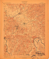 1909 Hartford1909 Print · USGSOhio County and the Green River valley are captured here just after the turn of the century, when river ferries and coal rail lines drove the local economy. Trace the old ferry crossings like Stroud Ferry and mining centers at Taylor Mines and Render.2 unique versions available
 - 1909 Map of Central City
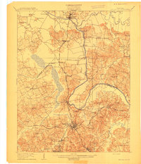 1909 Central City1909 Print · USGSWestern Kentucky's coal and river country comes alive in this early century survey of Muhlenberg, McLean, and Ohio counties. Researchers can trace historic river crossings at Kinchloe Ferry and Knotts Ferry or locate old community hubs like Shavers Chapel and Moorman.3 unique versions available
 - 1953 Map of Central City East, 1954 Print
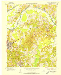 1953 Central City East1954 Print · USGSMuhlenberg County in the early 1950s was a bustling hub of rail transport and coal production along the river. Genealogists can trace family roots through several local landmarks like Richardson Chapel, Fairmount Cem, and the communities of Cleaton and Ceralvo.
 - 1954 Map of Evansville
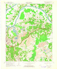
 1954 Evansville1954 Print · USGSThe Ohio River borderlands between Indiana and Kentucky appear here during a period of robust industrial and military growth. Genealogists and researchers can trace the rail corridors of the Illinois Central and find landmarks like US Lock and Dam No 48 or Camp Breckinridge.
 - 1954 Map of Paradise, 1955 Print
 1954 Paradise1955 Print · USGSWestern Kentucky's river and rail economy is captured here in the mid-fifties, centered on the winding Green River. Genealogists and historians can trace family locations near Paradise, the Airdrie Iron Furnace, and country churches like Taylortown Ch.
 - 1957 Map of Evansville, 1969 Print
 1957 Evansville1969 Print · USGSIndiana and Kentucky meet along the Ohio River in this mid-century survey of a vital industrial and transport corridor. Genealogists and historians can trace the development of river towns like Owensboro and Newburgh or locate old rail lines like the Southern Ry.3 unique versions available
 - 1961 Map of Evansville
 1961 Evansville1961 Print · USGSThe Ohio River valley and its surrounding coalfields are captured here during the late fifties and early sixties. Trace the industrial rail networks of the Illinois Central RR and explore regional landmarks like Mammoth Cave National Park and Angel Mounds State Memorial.2 unique versions available
 - 1963 Map of Paradise, 1964 Print
 1963 Paradise1964 Print · USGSCoal and power define this river landscape in the early sixties, showing the massive industrial shift near the Green River. Researchers can trace old family sites like Maddux Cemetery alongside the rising TVA Powerplant and the village of Paradise.2 unique versions available
 - 1963 Map of Central City East, 1965 Print
 1963 Central City East1965 Print · USGSMuhlenberg County was a hub of coal production and rail transport in the early sixties. Genealogists and researchers can trace local families through Rose Hill Cem and Stewart Cem, or locate mining heritage near Cleaton and the Strip Mines.3 unique versions available
 - 1981 Map of Beaver Dam, 1984 Print
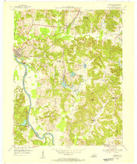
 1981 Beaver Dam1984 Print · USGSThe Western Kentucky coal and river country comes into focus in the early 1980s as industry and recreation reshape the land. Researchers can trace family roots and old routes through Morgantown, Beaver Dam, and the early footprints of Mammoth Cave National Park.
 - 1983 Map of Madisonville, 1984 Print
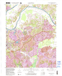
 1983 Madisonville1984 Print · USGSThe Western Kentucky coalfields and river valleys come into focus in the early eighties as the rail-and-river economy matured. Genealogists can trace family footprints across Dawson Springs, Mortons Gap, and Slaughters, or locate landmarks like Shake Rag Hills and Lake Malone.
 - 1997 Map of Central City East, 1999 Print
 1997 Central City East1999 Print · USGSMuhlenberg County's coal country and the Green River valley are shown in the 1990s as industry reshapes the terrain. Genealogists can locate family landmarks like Rose Hill Cem and Green River Chapel or trace the early layouts of Cleaton and Martwick.
End of results
Showing maps 1-12 of 12
Top cities near Rockport
- Central City historical maps
- Greenville historical maps
- Beaver Dam historical maps
- Hartford historical maps
- Livermore historical maps
- Powderly historical maps
See more
Frequently asked questions
- What are the different types of historical maps available for Rockport?
- What is the oldest map of Rockport?
- Where can I purchase historical maps of Rockport for my home or office?
- Where can I download high-res historical maps of Rockport?
- Are there historical topographic maps available for Rockport?
- Is there historical aerial imagery available for Rockport?
- Where are historical maps of Rockport sourced from?