1950s Maps of Scott County, Kentucky
Explore 15 historic maps of Scott County from the 1950s. These maps offer a rare glimpse into what life looked like during the 1950s — showing old roads, neighborhoods, homes, and landmarks that have changed or disappeared over time.
Whether you're researching your family's past, planning a metal detecting trip, or studying how Scott County's landscape evolved across the 1950s, these high-resolution maps are a powerful tool for exploring the history of this region.
- Focus on a specific era: All maps on this page are from the 1950s, giving you a focused view of this time period.
- See what’s changed: Compare century-old streets, trails, and buildings to today's modern landscape using overlays and satellite layers.
- Research with precision: Use these maps for genealogy, historical research, land use analysis, or educational projects.
- View, download, or print: Maps are fully viewable online in high resolution, and can be downloaded or printed for your own records.
Start exploring Scott County's history through authentic maps from the 1950s. This is your window into the past.
Scott County, KY maps
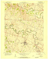
(15)- 1950 Map of Lexington West, 1952 Print
 1950 Lexington West1952 Print · USGSThe Bluegrass region around Lexington is captured here in the mid-century, showcasing the era's legendary horse farms and expanding urban footprint. Researchers can trace the grounds of Calumet Farm, locate the Kentucky House of Reform, and explore the 1950s layout of the University of Kentucky.
 - 1952 Map of Midway, 1955 Print
 1952 Midway1955 Print · USGSMidway and the surrounding Bluegrass countryside are captured here in the early fifties as the Louisville and Nashville rail line still pulsed through the town center. Researchers can trace the exact locations of Spring Station, the Orphans Sch, and St Francis Mission amidst the winding creeks.
 - 1953 Map of Sadieville, 1954 Print
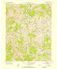
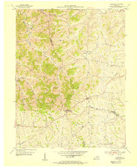
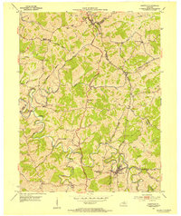 1953 Sadieville1954 Print · USGSNorthern Scott County during the early 1950s was a landscape of deep creek valleys and ridgeline roads centered on the Southern rail line. Researchers can locate family landmarks such as Odd Fellows Cem and rural centers like Stonewall or Hinton.
 - 1953 Map of Breckinridge, 1955 Print
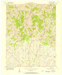
 1953 Breckinridge1955 Print · USGSHarrison County and Scott County life in the early 1950s is defined by small agricultural hubs and a intricate network of creek-fed valleys. Researchers can trace the rural communities of Rutland and Connersville or locate family history at White Oak Ch and Beard Cem.
 - 1953 Map of Stamping Ground, 1955 Print
 1953 Stamping Ground1955 Print · USGSThe rural landscape of Scott and Owen counties in the early fifties is defined by small crossroads hamlets and the path of the Frankfort and Cincinnati railroad. Genealogists can trace family footprints through several local burial sites including Minorsville Cem, Riddle Cem, and Cedar Grove Cem.3 unique versions available
 - 1953 Map of New Columbus, 1955 Print
 1953 New Columbus1955 Print · USGSOwen County in the early fifties is mapped here in detail, showing a landscape defined by the winding Eagle Creek and rural hamlets. Researchers can trace family history through numerous remote sites like Hudson Abbot Cem, New Columbus, and Caney Creek Ch.3 unique versions available
 - 1953 Map of Delaplain, 1955 Print
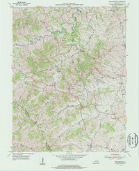
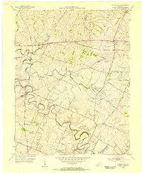
 1953 Delaplain1955 Print · USGSScott County in the early fifties is captured here as a network of ridge-top roads and creek-side hamlets. Genealogists and historians can trace family locations near Oxford, Salem Ch, or the County Farm along the Southern rail line.
 - 1954 Map of Midway, 1955 Print
 1954 Midway1955 Print · USGSMid-century Woodford and Scott Counties are captured here as a landscape of rail-connected towns and winding creek valleys. Genealogists and researchers can trace local landmarks like the Orphans Sch, the St Francis Mission, and the crossroads at White Sulphur.4 unique versions available
 - 1954 Map of Versailles, 1955 Print
 1954 Versailles1955 Print · USGSMid-century Versailles and Woodford County are captured here during a period of steady growth and local industrial activity. Researchers can trace family-named sites and vanished institutions like Hunter Town, Simmons High Sch, and the Phosphate Strip Mine.
 - 1954 Map of Leesburg, 1955 Print
 1954 Leesburg1955 Print · USGSThe rural borderlands of Harrison, Scott, and Bourbon counties come to life in the mid-1950s. Genealogists and historians can trace family locations near Leesburg and Oxford, or locate community landmarks like Beards Ch and Hinton Cem.3 unique versions available
 - 1954 Map of Centerville, 1955 Print
 1954 Centerville1955 Print · USGSMid-century central Kentucky comes alive in this survey of the Bluegrass region at the intersection of Scott, Bourbon, and Fayette counties. Trace the paths of historic hamlets like Newtown and New Zion, or locate the Man-O-War Monument and the old Lemons Mill.4 unique versions available
 - 1954 Map of Georgetown, 1955 Print
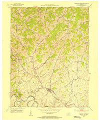
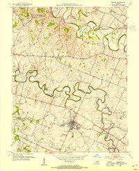
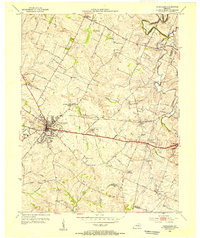
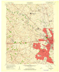
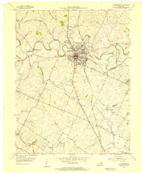 1954 Georgetown1955 Print · USGSScott County enters the mid-fifties as a hub of education and transport centered on the crossing of major rail lines and the winding Elkhorn Creek. Researchers can trace the grounds of Georgetown College, locate Paynes Depot, or find rural landmarks like Bethel Ch and Cardome Academy.
 - 1955 Map of Lexington West, 1956 Print
 1955 Lexington West1956 Print · USGSMid-century Lexington and its famed horse country are revealed in this detailed survey as the city expands westward. Researchers can trace the footprints of legendary estates like Calumet Farm, the original University of Kentucky campus, and the U S Veterans Hospital.
 - 1956 Map of Louisville, 1971 Print
 1956 Louisville1971 Print · USGSThe Ohio River valley and the Kentucky Bluegrass are captured here during a period of rapid mid-century growth and industrial activity. Genealogists and historians can trace rail-centered towns and military land use at Fort Knox and the Jefferson Proving Ground.2 unique versions available
 - 1959 Map of Lexington West, 1961 Print
 1959 Lexington West1961 Print · USGSMid-century Lexington and the surrounding horse country are captured here just as suburban expansion began to meet historic Bluegrass estates. Researchers can trace legendary grounds like Calumet Farm alongside the growing University of Kentucky and the Keeneland Race Course.
End of results
Showing maps 1-15 of 15
Top cities of Scott County
- Georgetown historical maps
- Stamping Ground historical maps
- Sadieville historical maps
- Zion Hill historical maps
Frequently asked questions
- What are the different types of historical maps available for Scott County?
- What is the oldest map of Scott County?
- Where can I purchase historical maps of Scott County for my home or office?
- Where can I download high-res historical maps of Scott County?
- Are there historical topographic maps available for Scott County?
- Is there historical aerial imagery available for Scott County?
- Where are historical maps of Scott County sourced from?