1900s (20th Century) Maps of Lille, Grand Isle
Explore 6 historic maps of Lille from the 1900s (20th Century). These maps offer a rare glimpse into what life looked like during the 1900s — showing old roads, neighborhoods, homes, and landmarks that have changed or disappeared over time.
Whether you're researching your family's past, planning a metal detecting trip, or studying how Lille's landscape evolved across the 1900s, these high-resolution maps are a powerful tool for exploring the history of this region.
- Focus on a specific era: All maps on this page are from the 1900s, giving you a focused view of this time period.
- See what’s changed: Compare century-old streets, trails, and buildings to today's modern landscape using overlays and satellite layers.
- Research with precision: Use these maps for genealogy, historical research, land use analysis, or educational projects.
- View, download, or print: Maps are fully viewable online in high resolution, and can be downloaded or printed for your own records.
Start exploring Lille's history through authentic maps from the 1900s. This is your window into the past.
Lille, Grand Isle maps
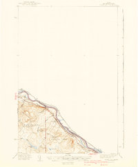
(6)- 1938 Map of Grand Isle, 1977 Print
 1938 Grand Isle1977 Print · USGSUpper Aroostook County life in the late 1930s is anchored here along the river border with New Brunswick. Genealogists and local historians can trace family locations near St David, Lille, and the Doucette Sch along the Bangor and Aroostook line.
 - 1940 Map of Grand Isle
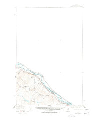
 1940 Grand Isle1940 Print · USGSThe northern boundary of Maine along the St John River is captured here during the 1940s, showing a landscape defined by riverside settlements and rail. Trace the family-named landmarks and rural hubs of the era, from St David and Lille to the isolated Doucotte Sch.3 unique versions available
 - 1962 Map of Edmundston, 1966 Print
 1962 Edmundston1966 Print · USGSThe international borderlands of northern Maine and Canada come alive here during the early sixties, centered on the river-and-rail economies of the day. Genealogists and historians can trace the paths of the Bangor and Aroostook railroad through river towns like Fort Kent and St Agatha.2 unique versions available
 - 1975 Map of Grand Isle SE, 1981 Print
 1975 Grand Isle SE1981 Print · USGSThe international border along the St. John River comes into sharp focus in the mid-1970s, showing the agricultural long lots of the Acadian valley. Genealogists can trace family homesteads near Lille, Ste-Anne-De-Madawaska, and the winding Quisibis River.
 - 1986 Map of Lille
 1986 Lille1986 Print · USGSThe international border along the St. John River comes alive in the mid-1980s, documenting the shared geography of Maine and New Brunswick. Genealogists and historians can trace riverside settlements like Lille and Sainte-Anne-de-Madawaska or locate La Grande Island and family-named landmarks like Montagne-des-Therrien.
 - 1994 Map of Madawaska
 1994 Madawaska1994 Print · USGSThe St John Valley in the 1990s remained a unique cultural crossroads of Maine and New Brunswick, centered on the river and the rails. Genealogists and historians can trace family-named settlements like Violette Settlement or explore the shores of Eagle Lake and Long Lake.
End of results
Showing maps 1-6 of 6
Frequently asked questions
- What are the different types of historical maps available for Lille?
- What is the oldest map of Lille?
- Where can I purchase historical maps of Lille for my home or office?
- Where can I download high-res historical maps of Lille?
- Are there historical topographic maps available for Lille?
- Is there historical aerial imagery available for Lille?
- Where are historical maps of Lille sourced from?