Old Maps of The Ridge, Bridgton for Academic Research
Study the evolution of The Ridge with 16 high-resolution historic maps. Whether you're teaching, researching, or modeling changes in land use, these maps provide essential visual documentation of urban, environmental, and geographic change.
- Analyze long-term change: Track patterns in development, transportation, and natural features.
- Ideal for environmental or urban studies: Support academic projects with primary historical map data.
- Use in the classroom or lab: Educators and researchers rely on these maps to bring historical context to life.
These maps are a powerful tool for teaching, research, and visualizing how The Ridge has changed over the decades.
The Ridge, Bridgton maps
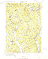
(16)- 1896 Map of Norway
 1896 Norway1896 Print · USGSOxford County in the late nineteenth century was a land of timber and steam, where the Grand Trunk met busy lakeside landings. Trace old transport routes between Norway, the mills at Bolsters Mills, and the Steamer Landing on Long Lake.8 unique versions available
 - 1946 Map of Norway, 1955 Print
 1946 Norway1955 Print · USGSMid-century Oxford County is defined by its deep lake system and timber-driven river settlements before the arrival of modern interstates. Genealogists and historians can trace family plots at Bisbeetown Cem, locate the old Lewis Sch, and find historical hubs like Scribners Mill and the Fairgrounds.4 unique versions available
 - 1949 Map of Norway
 1949 Norway1949 Print · USGSOxford County and the upper Cumberland lakes region are shown here in the mid-forties, capturing the era of small-town mills and rail-fed industry. Genealogists and historians can trace family locations through Bisbeetown Cem, Scribners Mill, and the historic Bell Hill Meeting House.2 unique versions available
 - 1950 Map of Lewiston
 1950 Lewiston1950 Print · USGSThe Maine and New Hampshire borderlands come alive in this post-war survey of the White Mountains and Androscoggin valley. Genealogists and historians can trace rail lines like the Maine Central Railroad and find high-altitude landmarks from Mount Washington to Bretton Woods.2 unique versions available
 - 1956 Map of Lewiston, 1975 Print
 1956 Lewiston1975 Print · USGSThe Northern New England interior is documented here in the mid-fifties, from the industrial Androscoggin River to the high peaks of the White Mountains. Trace the Grand Trunk Railway through mountain passes or locate family landmarks near Sabbathday Lake and Bretton Woods.
 - 1961 Map of Lewiston
 1961 Lewiston1961 Print · USGSWestern Maine and the White Mountains appear here during the early sixties, showing the industrial river towns and vast timberlands before the modern interstate era. Genealogists and historians can trace the Grand Trunk RR through Berlin or locate landmarks like Old Speck Mountain and Elephant Mountain.
 - 1962 Map of Lewiston
 1962 Lewiston1962 Print · USGSThe industrial river valleys and high peaks of Maine and New Hampshire define the region in the early sixties. Trace the rail-and-river network from Lewiston to the White Mountains, passing through mill towns like Berlin and Rumford.
 - 1969 Map of Lewiston
 1969 Lewiston1969 Print · USGSThe northern New England highlands come into focus during the mid-fifties, showing the vital rail and river networks connecting industrial centers to the deep woods. Researchers can trace the path of the Grand Trunk RR or locate landmarks like Mt Washington and Rangeley Lake.
 - 1983 Map of Bridgton, 1984 Print
 1983 Bridgton1984 Print · USGSThe Maine lakes region in the early eighties is captured here, centered on the village of Bridgton between Long Lake and Highland Lake. Genealogists can trace family lines through several burial grounds like Ridge Cem and Trafton Cem or locate the old Maple Ridge Sch.
 - 1986 Map of Lewiston
 1986 Lewiston1986 Print · USGSMaine’s industrial river valleys and western mountain foothills are captured here in the mid-eighties as rail and road networks tied the region together. Genealogists and historians can trace the development of mill towns and lakefront settlements from Lisbon to Bethel, following the Androscoggin River and the path of the Maine Central Railroad.2 unique versions available
 - 2000 Map of Bridgton, 2001 Print
 2000 Bridgton2001 Print · USGSThe Bridgton and Harrison area at the start of the new millennium is defined by its iconic lakes and deep-rooted summer camp culture. Researchers can locate numerous family burial sites like Finnish Cem and Trafton Cem or trace the early development of Sandy Creek and North Bridgton.
 - 2011 Map of Bridgton, 2011 Print
 2011 Bridgton2011 Print · USGSCovers The Ridge, including Bridgton, Naples, and other nearby areas
 - 2014 Map of Bridgton, 2014 Print
 2014 Bridgton2014 Print · USGSCovers The Ridge, including Bridgton, Naples, and other nearby areas
 - 2018 Map of Bridgton, 2018 Print
 2018 Bridgton2018 Print · USGSCovers The Ridge, including Bridgton, Naples, and other nearby areas
 - 2021 Map of Bridgton, 2021 Print
 2021 Bridgton2021 Print · USGSCovers The Ridge, including Bridgton, Naples, and other nearby areas
 - 2024 Map of Bridgton, 2024 Print
 2024 Bridgton2024 Print · USGSMaine's Lakes Region flourishes in the early twenty-first century, showing the established communities of Bridgton and Harrison along the shores of Long Lake. Genealogists can trace local family history through numerous sites like Sandy Creek Cem and the Finnish Cem.
End of results
Showing maps 1-16 of 16
Frequently asked questions
- What are the different types of historical maps available for The Ridge?
- What is the oldest map of The Ridge?
- Where can I purchase historical maps of The Ridge for my home or office?
- Where can I download high-res historical maps of The Ridge?
- Are there historical topographic maps available for The Ridge?
- Is there historical aerial imagery available for The Ridge?
- Where are historical maps of The Ridge sourced from?