Old Maps of Great Pond, Maine
Explore 54 old maps of Great Pond, spanning from 1929 to today. These high-resolution historic maps reveal how streets, neighborhoods, landmarks, and natural features evolved over time — perfect for genealogy, metal detecting, research, and local history exploration.
What you can do with these maps:
- See how Great Pond changed over time: Compare historical maps to modern-day views to trace roads, homesites, rail lines & more.
- View detailed metadata: Each map includes creators, publishers, year, scale, and archive source.
- Overlay maps with satellite & LiDAR: Visualize the past alongside modern tools to explore terrain & human change.
- Trusted historical sources: Maps sourced from the USGS, Library of Congress, and other archives.
- Access maps your way: View online, download high-res files, or order prints for personal or research use.
Start exploring old maps of Great Pond to uncover forgotten places, hidden landmarks, and the deep history beneath your feet.
Great Pond, ME maps
(54)- 1929 Map of Great Pond
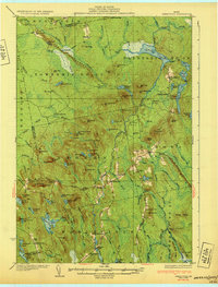
 1929 Great Pond1929 Print · USGSThe rural interior of Hancock County is captured here in the late twenties during a period of remote timber camps and small mountain schools. Researchers can locate long-standing landmarks such as Archer's Corners, Rebel Hill Sch, and the isolated Rackliff Camp.
 - 1929 Map of Lead Mountain
 1929 Lead Mountain1929 Print · USGSThe Maine backcountry near the Hancock and Washington County line is shown here in the late twenties, dominated by timberlands and glacial lakes. Genealogists and historians can locate remote outposts like Jacobs Camp, the Howe Farm, and the trails surrounding Lead Mountain.
 - 1931 Map of Saponac
 1931 Saponac1931 Print · USGSThe Maine wilderness of the early thirties is captured here before modern development, spanning the border of Penobscot and Hancock counties. Researchers can trace rural life through the locations of the Greenfield Cemetery, the Morrison Mill, and several district schools like School No 1.
 - 1932 Map of Nicatous Lake
 1932 Nicatous Lake1932 Print · USGSNicatous Lake and the surrounding Maine wilderness are captured here in the early 1930s, when private sporting retreats and seasonal camps dotted the shoreline. Genealogists and local historians can trace specific locations like the Explorers Club, Adler Tavern Camp, and Sullivan Camp.4 unique versions available
 - 1932 Map of Lead Mountain
 1932 Lead Mountain1932 Print · USGSThe Maine timberlands and the historic Air Line Road are captured here in the early thirties, showcasing a landscape of isolated logging camps and remote lakes. Researchers can locate family-named sites like Howe Farm Camp, the settlements of Deblois and Beddington, and the Fire Tower atop Lead Mountain.5 unique versions available
 - 1932 Map of Great Pond
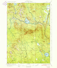
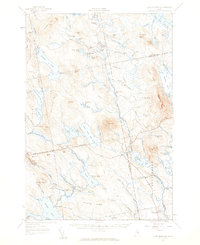
 1932 Great Pond1932 Print · USGSHancock and Penobscot Counties are captured here in the early thirties, showcasing the timberlands and small settlements along the Airline Road. Local historians can trace family roots through sites like the Goodwin School, Archers Corners, and North Mariaville.4 unique versions available
 - 1934 Map of Saponac
 1934 Saponac1934 Print · USGSPenobscot County was a landscape of small mill towns and mountain ridges in the 1930s. Researchers can locate early district schools like Longfellow Sch, industrial sites such as Morrison Mill, and family landmarks including Crocker Turn.3 unique versions available
 - 1934 Map of Nicatous Lake
 1934 Nicatous Lake1934 Print · USGSHancock County was a landscape of remote sporting camps and timber trails in the early 1930s. Genealogists and historians can trace old sites like Poplar Tavern Camp, the Nicatous Club, and No 2 Camp set among landmarks like Duck Mtn.4 unique versions available
 - 1948 Map of Bangor
 1948 Bangor1948 Print · USGSThe Maine coast and its industrial river valleys are captured here shortly after the war, showing the vital shipping and rail hubs of the late 1940s. Genealogists and historians can trace the tracks of the Maine Central RR connecting Bangor, Augusta, and Old Town.
 - 1954 Map of Millinocket, 1968 Print
 1954 Millinocket1968 Print · USGSMaine's North Woods and the Penobscot Valley are captured here during the mid-century era of logging and rail dominance. You can trace the path of the Bangor and Aroostook Railroad through timber towns like Millinocket, Mattawamkeag, and Silver Ridge.3 unique versions available
 - 1956 Map of Bangor, 1966 Print
 1956 Bangor1966 Print · USGSMid-century Maine comes alive in this survey of the rugged coast and river valleys during the 1950s. Genealogists and historians can trace the vital rail corridors of the Maine Central RR connecting timber towns like Old Town to the coast at Bar Harbor.3 unique versions available
 - 1957 Map of Great Pond, 1959 Print
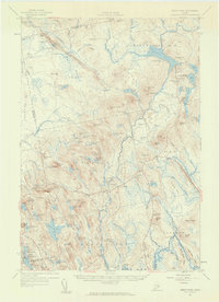 1957 Great Pond1959 Print · USGSHancock County's interior townships are shown here in the late fifties as military recreation and training sites integrated with traditional rural settlements. Researchers can locate the Hadley Cem and several community schools like Monticello Sch and Caruso Sch.4 unique versions available
 - 1957 Map of Saponac, 1959 Print
 1957 Saponac1959 Print · USGSPenobscot and Hancock counties are shown here in the late fifties, during a period of rural stability in the Maine north woods. Researchers can locate family landmarks like Mt Repose Cem, the Thirty-Nine Tannery, and the Corner Sch in Lowell.4 unique versions available
 - 1957 Map of Lead Mountain, 1959 Print
 1957 Lead Mountain1959 Print · USGSThe wild lake country of Down East Maine is shown here in the late fifties, featuring the scattered outposts and high ridges of Washington and Hancock Counties. Genealogists and researchers can trace local landmarks like Beddington, Dog Corners, and the prominent Lookout Tower atop Lead Mtn.3 unique versions available
 - 1958 Map of Millinocket
 1958 Millinocket1958 Print · USGSMaine's North Woods and the Penobscot river valley are captured here in the mid-1950s, showing a landscape of timber, rail, and wild waters. Researchers can trace the legacy of the Canadian Pacific railroad and find historic settlements like Millinocket, Sherman Station, and Mattawamkeag.
 - 1960 Map of Bangor
 1960 Bangor1960 Print · USGSCentral Maine in the sixties reveals a landscape of river-powered industry and sprawling coastal island chains. Researchers can trace the rail corridors of the Maine Central or locate mid-century aviation landmarks like Dow Air Force Base.
 - 1960 Map of Millinocket
 1960 Millinocket1960 Print · USGSThe Maine North Woods and Penobscot River valley are captured at mid-century during the height of the paper milling era. Researchers can trace the Appalachian Trail near Mount Katardin or locate family roots in towns like Dover-Foxcroft and Milo.3 unique versions available
 - 1961 Map of Bangor
 1961 Bangor1961 Print · USGSMid-century Maine comes alive through its busy river ports and rocky archipelagoes during a period of steady maritime and rail commerce. Researchers can trace the path of the Maine Central railroad and locate coastal landmarks from Acadia National Park to Vinalhaven Island.
 - 1975 Map of Nicatous Lake SW, 1980 Print
 1975 Nicatous Lake SW1980 Print · USGSThe Maine wilderness near Quagus is documented in this 1970s aerial survey, showing the deep woods and interior waterways in a literal photographic view. Researchers can examine the specific timber patterns and natural shoreline of Quagus as they existed decades ago.
 - 1975 Map of Saponac SE, 1980 Print
 1975 Saponac SE1980 Print · USGSCovers Great Pond, including T39 MD BPP, Grand Falls Township, and other nearby areas
 - 1985 Map of Bangor
 1985 Bangor1985 Print · USGSMid-Maine during the mid-eighties centers on the industrial pulse of the Penobscot River and its critical rail connections. Genealogists and historians can trace the development of river towns from Old Town to Ellsworth and locate regional landmarks like Fort Knox State Park.
 - 1985 Map of Lincoln, 1994 Print
 1985 Lincoln1994 Print · USGSPenobscot County in the mid-eighties remains a landscape of river-based commerce and sprawling timberlands connected by rail. You can trace the historic paths of the Maine Central RR and Canadian Pacific RR or locate rural sites like Enfield Station and the Winn Cem.
 - 1986 Map of Lincoln
 1986 Lincoln1986 Print · USGSMid-century Maine settlement and industry converge along the Penobscot and Piscataquis rivers during the 1980s. Researchers can trace the rail networks of the Maine Central and Bangor and Aroostook through towns like Howland and Milo.
 - 1987 Map of West Lake, 1988 Print
 1987 West Lake1988 Print · USGSHancock County's interior wilderness was a maze of timberlands and glacial lakes in the 1980s. Local historians and sportsmen can trace seasonal landmarks and remote waterways like the Nicatous Club, Eagle Lake, and the islands of Nicatous Lake.
 - 1987 Map of Alligator Lake, 1988 Print
 1987 Alligator Lake1988 Print · USGSHancock County’s backcountry in the late 1980s is defined by a dense network of glacial ponds and timberlands. Local historians can trace family-named features like John Brown Brook and Lovejoy Pond or locate landmarks such as Eagle Mountain and Humpback Bog.
Showing maps 1-25 of 54
Top cities near Great Pond
- Milford historical maps
- Dedham historical maps
- Bradley historical maps
- Greenbush historical maps
- Clifton historical maps
- Otis historical maps
See more
Top neighborhoods of Great Pond
Frequently asked questions
- What are the different types of historical maps available for Great Pond?
- What is the oldest map of Great Pond?
- Where can I purchase historical maps of Great Pond for my home or office?
- Where can I download high-res historical maps of Great Pond?
- Are there historical topographic maps available for Great Pond?
- Is there historical aerial imagery available for Great Pond?
- Where are historical maps of Great Pond sourced from?