1950s Maps of Surry, Maine
Explore 5 historic maps of Surry from the 1950s. These maps offer a rare glimpse into what life looked like during the 1950s — showing old roads, neighborhoods, homes, and landmarks that have changed or disappeared over time.
Whether you're researching your family's past, planning a metal detecting trip, or studying how Surry's landscape evolved across the 1950s, these high-resolution maps are a powerful tool for exploring the history of this region.
- Focus on a specific era: All maps on this page are from the 1950s, giving you a focused view of this time period.
- See what’s changed: Compare century-old streets, trails, and buildings to today's modern landscape using overlays and satellite layers.
- Research with precision: Use these maps for genealogy, historical research, land use analysis, or educational projects.
- View, download, or print: Maps are fully viewable online in high resolution, and can be downloaded or printed for your own records.
Start exploring Surry's history through authentic maps from the 1950s. This is your window into the past.
Surry, ME maps
(5)- 1955 Map of Orland, 1956 Print
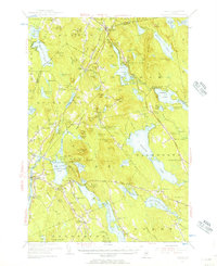 1955 Orland1956 Print · USGSCoastal Maine in the mid-fifties is captured here as a landscape of interconnected ponds and granite ridges. Genealogists and historians can trace family-named landmarks like Condon Hill, locate the U S Fish Hatchery, and find the Annear Copper Mine.4 unique versions available
 - 1956 Map of Mount Desert, 1960 Print
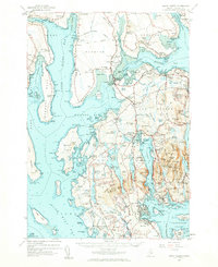 1956 Mount Desert1960 Print · USGSMount Desert Island and the surrounding Maine coast are shown here in the mid-fifties, before modern expansion altered the local landscape. Genealogists and historians can trace coastal heritage through landmarks like Somesville, Federated Ch, and family sites like Marlboro Cem.4 unique versions available
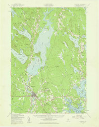
 - 1956 Map of Bangor, 1966 Print
 1956 Bangor1966 Print · USGSMid-century Maine comes alive in this survey of the rugged coast and river valleys during the 1950s. Genealogists and historians can trace the vital rail corridors of the Maine Central RR connecting timber towns like Old Town to the coast at Bar Harbor.3 unique versions available
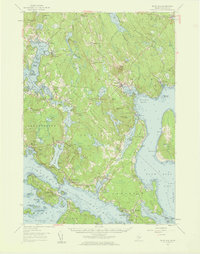
 - 1957 Map of Ellsworth, 1959 Print
 1957 Ellsworth1959 Print · USGSHancock County at the end of the fifties shows the critical transition from rail-dependent industry to the modern highway era. Researchers can trace historic family burial sites and rural schoolhouses, including Hillside Cem, Stetson Sch, and the junctions of the Maine Central Railroad.3 unique versions available
 - 1957 Map of Blue Hill, 1959 Print
 1957 Blue Hill1959 Print · USGSCoastal Hancock County in the late fifties reveals a maritime world of interconnected bays and small village centers. Genealogists and historians can trace family roots through sites like Number Three Chapel, Forest Home Cem, and the old docks at South Blue Hill.4 unique versions available
End of results
Showing maps 1-5 of 5
Top cities near Surry
- Ellsworth historical maps
- Bar Harbor historical maps
- Bucksport historical maps
- Orrington historical maps
- Blue Hill historical maps
- Hancock historical maps
See more
Top neighborhoods of Surry
- East Surry historical maps
- Richs Corner historical maps
- South Surry historical maps
- West Surry historical maps
Frequently asked questions
- What are the different types of historical maps available for Surry?
- What is the oldest map of Surry?
- Where can I purchase historical maps of Surry for my home or office?
- Where can I download high-res historical maps of Surry?
- Are there historical topographic maps available for Surry?
- Is there historical aerial imagery available for Surry?
- Where are historical maps of Surry sourced from?