1980s Maps of McCoy Crossing, Vassalboro
Explore 2 historic maps of McCoy Crossing from the 1980s. These maps offer a rare glimpse into what life looked like during the 1980s — showing old roads, neighborhoods, homes, and landmarks that have changed or disappeared over time.
Whether you're researching your family's past, planning a metal detecting trip, or studying how McCoy Crossing's landscape evolved across the 1980s, these high-resolution maps are a powerful tool for exploring the history of this region.
- Focus on a specific era: All maps on this page are from the 1980s, giving you a focused view of this time period.
- See what’s changed: Compare century-old streets, trails, and buildings to today's modern landscape using overlays and satellite layers.
- Research with precision: Use these maps for genealogy, historical research, land use analysis, or educational projects.
- View, download, or print: Maps are fully viewable online in high resolution, and can be downloaded or printed for your own records.
Start exploring McCoy Crossing's history through authentic maps from the 1980s. This is your window into the past.
McCoy Crossing, Vassalboro maps
(2)- 1983 Map of Vassalboro
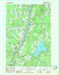 1983 Vassalboro1983 Print · USGSKennebec County comes into focus in the early 1980s as the river and rail network define life between Sidney and Vassalboro. Genealogists and historians can trace family roots through numerous burial grounds like Bowman Cem and landmarks such as Seaward Mills or the Oak Grove-Coburn Sch.2 unique versions available
 - 1984 Map of Augusta
 1984 Augusta1984 Print · USGSMid-coast and central Maine were undergoing steady change in the mid-eighties as traditional river and coastal industries met expanding recreation. You can trace the Maine Central RR through Augusta or explore the rugged shoreline from Rockland Harbor up to Mount Megunticook.
End of results
Showing maps 1-2 of 2
Frequently asked questions
- What are the different types of historical maps available for McCoy Crossing?
- What is the oldest map of McCoy Crossing?
- Where can I purchase historical maps of McCoy Crossing for my home or office?
- Where can I download high-res historical maps of McCoy Crossing?
- Are there historical topographic maps available for McCoy Crossing?
- Is there historical aerial imagery available for McCoy Crossing?
- Where are historical maps of McCoy Crossing sourced from?