Old Maps of Pea Ridge, Chester for Metal Detecting
Plan your next treasure hunt with 14 historic maps of Pea Ridge. Find old homesites, ghost towns, trails, and gathering spots that may be lost to time — perfect for identifying promising metal detecting locations.
- Locate forgotten sites: Uncover places like long-lost settlements, abandoned rail lines, or gathering spots.
- Plan better hunts: Use map overlays combined with LiDAR or satellite views to narrow in on historically rich areas.
- Made for detectorists: Thousands of hobbyists use these maps to discover relics, coins, and hidden history.
Use these historic maps to boost your research and find new opportunities beneath the surface of Pea Ridge.
Pea Ridge, Chester maps
(14)- 1942 Map of Lincoln
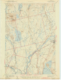 1942 Lincoln1942 Print · USGSPenobscot River life and the timber-driven rail economy are captured here during the early years of the war. Genealogists and historians can locate old landmarks like Merrifield Sch, the Ridge Cem, and the river island communities of the Penobscot Indian Reservation.3 unique versions available
 - 1954 Map of Millinocket, 1968 Print
 1954 Millinocket1968 Print · USGSMaine's North Woods and the Penobscot Valley are captured here during the mid-century era of logging and rail dominance. You can trace the path of the Bangor and Aroostook Railroad through timber towns like Millinocket, Mattawamkeag, and Silver Ridge.3 unique versions available
 - 1957 Map of Lincoln, 1959 Print
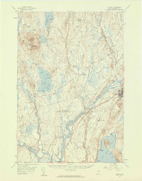 1957 Lincoln1959 Print · USGSPenobscot River towns and the Maine woods are captured here in the late fifties, showing the vital rail-and-river corridor. Genealogists and historians can trace rail lines like the Maine Central, locate the Fairfield Sch, and find the remote Mattamiscontis Club Camp.3 unique versions available
 - 1958 Map of Millinocket
 1958 Millinocket1958 Print · USGSMaine's North Woods and the Penobscot river valley are captured here in the mid-1950s, showing a landscape of timber, rail, and wild waters. Researchers can trace the legacy of the Canadian Pacific railroad and find historic settlements like Millinocket, Sherman Station, and Mattawamkeag.
 - 1960 Map of Millinocket
 1960 Millinocket1960 Print · USGSThe Maine North Woods and Penobscot River valley are captured at mid-century during the height of the paper milling era. Researchers can trace the Appalachian Trail near Mount Katardin or locate family roots in towns like Dover-Foxcroft and Milo.3 unique versions available
 - 1975 Map of Lincoln NE, 1980 Print
 1975 Lincoln NE1980 Print · USGSPenobscot County timberlands and river corridors are captured in this mid-seventies aerial survey of the Maine woods. Researchers can trace forest management patterns and waterways including the Penobscot River, Pea Ridge, and the Medunkeunk River.
 - 1985 Map of Lincoln, 1994 Print
 1985 Lincoln1994 Print · USGSPenobscot County in the mid-eighties remains a landscape of river-based commerce and sprawling timberlands connected by rail. You can trace the historic paths of the Maine Central RR and Canadian Pacific RR or locate rural sites like Enfield Station and the Winn Cem.
 - 1986 Map of Lincoln
 1986 Lincoln1986 Print · USGSMid-century Maine settlement and industry converge along the Penobscot and Piscataquis rivers during the 1980s. Researchers can trace the rail networks of the Maine Central and Bangor and Aroostook through towns like Howland and Milo.
 - 1988 Map of Nine Meadow Ridge
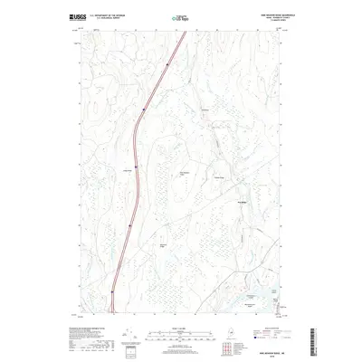
 1988 Nine Meadow Ridge1988 Print · USGSThe riverfront and timberlands of Penobscot County are documented here in the late eighties, showing the region's unique glacial topography and river settlements. Researchers can trace the Penobscot River through Lincoln Center or find remote landmarks like The Horseback and the Woodard (Site).
 - 2011 Map of Nine Meadow Ridge, 2011 Print
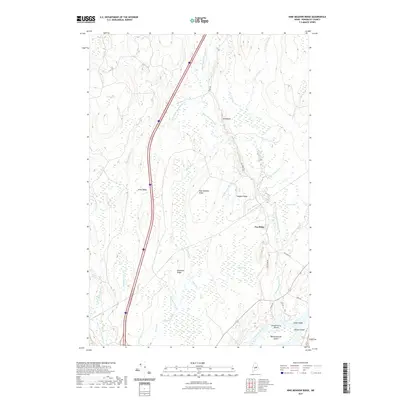
 2011 Nine Meadow Ridge2011 Print · USGSCovers Pea Ridge, including Lincoln, Chester, and other nearby areas
 - 2014 Map of Nine Meadow Ridge, 2014 Print
 2014 Nine Meadow Ridge2014 Print · USGSCovers Pea Ridge, including Lincoln, Chester, and other nearby areas
 - 2018 Map of Nine Meadow Ridge, 2018 Print
 2018 Nine Meadow Ridge2018 Print · USGSCovers Pea Ridge, including Lincoln, Chester, and other nearby areas
 - 2021 Map of Nine Meadow Ridge, 2021 Print
 2021 Nine Meadow Ridge2021 Print · USGSCovers Pea Ridge, including Lincoln, Chester, and other nearby areas
 - 2024 Map of Nine Meadow Ridge, 2024 Print
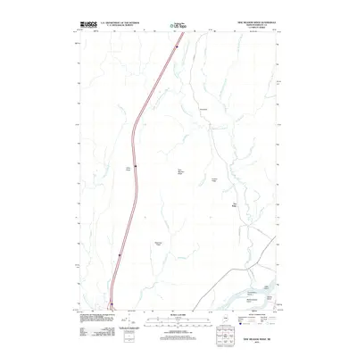
 2024 Nine Meadow Ridge2024 Print · USGSThe Penobscot River and its wooded islands define this area of Maine in the 2020s. Researchers can trace land patterns near Lincoln and Chester or locate landmarks like Horseback and Mattanawcook Island.
End of results
Showing maps 1-14 of 14
Frequently asked questions
- What are the different types of historical maps available for Pea Ridge?
- What is the oldest map of Pea Ridge?
- Where can I purchase historical maps of Pea Ridge for my home or office?
- Where can I download high-res historical maps of Pea Ridge?
- Are there historical topographic maps available for Pea Ridge?
- Is there historical aerial imagery available for Pea Ridge?
- Where are historical maps of Pea Ridge sourced from?