Old Maps of Greenfield Township, Maine for Genealogy
Trace your family roots with 33 historic maps of Greenfield Township. These high-res maps reveal old neighborhoods, homesites, landmarks, and streets — helping you uncover where your ancestors lived and how the area evolved over time.
- Explore historic neighborhoods: Identify where your relatives may have lived in the 1800s or 1900s.
- Compare maps over time: Trace the changes in streets, buildings, and landmarks for multi-generational research.
- Perfect for genealogy & ancestry research: Used by family historians and researchers to map out lineage and migration.
These maps are an incredible resource for exploring your personal connection to Greenfield Township's past.
Greenfield Township, ME maps
(33)- 1902 Map of Orono
 1902 Orono1902 Print · USGSPenobscot River life at the turn of the century centered on a busy corridor of rail, river, and industry. Researchers can trace the early footprint of the University, the rail lines of the Bangor and Aroostook RR, and settlements like Basin Mills and Indian Island.6 unique versions available
 - 1917 Map of Passadumkeag
 1917 Passadumkeag1917 Print · USGSIn the early twentieth century, the Penobscot River valley was a busy corridor of rail transit and small-town commerce. Genealogists can trace family footprints through numerous local schools like Hemlock School and the post office at West Enfield P.O.7 unique versions available
 - 1929 Map of Great Pond
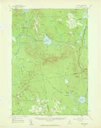
 1929 Great Pond1929 Print · USGSThe rural interior of Hancock County is captured here in the late twenties during a period of remote timber camps and small mountain schools. Researchers can locate long-standing landmarks such as Archer's Corners, Rebel Hill Sch, and the isolated Rackliff Camp.
 - 1931 Map of Saponac
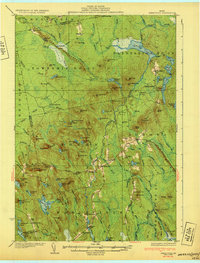
 1931 Saponac1931 Print · USGSThe Maine wilderness of the early thirties is captured here before modern development, spanning the border of Penobscot and Hancock counties. Researchers can trace rural life through the locations of the Greenfield Cemetery, the Morrison Mill, and several district schools like School No 1.
 - 1932 Map of Great Pond
 1932 Great Pond1932 Print · USGSHancock and Penobscot Counties are captured here in the early thirties, showcasing the timberlands and small settlements along the Airline Road. Local historians can trace family roots through sites like the Goodwin School, Archers Corners, and North Mariaville.4 unique versions available
 - 1934 Map of Saponac
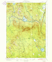 1934 Saponac1934 Print · USGSPenobscot County was a landscape of small mill towns and mountain ridges in the 1930s. Researchers can locate early district schools like Longfellow Sch, industrial sites such as Morrison Mill, and family landmarks including Crocker Turn.3 unique versions available
 - 1944 Map of Orono, 1954 Print
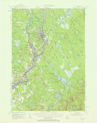
 1944 Orono1954 Print · USGSThe Penobscot River corridor is captured here in the mid-1940s, showing the early footprint of the University of Maine and the industrial activity of Old Town. Genealogists and historians can trace family locations through French Settlement, Woodlawn Cem, and the Old Gold Mine.2 unique versions available
 - 1946 Map of Orono
 1946 Orono1946 Print · USGSPenobscot County industry and academia meet along the river in the mid-forties. Genealogists and historians can trace the development of Marsh Island, locate the University of Maine campus, and find local landmarks like the Old Gold Mine Trail.2 unique versions available
 - 1948 Map of Bangor
 1948 Bangor1948 Print · USGSThe Maine coast and its industrial river valleys are captured here shortly after the war, showing the vital shipping and rail hubs of the late 1940s. Genealogists and historians can trace the tracks of the Maine Central RR connecting Bangor, Augusta, and Old Town.
 - 1954 Map of Millinocket, 1968 Print
 1954 Millinocket1968 Print · USGSMaine's North Woods and the Penobscot Valley are captured here during the mid-century era of logging and rail dominance. You can trace the path of the Bangor and Aroostook Railroad through timber towns like Millinocket, Mattawamkeag, and Silver Ridge.3 unique versions available
 - 1955 Map of Orono, 1957 Print
 1955 Orono1957 Print · USGSThe Penobscot river valley thrived as a center of education and industry in the mid-fifties, anchored by Indian Island and the university. Genealogists and historians can trace family-named sites from French Settlement to Clewleyville Corners and the Old Gold Mine.4 unique versions available
 - 1956 Map of Bangor, 1966 Print
 1956 Bangor1966 Print · USGSMid-century Maine comes alive in this survey of the rugged coast and river valleys during the 1950s. Genealogists and historians can trace the vital rail corridors of the Maine Central RR connecting timber towns like Old Town to the coast at Bar Harbor.3 unique versions available
 - 1957 Map of Great Pond, 1959 Print
 1957 Great Pond1959 Print · USGSHancock County's interior townships are shown here in the late fifties as military recreation and training sites integrated with traditional rural settlements. Researchers can locate the Hadley Cem and several community schools like Monticello Sch and Caruso Sch.4 unique versions available
 - 1957 Map of Saponac, 1959 Print
 1957 Saponac1959 Print · USGSPenobscot and Hancock counties are shown here in the late fifties, during a period of rural stability in the Maine north woods. Researchers can locate family landmarks like Mt Repose Cem, the Thirty-Nine Tannery, and the Corner Sch in Lowell.4 unique versions available
 - 1958 Map of Millinocket
 1958 Millinocket1958 Print · USGSMaine's North Woods and the Penobscot river valley are captured here in the mid-1950s, showing a landscape of timber, rail, and wild waters. Researchers can trace the legacy of the Canadian Pacific railroad and find historic settlements like Millinocket, Sherman Station, and Mattawamkeag.
 - 1960 Map of Bangor
 1960 Bangor1960 Print · USGSCentral Maine in the sixties reveals a landscape of river-powered industry and sprawling coastal island chains. Researchers can trace the rail corridors of the Maine Central or locate mid-century aviation landmarks like Dow Air Force Base.
 - 1960 Map of Millinocket
 1960 Millinocket1960 Print · USGSThe Maine North Woods and Penobscot River valley are captured at mid-century during the height of the paper milling era. Researchers can trace the Appalachian Trail near Mount Katardin or locate family roots in towns like Dover-Foxcroft and Milo.3 unique versions available
 - 1960 Map of Passadumkeag, 1964 Print
 1960 Passadumkeag1964 Print · USGSPenobscot River life in the early sixties centers on riverside towns and rail hubs like Passadumkeag and Olamon. Genealogists can trace family names through rural landmarks like Cedarvale Cem, Edgecomb Sch, and the State Nursery.2 unique versions available
 - 1961 Map of Bangor
 1961 Bangor1961 Print · USGSMid-century Maine comes alive through its busy river ports and rocky archipelagoes during a period of steady maritime and rail commerce. Researchers can trace the path of the Maine Central railroad and locate coastal landmarks from Acadia National Park to Vinalhaven Island.
 - 1975 Map of Saponac SW, 1980 Print
 1975 Saponac SW1980 Print · USGSThe rural Maine woods around Greenfield are captured in high detail during the mid-seventies. Local historians and land-use researchers can trace the specific boundaries of clearings, forest tracks, and early structures within the Greenfield settlement area.
 - 1975 Map of Olamon, 1981 Print
 1975 Olamon1981 Print · USGSCentral Maine woodlands and rural settlements are captured in this mid-seventies aerial survey. Researchers can trace the winding course of Olamon Stream and locate small communities like Cardville and Olamon.
 - 1985 Map of Bangor
 1985 Bangor1985 Print · USGSMid-Maine during the mid-eighties centers on the industrial pulse of the Penobscot River and its critical rail connections. Genealogists and historians can trace the development of river towns from Old Town to Ellsworth and locate regional landmarks like Fort Knox State Park.
 - 1985 Map of Lincoln, 1994 Print
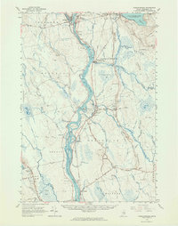
 1985 Lincoln1994 Print · USGSPenobscot County in the mid-eighties remains a landscape of river-based commerce and sprawling timberlands connected by rail. You can trace the historic paths of the Maine Central RR and Canadian Pacific RR or locate rural sites like Enfield Station and the Winn Cem.
 - 1986 Map of Lincoln
 1986 Lincoln1986 Print · USGSMid-century Maine settlement and industry converge along the Penobscot and Piscataquis rivers during the 1980s. Researchers can trace the rail networks of the Maine Central and Bangor and Aroostook through towns like Howland and Milo.
 - 1988 Map of Greenfield
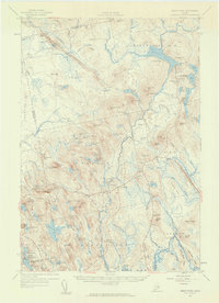
 1988 Greenfield1988 Print · USGSPenobscot and Hancock counties in the 1980s remain a landscape of dense woods and winding waterways. Researchers can trace local landmarks like Crocker Turn, locate the high ground at Cemetery Hill, and follow the remote course of Olamon Stream.
Showing maps 1-25 of 33
Top cities near Greenfield Township
- Orono historical maps
- Old Town historical maps
- Holden historical maps
- Milford historical maps
- Eddington historical maps
- Bradley historical maps
See more
Top neighborhoods of Greenfield Township
Frequently asked questions
- What are the different types of historical maps available for Greenfield Township?
- What is the oldest map of Greenfield Township?
- Where can I purchase historical maps of Greenfield Township for my home or office?
- Where can I download high-res historical maps of Greenfield Township?
- Are there historical topographic maps available for Greenfield Township?
- Is there historical aerial imagery available for Greenfield Township?
- Where are historical maps of Greenfield Township sourced from?