Old Maps of Monson, Maine
Explore 39 old maps of Monson, spanning from 1933 to today. These high-resolution historic maps reveal how streets, neighborhoods, landmarks, and natural features evolved over time — perfect for genealogy, metal detecting, research, and local history exploration.
What you can do with these maps:
- See how Monson changed over time: Compare historical maps to modern-day views to trace roads, homesites, rail lines & more.
- View detailed metadata: Each map includes creators, publishers, year, scale, and archive source.
- Overlay maps with satellite & LiDAR: Visualize the past alongside modern tools to explore terrain & human change.
- Trusted historical sources: Maps sourced from the USGS, Library of Congress, and other archives.
- Access maps your way: View online, download high-res files, or order prints for personal or research use.
Start exploring old maps of Monson to uncover forgotten places, hidden landmarks, and the deep history beneath your feet.
Monson, ME maps
(39)- 1933 Map of Guilford, 1958 Print
 1933 Guilford1958 Print · USGSPiscataquis County townships thrive along the river and rail lines of central Maine in the early thirties. Local historians can trace the foundations of Guilford, locate rural landmarks like Spooners Mill, and find family heritage at Storer Cem or Abbot Village Sta.5 unique versions available
 - 1937 Map of Guilford
 1937 Guilford1937 Print · USGSPiscataquis County industry and rural life are captured here in the mid-1930s as the river-and-rail economy thrived. Genealogists can trace family roots through numerous local schoolhouses and landmarks like Spooners Mill, Lows Bridge, and the Wassookeag Cem.2 unique versions available
 - 1948 Map of Kingsbury, 1953 Print
 1948 Kingsbury1953 Print · USGSCentral Maine's high country is captured here just after the war, showing the rural intersections of Piscataquis and Somerset Counties. Genealogists and historians can trace the family-named crossroads of Mayfield Corner, Hutchins Corner, and Moody Corner, alongside the Campbell Sch.3 unique versions available
 - 1950 Map of Kingsbury
 1950 Kingsbury1950 Print · USGSThe Maine interior at the dawn of the fifties is a patchwork of small crossroads and remote ponds. Genealogists and historians can trace family locations near Mayfield Corner, Brighton, and the Foss Hill Cem, or explore the rural school districts like Campbell Sch.2 unique versions available
 - 1950 Map of Sebec Lake, 1952 Print
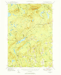
 1950 Sebec Lake1952 Print · USGSMid-century Piscataquis County reveals a landscape of slate quarries, remote rail outposts, and wilderness trails just after the war. You can trace the mining history near Monson at Hillside Quarry or follow the Canadian Pacific line to the settlement at Onawa.7 unique versions available
 - 1951 Map of Greenville, 1952 Print
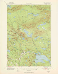
 1951 Greenville1952 Print · USGSThe Moosehead Lake region flourished as a rail and timber hub in the early fifties, where the northern woods met the water. Trace the path of the Appalachian Trail or locate the junction of the Canadian Pacific Railroad and Bangor and Aroostook Railroad near Greenville.6 unique versions available
 - 1954 Map of Millinocket, 1968 Print
 1954 Millinocket1968 Print · USGSMaine's North Woods and the Penobscot Valley are captured here during the mid-century era of logging and rail dominance. You can trace the path of the Bangor and Aroostook Railroad through timber towns like Millinocket, Mattawamkeag, and Silver Ridge.3 unique versions available
 - 1958 Map of Millinocket
 1958 Millinocket1958 Print · USGSMaine's North Woods and the Penobscot river valley are captured here in the mid-1950s, showing a landscape of timber, rail, and wild waters. Researchers can trace the legacy of the Canadian Pacific railroad and find historic settlements like Millinocket, Sherman Station, and Mattawamkeag.
 - 1960 Map of Millinocket
 1960 Millinocket1960 Print · USGSThe Maine North Woods and Penobscot River valley are captured at mid-century during the height of the paper milling era. Researchers can trace the Appalachian Trail near Mount Katardin or locate family roots in towns like Dover-Foxcroft and Milo.3 unique versions available
 - 1975 Map of Kingsbury NE, 1980 Print
 1975 Kingsbury NE1980 Print · USGSThe woods and waters of Piscataquis County appear in stark detail in the mid-1970s before modern development altered these forest tracts. Researchers can trace the winding Piscataquis River and locate remote landmarks like Thorn Pond and Foss Pond.
 - 1975 Map of Guilford NW, 1980 Print
 1975 Guilford NW1980 Print · USGSPiscataquis County settlements like Guilford and Abbot Village are shown in detail during the mid-seventies. This orthophoto allows you to trace the landscape from the banks of the Piscataquis River to the shores of Harlow Pond.
 - 1977 Map of Monson East, 1981 Print
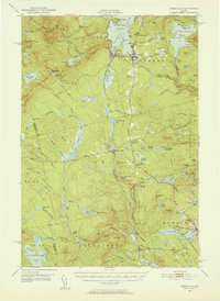
 1977 Monson East1981 Print · USGSMonson and the Piscataquis County woods are shown through late-seventies aerial imagery, revealing the exact footprint of Maine's inland settlements and timberlands. Researchers can trace land use around Monson and Willimantic or locate Finn Hall.
 - 1977 Map of Monson West, 1981 Print
 1977 Monson West1981 Print · USGSPiscataquis County timberlands and lakeside settlements are documented here in the late seventies. Researchers can trace the layout of small communities like Shirley Mills and Monson or locate homesteads near Lake Hebron.
 - 1984 Map of Guilford
 1984 Guilford1984 Print · USGSMid-century Maine life centers on the river and rail corridors of the Piscataquis valley in the early 1980s. Researchers can trace family roots through Elmwood Cem or explore the layout of old hubs like Abbot Village and Monson Junction.2 unique versions available
 - 1986 Map of Dover-Foxcroft
 1986 Dover-Foxcroft1986 Print · USGSPiscataquis County at the edge of the great Maine woods is documented here in the mid-1980s, centered on the river-and-rail hubs of the interior. Trace the industrial footprints of Dover South Mills, the rail yards at Brownville Junction, or the historic Katahdin Iron Works.
 - 1988 Map of Monson East
 1988 Monson East1988 Print · USGSThe Piscataquis County highlands in the late 1980s show a region defined by its slate mining history and the famous Appalachian Trail. Genealogists and historians can locate specific industrial sites like Rineo Quarry and community landmarks such as Finn Hall and Goodell Corner.
 - 1989 Map of Monson West
 1989 Monson West1989 Print · USGSIn the late eighties, this part of Piscataquis County retained its character as a hub for timber history and outdoor recreation. Researchers can trace the routes of the Appalachian National Scenic Trail or locate family sites in Monson, Blanchard, and Shirley Mills.
 - 1989 Map of Whetstone Pond
 1989 Whetstone Pond1989 Print · USGSPiscataquis County at the close of the 1980s is captured here as a landscape of isolated plantations and deep woods. Researchers can trace the quiet crossroads of Happy Corner and Cole Corner or locate seasonal sites around Whetstone Pond and Piper Pond.
 - 1994 Map of Dover-Foxcroft
 1994 Dover-Foxcroft1994 Print · USGSCentral Maine in the mid-nineties shows a landscape of timber-driven towns and deep glacial lakes. Trace the paths of the Canadian Pacific RR or locate the Moscow Air Force Station Transmit Site and Sebec Lake.
 - 2011 Map of Whetstone Pond, 2011 Print
 2011 Whetstone Pond2011 Print · USGSCovers Monson, including Parkman, Abbot, and other nearby areas
 - 2011 Map of Monson West, 2011 Print
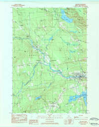
 2011 Monson West2011 Print · USGSCovers Monson, including Shirley, Blanchard Township, and other nearby areas
 - 2011 Map of Monson East, 2011 Print
 2011 Monson East2011 Print · USGSCovers Monson, including Guilford, Willimantic, and other nearby areas
 - 2011 Map of Guilford, 2011 Print
 2011 Guilford2011 Print · USGSCovers Monson, including Sangerville, Guilford, and other nearby areas
 - 2014 Map of Monson East, 2014 Print
 2014 Monson East2014 Print · USGSCovers Monson, including Guilford, Willimantic, and other nearby areas
 - 2014 Map of Guilford, 2014 Print
 2014 Guilford2014 Print · USGSCovers Monson, including Sangerville, Guilford, and other nearby areas
Showing maps 1-25 of 39
Top cities near Monson
- Dover-Foxcroft historical maps
- Dexter historical maps
- Greenville historical maps
- Sangerville historical maps
- Guilford historical maps
- Parkman historical maps
See more
Top neighborhoods of Monson
Frequently asked questions
- What are the different types of historical maps available for Monson?
- What is the oldest map of Monson?
- Where can I purchase historical maps of Monson for my home or office?
- Where can I download high-res historical maps of Monson?
- Are there historical topographic maps available for Monson?
- Is there historical aerial imagery available for Monson?
- Where are historical maps of Monson sourced from?