Old Maps of Piscataquis County, Maine
Explore 799 old maps of Piscataquis County, spanning from 1905 to today. These high-resolution historic maps reveal how streets, neighborhoods, landmarks, and natural features evolved over time — perfect for genealogy, metal detecting, research, and local history exploration.
What you can do with these maps:
- See how Piscataquis County changed over time: Compare historical maps to modern-day views to trace roads, homesites, rail lines & more.
- View detailed metadata: Each map includes creators, publishers, year, scale, and archive source.
- Overlay maps with satellite & LiDAR: Visualize the past alongside modern tools to explore terrain & human change.
- Trusted historical sources: Maps sourced from the USGS, Library of Congress, and other archives.
- Access maps your way: View online, download high-res files, or order prints for personal or research use.
Start exploring old maps of Piscataquis County to uncover forgotten places, hidden landmarks, and the deep history beneath your feet.
Piscataquis County, ME maps
(799)- 1905 Map of The Forks, 1954 Print
 1905 The Forks1954 Print · USGSThe Forks region of Somerset County was a wild landscape of timber tracts and river junctions at the turn of the century. You can trace the early logging routes along the Tote Road and locate remote landmarks like Squirt Gun Dam and the 10000 Acre Tract.
 - 1907 Map of The Forks
 1907 The Forks1907 Print · USGSSomerset County's logging heartland is captured at a pivotal moment as the Somerset R. R. pushed north toward the boundary. Local historians can trace early timber camps and river infrastructure like Squirtgun Dam and the Tote Road near The Forks.4 unique versions available
 - 1920 Map of Moosehead Lake, 1955 Print
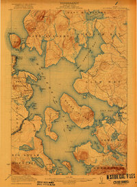
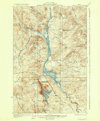
 1920 Moosehead Lake1955 Print · USGSMoosehead Lake in the early twentieth century was a hub of rail travel and island settlements accessible primarily by water. You can trace the historic Steamboat Route between Kineo Station, the Masterman School, and the remote outpost of Capens.
 - 1921 Map of Brassua Lake
 1921 Brassua Lake1921 Print · USGSThe North Maine Woods come alive in the 1920s at the intersection of the Canadian Pacific and Maine Central railroads. Genealogists and historians can trace logging-era life at Somerset Junction, Blaine School, and numerous seasonal sites like Depot Camp.3 unique versions available
 - 1922 Map of Moosehead Lake
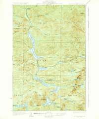
 1922 Moosehead Lake1922 Print · USGSPiscataquis County’s wilderness is caught in a moment of transition during the early twenties as railroads and steamers opened the north woods. Researchers can trace the rails to Kineo Station or locate remote outposts like Masterman School and Capens.7 unique versions available
 - 1923 Map of Brassua Lake
 1923 Brassua Lake1923 Print · USGSRailroads and river routes intersect in the Maine north woods at the start of the 1920s. Genealogists and historians can trace the junction of the Canadian Pacific at Somerset Junction Tarratine PO and locate remote outposts like Blaine School and Cornish Farm.4 unique versions available
 - 1927 Map of Katahdin
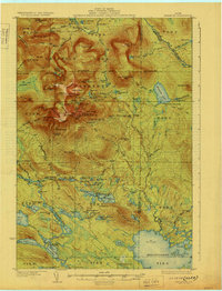
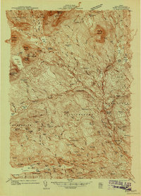
 1927 Katahdin1927 Print · USGSNorthern Maine during the late 1920s offered a landscape of wilderness outposts and towering peaks within the Katahdin Park Game Preserve. Trace old logging ways and early recreation spots like Traceys Camp, Pitmans Garage, and Monument Peak.
 - 1930 Map of Moosehead Lake
 1930 Moosehead Lake1930 Print · USGSMoosehead Lake in the early twentieth century was a landscape of remote rail junctions and lakeside settlements. Trace the old routes of the Maine Central Railroad to Rockwood or locate the Masterman School near the shores of North Bay.
 - 1930 Map of Katahdin
 1930 Katahdin1930 Print · USGSBackcountry Maine in the late 1920s offered a rugged landscape of newly surveyed trails and remote outposts. You can trace the early paths to Mount Katahdin and locate historic sites like Sewell Camp, Katahdin Lake Camp, and New City.6 unique versions available
 - 1931 Map of Mooseleuk Lake
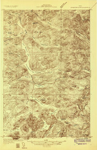
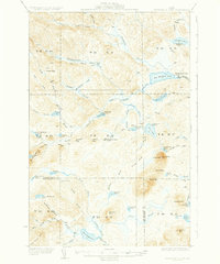
 1931 Mooseleuk Lake1931 Print · USGSThe Aroostook and Piscataquis county borderlands are shown here in the early thirties as a vast expanse of timber and water. Trace the locations of remote outposts like Big Machias Lake Camps and the Great Northern Dam.2 unique versions available
 - 1932 Map of Umsaskis Lake
 1932 Umsaskis Lake1932 Print · USGSThe northern Maine wilderness of the early 1930s is documented here as a landscape of timber camps and remote warden stations. Researchers can trace the era's logging infrastructure through sites like Churchill Depot, Harvey Farm, and the American Realty Depot Camp.4 unique versions available
 - 1932 Map of Dover-Foxcroft
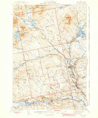
 1932 Dover-Foxcroft1932 Print · USGSPiscataquis and Penobscot counties are shown here in the early 1930s, a landscape defined by the Piscataquis River and rail-fed mill towns. Genealogists can trace family names through dozens of rural landmarks like Hurd Corner, Gould Cemetery, and the Higgins Classical Institute.4 unique versions available
 - 1932 Map of Musquacook Lakes
 1932 Musquacook Lakes1932 Print · USGSThe North Maine Woods are captured in the early 1930s as a remote network of timber lands and glacial lakes. Trace the primitive logging routes of the California Road and Tote Road past camps like Howes Camp and the five Musquacook Lakes.4 unique versions available
 - 1933 Map of Boyd Lake
 1933 Boyd Lake1933 Print · USGSPenobscot County communities and the Piscataquis River valley are captured here in the early thirties as the railroad remained the lifeblood of rural Maine. Local historians can trace numerous family-named landmarks and district schoolhouses like Knowles Sch, Ridge Sch, and the Huntington Mill works.
 - 1933 Map of Guilford, 1958 Print
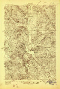
 1933 Guilford1958 Print · USGSPiscataquis County townships thrive along the river and rail lines of central Maine in the early thirties. Local historians can trace the foundations of Guilford, locate rural landmarks like Spooners Mill, and find family heritage at Storer Cem or Abbot Village Sta.5 unique versions available
 - 1935 Map of Umsaskis Lake
 1935 Umsaskis Lake1935 Print · USGSThe Allagash wilderness in the early 1930s is documented here through its logging camps and river-driving infrastructure. Genealogists and researchers can trace remote outposts like Harvey Farm, the American Realty Depot Camp, and the Paquetta Sch.3 unique versions available
 - 1935 Map of Musquacook Lakes
 1935 Musquacook Lakes1935 Print · USGSThe remote Aroostook County timberlands are revealed in this mid-thirties survey, showing a landscape defined by the great Musquacook chain. Researchers can trace historic logging access via the American Realty Tote Road or locate the fire tower atop Clear Lake Mtn.3 unique versions available
 - 1935 Map of Dover-Foxcroft
 1935 Dover-Foxcroft1935 Print · USGSThe Piscataquis River valley of central Maine is shown here in the 1930s, centered on the mill town of Dover-Foxcroft. Genealogists can trace family names at Rollins Mill, Foss Cem, and dozens of rural schoolhouses like Morrison Sch.2 unique versions available
 - 1935 Map of Mooseleuk Lake
 1935 Mooseleuk Lake1935 Print · USGSRemote timberlands across the Aroostook and Piscataquis county lines are shown here during the mid-1930s. Researchers can locate specialized logging outposts like Storms Camp, Twentyfivemile Camp, and the Fire Tower monitoring the forests from Round Mtn.3 unique versions available
 - 1937 Map of Guilford
 1937 Guilford1937 Print · USGSPiscataquis County industry and rural life are captured here in the mid-1930s as the river-and-rail economy thrived. Genealogists can trace family roots through numerous local schoolhouses and landmarks like Spooners Mill, Lows Bridge, and the Wassookeag Cem.2 unique versions available
 - 1940 Map of Sebec
 1940 Sebec1940 Print · USGSPiscataquis County in the early 1940s is captured here at a crossroads of the iron and timber industries. Researchers can locate the Katahdin Iron Works, trace the rail yards at Brownville Junction, and find rural schools like Williamsburg Sch.4 unique versions available
 - 1943 Map of Sebec
 1943 Sebec1943 Print · USGSPiscataquis County in the early 1940s is a landscape of iron works, timber rails, and remote schools. Genealogists and historians can trace the paths of the CANADIAN PACIFIC railroad and locate sites like the Williamsburg Sch, Katahdin Iron Works, and Barnard Corner.4 unique versions available
 - 1944 Map of Brassua Lake
 1944 Brassua Lake1944 Print · USGSCentral Maine was a landscape of remote sporting camps and logging rail lines in the mid-1940s. Genealogists and historians can trace old homesteads and landmarks like Somerset Junction, Blaine Sch, and Cornish Farm.
 - 1944 Map of Moosehead Lake
 1944 Moosehead Lake1944 Print · USGSThe heart of Maine's lake country is captured here during the mid-forties, showing the vital rail and water routes of the North Woods. Genealogists and historians can trace the Canadian Pacific line, the remote Masterman Sch, and early settlements like Rockwood.
 - 1947 Map of Schoodic, 1956 Print
 1947 Schoodic1956 Print · USGSPiscataquis County in the late 1940s is shown here as a landscape of timber, rail, and isolated lake settlements. Genealogists and historians can trace old homesteads and landmarks like Evergreen Cem, the Maxfield Sch, and the rail stops at Packards or Lake View.3 unique versions available
Showing maps 1-25 of 799
Top cities of Piscataquis County
- Dover-Foxcroft historical maps
- Milo historical maps
- Greenville historical maps
- Sangerville historical maps
- Guilford historical maps
- Brownville historical maps
See more
Frequently asked questions
- What are the different types of historical maps available for Piscataquis County?
- What is the oldest map of Piscataquis County?
- Where can I purchase historical maps of Piscataquis County for my home or office?
- Where can I download high-res historical maps of Piscataquis County?
- Are there historical topographic maps available for Piscataquis County?
- Is there historical aerial imagery available for Piscataquis County?
- Where are historical maps of Piscataquis County sourced from?