1930s Maps of Piscataquis County, Maine
Explore 13 historic maps of Piscataquis County from the 1930s. These maps offer a rare glimpse into what life looked like during the 1930s — showing old roads, neighborhoods, homes, and landmarks that have changed or disappeared over time.
Whether you're researching your family's past, planning a metal detecting trip, or studying how Piscataquis County's landscape evolved across the 1930s, these high-resolution maps are a powerful tool for exploring the history of this region.
- Focus on a specific era: All maps on this page are from the 1930s, giving you a focused view of this time period.
- See what’s changed: Compare century-old streets, trails, and buildings to today's modern landscape using overlays and satellite layers.
- Research with precision: Use these maps for genealogy, historical research, land use analysis, or educational projects.
- View, download, or print: Maps are fully viewable online in high resolution, and can be downloaded or printed for your own records.
Start exploring Piscataquis County's history through authentic maps from the 1930s. This is your window into the past.
Piscataquis County, ME maps
(13)- 1930 Map of Moosehead Lake
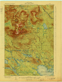
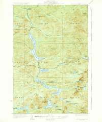
 1930 Moosehead Lake1930 Print · USGSMoosehead Lake in the early twentieth century was a landscape of remote rail junctions and lakeside settlements. Trace the old routes of the Maine Central Railroad to Rockwood or locate the Masterman School near the shores of North Bay.
 - 1930 Map of Katahdin
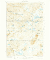
 1930 Katahdin1930 Print · USGSBackcountry Maine in the late 1920s offered a rugged landscape of newly surveyed trails and remote outposts. You can trace the early paths to Mount Katahdin and locate historic sites like Sewell Camp, Katahdin Lake Camp, and New City.6 unique versions available
 - 1931 Map of Mooseleuk Lake
 1931 Mooseleuk Lake1931 Print · USGSThe Aroostook and Piscataquis county borderlands are shown here in the early thirties as a vast expanse of timber and water. Trace the locations of remote outposts like Big Machias Lake Camps and the Great Northern Dam.2 unique versions available
 - 1932 Map of Umsaskis Lake
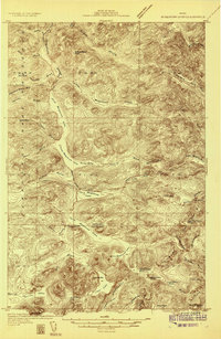
 1932 Umsaskis Lake1932 Print · USGSThe northern Maine wilderness of the early 1930s is documented here as a landscape of timber camps and remote warden stations. Researchers can trace the era's logging infrastructure through sites like Churchill Depot, Harvey Farm, and the American Realty Depot Camp.4 unique versions available
 - 1932 Map of Dover-Foxcroft
 1932 Dover-Foxcroft1932 Print · USGSPiscataquis and Penobscot counties are shown here in the early 1930s, a landscape defined by the Piscataquis River and rail-fed mill towns. Genealogists can trace family names through dozens of rural landmarks like Hurd Corner, Gould Cemetery, and the Higgins Classical Institute.4 unique versions available
 - 1932 Map of Musquacook Lakes
 1932 Musquacook Lakes1932 Print · USGSThe North Maine Woods are captured in the early 1930s as a remote network of timber lands and glacial lakes. Trace the primitive logging routes of the California Road and Tote Road past camps like Howes Camp and the five Musquacook Lakes.4 unique versions available
 - 1933 Map of Boyd Lake
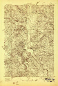
 1933 Boyd Lake1933 Print · USGSPenobscot County communities and the Piscataquis River valley are captured here in the early thirties as the railroad remained the lifeblood of rural Maine. Local historians can trace numerous family-named landmarks and district schoolhouses like Knowles Sch, Ridge Sch, and the Huntington Mill works.
 - 1933 Map of Guilford, 1958 Print
 1933 Guilford1958 Print · USGSPiscataquis County townships thrive along the river and rail lines of central Maine in the early thirties. Local historians can trace the foundations of Guilford, locate rural landmarks like Spooners Mill, and find family heritage at Storer Cem or Abbot Village Sta.5 unique versions available
 - 1935 Map of Umsaskis Lake
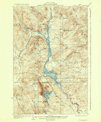 1935 Umsaskis Lake1935 Print · USGSThe Allagash wilderness in the early 1930s is documented here through its logging camps and river-driving infrastructure. Genealogists and researchers can trace remote outposts like Harvey Farm, the American Realty Depot Camp, and the Paquetta Sch.3 unique versions available
 - 1935 Map of Musquacook Lakes
 1935 Musquacook Lakes1935 Print · USGSThe remote Aroostook County timberlands are revealed in this mid-thirties survey, showing a landscape defined by the great Musquacook chain. Researchers can trace historic logging access via the American Realty Tote Road or locate the fire tower atop Clear Lake Mtn.3 unique versions available
 - 1935 Map of Dover-Foxcroft
 1935 Dover-Foxcroft1935 Print · USGSThe Piscataquis River valley of central Maine is shown here in the 1930s, centered on the mill town of Dover-Foxcroft. Genealogists can trace family names at Rollins Mill, Foss Cem, and dozens of rural schoolhouses like Morrison Sch.2 unique versions available
 - 1935 Map of Mooseleuk Lake
 1935 Mooseleuk Lake1935 Print · USGSRemote timberlands across the Aroostook and Piscataquis county lines are shown here during the mid-1930s. Researchers can locate specialized logging outposts like Storms Camp, Twentyfivemile Camp, and the Fire Tower monitoring the forests from Round Mtn.3 unique versions available
 - 1937 Map of Guilford
 1937 Guilford1937 Print · USGSPiscataquis County industry and rural life are captured here in the mid-1930s as the river-and-rail economy thrived. Genealogists can trace family roots through numerous local schoolhouses and landmarks like Spooners Mill, Lows Bridge, and the Wassookeag Cem.2 unique versions available
End of results
Showing maps 1-13 of 13
Top cities of Piscataquis County
- Dover-Foxcroft historical maps
- Milo historical maps
- Greenville historical maps
- Sangerville historical maps
- Guilford historical maps
- Brownville historical maps
See more
Frequently asked questions
- What are the different types of historical maps available for Piscataquis County?
- What is the oldest map of Piscataquis County?
- Where can I purchase historical maps of Piscataquis County for my home or office?
- Where can I download high-res historical maps of Piscataquis County?
- Are there historical topographic maps available for Piscataquis County?
- Is there historical aerial imagery available for Piscataquis County?
- Where are historical maps of Piscataquis County sourced from?