Old Maps of Medford, Maine
Explore 38 old maps of Medford, spanning from 1933 to today. These high-resolution historic maps reveal how streets, neighborhoods, landmarks, and natural features evolved over time — perfect for genealogy, metal detecting, research, and local history exploration.
What you can do with these maps:
- See how Medford changed over time: Compare historical maps to modern-day views to trace roads, homesites, rail lines & more.
- View detailed metadata: Each map includes creators, publishers, year, scale, and archive source.
- Overlay maps with satellite & LiDAR: Visualize the past alongside modern tools to explore terrain & human change.
- Trusted historical sources: Maps sourced from the USGS, Library of Congress, and other archives.
- Access maps your way: View online, download high-res files, or order prints for personal or research use.
Start exploring old maps of Medford to uncover forgotten places, hidden landmarks, and the deep history beneath your feet.
Medford, ME maps
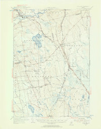
(38)- 1933 Map of Boyd Lake
 1933 Boyd Lake1933 Print · USGSPenobscot County communities and the Piscataquis River valley are captured here in the early thirties as the railroad remained the lifeblood of rural Maine. Local historians can trace numerous family-named landmarks and district schoolhouses like Knowles Sch, Ridge Sch, and the Huntington Mill works.
 - 1947 Map of Schoodic, 1956 Print
 1947 Schoodic1956 Print · USGSPiscataquis County in the late 1940s is shown here as a landscape of timber, rail, and isolated lake settlements. Genealogists and historians can trace old homesteads and landmarks like Evergreen Cem, the Maxfield Sch, and the rail stops at Packards or Lake View.3 unique versions available
 - 1949 Map of Schoodic
 1949 Schoodic1949 Print · USGSThe rail-and-river network of central Maine is captured here just after the war, showing the junction of two major rail lines. Genealogists and historians can trace old community sites like Lake View, Knights Landing, and the Maxfield Sch.2 unique versions available
 - 1951 Map of Boyd Lake
 1951 Boyd Lake1951 Print · USGSPenobscot and Piscataquis Counties are captured here in the early 1950s, showing a landscape of timber-rail economies and scattered rural schoolhouses. Genealogists can trace family footprints at Bradford Center, the Hoxie Sch, or along the Bangor and Aroostook rail line.
 - 1954 Map of Millinocket, 1968 Print
 1954 Millinocket1968 Print · USGSMaine's North Woods and the Penobscot Valley are captured here during the mid-century era of logging and rail dominance. You can trace the path of the Bangor and Aroostook Railroad through timber towns like Millinocket, Mattawamkeag, and Silver Ridge.3 unique versions available
 - 1955 Map of Boyd Lake, 1956 Print
 1955 Boyd Lake1956 Print · USGSPenobscot and Piscataquis counties are captured here in the mid-fifties as the rail-and-river economy supported towns like Milo and Derby. Genealogists can locate family landmarks such as the Orneville Sch, Williams Cem, and the Bradford High Sch.4 unique versions available
 - 1958 Map of Millinocket
 1958 Millinocket1958 Print · USGSMaine's North Woods and the Penobscot river valley are captured here in the mid-1950s, showing a landscape of timber, rail, and wild waters. Researchers can trace the legacy of the Canadian Pacific railroad and find historic settlements like Millinocket, Sherman Station, and Mattawamkeag.
 - 1960 Map of Millinocket
 1960 Millinocket1960 Print · USGSThe Maine North Woods and Penobscot River valley are captured at mid-century during the height of the paper milling era. Researchers can trace the Appalachian Trail near Mount Katardin or locate family roots in towns like Dover-Foxcroft and Milo.3 unique versions available
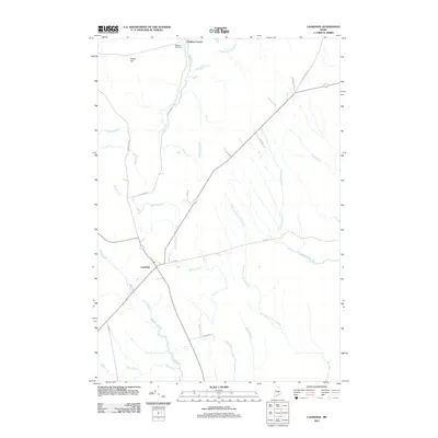
 - 1978 Map of Lagrange, 1981 Print
 1978 Lagrange1981 Print · USGSPenobscot County in the late 1970s is shown through high-altitude aerial imagery, capturing the rural landscape between settlements. Researchers can trace the layout of Lagrange and Medford Center and follow the paths of Hemlock and Birch through the woods.
 - 1978 Map of Milo South, 1981 Print
 1978 Milo South1981 Print · USGSPiscataquis County, Maine, is seen here in the late seventies as a landscape defined by its river confluences and timberlands. Genealogists and historians can trace the footprints of Milo and Derby or locate rural landmarks like Stores Corner and Boyd Lake.
 - 1978 Map of Milo North, 1981 Print
 1978 Milo North1981 Print · USGSThe shorelines of Piscataquis County appear in stark aerial detail during the late seventies, centered on the massive Schoodic Lake. Local historians can trace the lakeside settlements of Lake View and Adams or the southern river junctions near Milo.
 - 1978 Map of Hardy Pond, 1981 Print
 1978 Hardy Pond1981 Print · USGSMaine's forested interior along the Piscataquis River is captured here in the late seventies. Researchers can trace the layout of Medford and Medford Center or follow the waters of Hardy Pond and Schoodic Stream.
 - 1983 Map of Milo South, 1984 Print
 1983 Milo South1984 Print · USGSSouthern Piscataquis County in the early 1980s reveals a landscape of railroad junctions and river valleys. Genealogists and local historians can trace the B & A line through Derby or locate ancestral sites like Orneville Cem and Storers Corner.
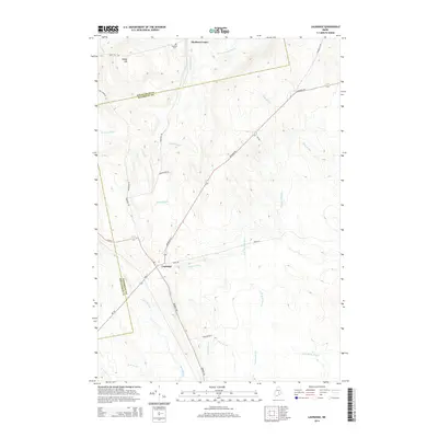
 - 1983 Map of Lagrange, 1984 Print
 1983 Lagrange1984 Print · USGSPenobscot County in the early eighties shows a landscape of timberlands and stream networks centered on the village of Lagrange. Trace the path of the Bangor and Aroostook railroad as it passes Paddy Hill and crosses Cold Stream.
 - 1985 Map of Lincoln, 1994 Print
 1985 Lincoln1994 Print · USGSPenobscot County in the mid-eighties remains a landscape of river-based commerce and sprawling timberlands connected by rail. You can trace the historic paths of the Maine Central RR and Canadian Pacific RR or locate rural sites like Enfield Station and the Winn Cem.
 - 1986 Map of Lincoln
 1986 Lincoln1986 Print · USGSMid-century Maine settlement and industry converge along the Penobscot and Piscataquis rivers during the 1980s. Researchers can trace the rail networks of the Maine Central and Bangor and Aroostook through towns like Howland and Milo.
 - 1988 Map of Milo North
 1988 Milo North1988 Print · USGSPiscataquis County's river valleys and wooded lakefronts are shown here in the late eighties, just as the landscape around Milo remained defined by its waterways. Researchers can trace the three-river confluence and find local landmarks like Knights Landing, Adams, and the Cem.
 - 1988 Map of Hardy Pond
 1988 Hardy Pond1988 Print · USGSThe Piscataquis River valley in the late 1980s reveals a landscape defined by expansive wetlands and quiet riverfront settlements. Genealogists and local historians can trace the foundations of Medford, Medford Center, and the remote village of Hardy along Hardy Pond.
 - 2011 Map of Hardy Pond, 2011 Print
 2011 Hardy Pond2011 Print · USGSCovers Medford, including Howland, Lake View Plantation, and other nearby areas
 - 2011 Map of Lagrange, 2011 Print
 2011 Lagrange2011 Print · USGSCovers Medford, including Bradford, Howland, and other nearby areas
 - 2011 Map of Milo South, 2011 Print
 2011 Milo South2011 Print · USGSCovers Medford, including Milo, Charleston, and other nearby areas
 - 2011 Map of Milo North, 2011 Print
 2011 Milo North2011 Print · USGSCovers Medford, including Milo, Brownville, and other nearby areas
 - 2014 Map of Milo North, 2014 Print
 2014 Milo North2014 Print · USGSCovers Medford, including Milo, Brownville, and other nearby areas
 - 2014 Map of Hardy Pond, 2014 Print
 2014 Hardy Pond2014 Print · USGSCovers Medford, including Howland, Lake View Plantation, and other nearby areas
 - 2014 Map of Lagrange, 2014 Print
 2014 Lagrange2014 Print · USGSCovers Medford, including Bradford, Howland, and other nearby areas
Showing maps 1-25 of 38
Top cities near Medford
- Milo historical maps
- Charleston historical maps
- Enfield historical maps
- Greenbush historical maps
- Hudson historical maps
- Bradford historical maps
See more
Top neighborhoods of Medford
Frequently asked questions
- What are the different types of historical maps available for Medford?
- What is the oldest map of Medford?
- Where can I purchase historical maps of Medford for my home or office?
- Where can I download high-res historical maps of Medford?
- Are there historical topographic maps available for Medford?
- Is there historical aerial imagery available for Medford?
- Where are historical maps of Medford sourced from?