1960s Maps of Piscataquis County, Maine
Explore 6 historic maps of Piscataquis County from the 1960s. These maps offer a rare glimpse into what life looked like during the 1960s — showing old roads, neighborhoods, homes, and landmarks that have changed or disappeared over time.
Whether you're researching your family's past, planning a metal detecting trip, or studying how Piscataquis County's landscape evolved across the 1960s, these high-resolution maps are a powerful tool for exploring the history of this region.
- Focus on a specific era: All maps on this page are from the 1960s, giving you a focused view of this time period.
- See what’s changed: Compare century-old streets, trails, and buildings to today's modern landscape using overlays and satellite layers.
- Research with precision: Use these maps for genealogy, historical research, land use analysis, or educational projects.
- View, download, or print: Maps are fully viewable online in high resolution, and can be downloaded or printed for your own records.
Start exploring Piscataquis County's history through authentic maps from the 1960s. This is your window into the past.
Piscataquis County, ME maps
(6)- 1960 Map of Presque Isle
 1960 Presque Isle1960 Print · USGSNorthern Maine during the mid-century was a land of timber, rails, and strategic airfields. Genealogists and historians can trace the growth of Presque Isle and Ashland or explore the remote northern reaches of Baxter State Park and Presque Isle AFB.3 unique versions available
 - 1960 Map of Millinocket
 1960 Millinocket1960 Print · USGSThe Maine North Woods and Penobscot River valley are captured at mid-century during the height of the paper milling era. Researchers can trace the Appalachian Trail near Mount Katardin or locate family roots in towns like Dover-Foxcroft and Milo.3 unique versions available
 - 1961 Map of Spider Lake, 1964 Print
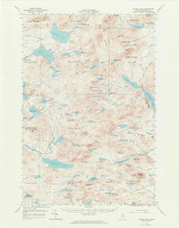 1961 Spider Lake1964 Print · USGSRemote Piscataquis County wilderness in the early 1960s reveals a landscape of fire watch towers and logging history. Trace old timber routes along the Tote Road or locate the State Forest Service Camp and Lookout Tower near Beetle Mtn.4 unique versions available
 - 1961 Map of Allagash Lake, 1964 Print
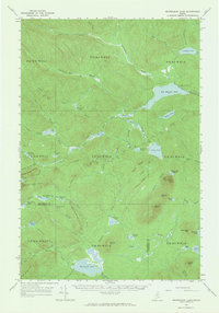
 1961 Allagash Lake1964 Print · USGSThe Maine north woods in the early sixties remain a vast network of timberlands and interconnected waterways. Researchers can trace remote logging infrastructure and forestry outposts like the Lookout Tower on Allagash Mtn and the Forest Service Camp near Allagash Lake.3 unique versions available
 - 1962 Map of Churchill Lake, 1964 Print
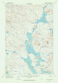 1962 Churchill Lake1964 Print · USGSMaine's North Woods in the early sixties remained a landscape of historic timber transport and remote lake systems. Researchers can trace the Old Railroad Grade and find the Tramway State Forest Service Camp and Churchill Depot.3 unique versions available
 - 1963 Map of Mooseleuk Lake, 1965 Print
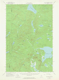
 1963 Mooseleuk Lake1965 Print · USGSThe Maine North Woods in the early sixties remained a vast timberland frontier of isolated camps and fire lookouts. Genealogists and historians can trace the remote outposts of the logging era at Shaw Camp, State Forest Service Camp, and the Horseshoe Mtn Lookout Tower.2 unique versions available
End of results
Showing maps 1-6 of 6
Top cities of Piscataquis County
- Dover-Foxcroft historical maps
- Milo historical maps
- Greenville historical maps
- Sangerville historical maps
- Guilford historical maps
- Brownville historical maps
See more
Frequently asked questions
- What are the different types of historical maps available for Piscataquis County?
- What is the oldest map of Piscataquis County?
- Where can I purchase historical maps of Piscataquis County for my home or office?
- Where can I download high-res historical maps of Piscataquis County?
- Are there historical topographic maps available for Piscataquis County?
- Is there historical aerial imagery available for Piscataquis County?
- Where are historical maps of Piscataquis County sourced from?