1940s Maps of Piscataquis County, Maine
Explore 8 historic maps of Piscataquis County from the 1940s. These maps offer a rare glimpse into what life looked like during the 1940s — showing old roads, neighborhoods, homes, and landmarks that have changed or disappeared over time.
Whether you're researching your family's past, planning a metal detecting trip, or studying how Piscataquis County's landscape evolved across the 1940s, these high-resolution maps are a powerful tool for exploring the history of this region.
- Focus on a specific era: All maps on this page are from the 1940s, giving you a focused view of this time period.
- See what’s changed: Compare century-old streets, trails, and buildings to today's modern landscape using overlays and satellite layers.
- Research with precision: Use these maps for genealogy, historical research, land use analysis, or educational projects.
- View, download, or print: Maps are fully viewable online in high resolution, and can be downloaded or printed for your own records.
Start exploring Piscataquis County's history through authentic maps from the 1940s. This is your window into the past.
Piscataquis County, ME maps
(8)- 1940 Map of Sebec
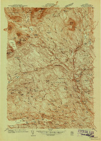 1940 Sebec1940 Print · USGSPiscataquis County in the early 1940s is captured here at a crossroads of the iron and timber industries. Researchers can locate the Katahdin Iron Works, trace the rail yards at Brownville Junction, and find rural schools like Williamsburg Sch.4 unique versions available
 - 1943 Map of Sebec
 1943 Sebec1943 Print · USGSPiscataquis County in the early 1940s is a landscape of iron works, timber rails, and remote schools. Genealogists and historians can trace the paths of the CANADIAN PACIFIC railroad and locate sites like the Williamsburg Sch, Katahdin Iron Works, and Barnard Corner.4 unique versions available
 - 1944 Map of Brassua Lake
 1944 Brassua Lake1944 Print · USGSCentral Maine was a landscape of remote sporting camps and logging rail lines in the mid-1940s. Genealogists and historians can trace old homesteads and landmarks like Somerset Junction, Blaine Sch, and Cornish Farm.
 - 1944 Map of Moosehead Lake
 1944 Moosehead Lake1944 Print · USGSThe heart of Maine's lake country is captured here during the mid-forties, showing the vital rail and water routes of the North Woods. Genealogists and historians can trace the Canadian Pacific line, the remote Masterman Sch, and early settlements like Rockwood.
 - 1947 Map of Schoodic, 1956 Print
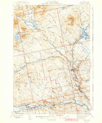
 1947 Schoodic1956 Print · USGSPiscataquis County in the late 1940s is shown here as a landscape of timber, rail, and isolated lake settlements. Genealogists and historians can trace old homesteads and landmarks like Evergreen Cem, the Maxfield Sch, and the rail stops at Packards or Lake View.3 unique versions available
 - 1948 Map of Kingsbury, 1953 Print
 1948 Kingsbury1953 Print · USGSCentral Maine's high country is captured here just after the war, showing the rural intersections of Piscataquis and Somerset Counties. Genealogists and historians can trace the family-named crossroads of Mayfield Corner, Hutchins Corner, and Moody Corner, alongside the Campbell Sch.3 unique versions available
 - 1949 Map of Schoodic
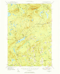
 1949 Schoodic1949 Print · USGSThe rail-and-river network of central Maine is captured here just after the war, showing the junction of two major rail lines. Genealogists and historians can trace old community sites like Lake View, Knights Landing, and the Maxfield Sch.2 unique versions available
 - 1949 Map of Katahdin, 1955 Print
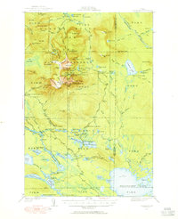 1949 Katahdin1955 Print · USGSThe Maine North Woods in the late 1940s centers on the rise of Baxter State Park and the towering peak of Mount Katahdin. Researchers can trace early backcountry infrastructure like Joe Francis Camp, the Tote Road, and the original Abol Campsite.10 unique versions available
End of results
Showing maps 1-8 of 8
Top cities of Piscataquis County
- Dover-Foxcroft historical maps
- Milo historical maps
- Greenville historical maps
- Sangerville historical maps
- Guilford historical maps
- Brownville historical maps
See more
Frequently asked questions
- What are the different types of historical maps available for Piscataquis County?
- What is the oldest map of Piscataquis County?
- Where can I purchase historical maps of Piscataquis County for my home or office?
- Where can I download high-res historical maps of Piscataquis County?
- Are there historical topographic maps available for Piscataquis County?
- Is there historical aerial imagery available for Piscataquis County?
- Where are historical maps of Piscataquis County sourced from?