1900s (20th Century) Maps of Baywalker Village, Maryland
Explore 10 historic maps of Baywalker Village from the 1900s (20th Century). These maps offer a rare glimpse into what life looked like during the 1900s — showing old roads, neighborhoods, homes, and landmarks that have changed or disappeared over time.
Whether you're researching your family's past, planning a metal detecting trip, or studying how Baywalker Village's landscape evolved across the 1900s, these high-resolution maps are a powerful tool for exploring the history of this region.
- Focus on a specific era: All maps on this page are from the 1900s, giving you a focused view of this time period.
- See what’s changed: Compare century-old streets, trails, and buildings to today's modern landscape using overlays and satellite layers.
- Research with precision: Use these maps for genealogy, historical research, land use analysis, or educational projects.
- View, download, or print: Maps are fully viewable online in high resolution, and can be downloaded or printed for your own records.
Start exploring Baywalker Village's history through authentic maps from the 1900s. This is your window into the past.
Baywalker Village, MD maps
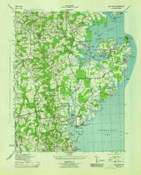
(10)- 1905 Map of Owensville
 1905 Owensville1905 Print · USGSCoastal Maryland in the early twentieth century was a landscape of tide-water wharves and rural post offices. Genealogists can trace family connections through sites like Owensville West River PO, Hartges Wharf, and Mitchellville PO.5 unique versions available
 - 1906 Map of Patuxent
 1906 Patuxent1906 Print · USGSThe Tidewater region of Maryland and the outskirts of the District of Columbia are shown here at the turn of the century. Researchers can trace the early footprints of Maryland Agril. College, find riverfront infrastructure at Milltown Landing, and follow long-established routes like the Marlboro Turnpike.4 unique versions available
 - 1944 Map of West River
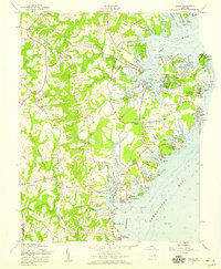
 1944 West River1944 Print · USGSCoastal Anne Arundel County comes alive during the war years, showing a landscape of maritime industry and rural crossroads. Genealogists can trace family roots through Tracys Landing, the Franklin Ch and Cem, and schools like Nutwell Sch.
 - 1948 Map of Washington
 1948 Washington1948 Print · USGSThe Potomac and Chesapeake regions in the late 1940s reveal a landscape of expanding military reach and deep-rooted Tidewater settlements. Trace old rail corridors like the Richmond Fredericksburg & Potomac RR or locate landmarks like the Wakefield Washington Monument and St. Marys College.2 unique versions available
 - 1957 Map of Deale, 1959 Print
 1957 Deale1959 Print · USGSCoastal Maryland at the dawn of the 1960s reveals a blend of historic river landings and new waterfront developments. Genealogists and local historians can locate legacy sites like St James Ch alongside seasonal destinations such as Camp Wabanna and Mimosa Cove.4 unique versions available
 - 1957 Map of Washington, 1966 Print
 1957 Washington1966 Print · USGSThe mid-Atlantic region during the mid-fifties and early sixties reveals a landscape of growing suburbs and vital military outposts. Researchers can trace historic river towns and shorelines from Alexandria to the Hooper Islands and St Clements Island.5 unique versions available
 - 1961 Map of Washington
 1961 Washington1961 Print · USGSThe mid-Atlantic region in the late fifties is presented in remarkable detail, from the Blue Ridge foothills to the Chesapeake Eastern Shore. Researchers can trace historic river landings and military sites like Mount Vernon, Fort Belvoir, and Point Lookout.2 unique versions available
 - 1983 Map of Washington East, 1984 Print
 1983 Washington East1984 Print · USGSThe Chesapeake Bay region in the early eighties shows the Maryland capital and its suburbs meeting the maritime traditions of the Eastern Shore. Researchers can trace land patterns from Andrews Air Force Base to waterfront settlements like Oxford and Chesapeake Beach.2 unique versions available
 - 1989 Map of Washington
 1989 Washington1989 Print · USGSThe Potomac River valley and Chesapeake Bay are shown in comprehensive detail during the late 1980s. Genealogists and historians can trace the transition from urban Alexandria to the rural Northern Neck, locating landmarks like Mount Vernon and Stratford Hall.
 - 1997 Map of Deale, 1999 Print
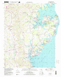 1997 Deale1999 Print · USGSThe western shore of the Chesapeake Bay comes alive in this late-century look at Maryland's tidal creeks and maritime communities. Genealogists and local historians can trace family locations through Galesville, Deale, and Shady Side, or find historic landmarks like West River Church and Deep Creek Airpark.
End of results
Showing maps 1-10 of 10
Top cities near Baywalker Village
- Bowie historical maps
- Annapolis historical maps
- Mitchellville historical maps
- Marlboro Village historical maps
- Marlton historical maps
- Edgewater historical maps
See more
Frequently asked questions
- What are the different types of historical maps available for Baywalker Village?
- What is the oldest map of Baywalker Village?
- Where can I purchase historical maps of Baywalker Village for my home or office?
- Where can I download high-res historical maps of Baywalker Village?
- Are there historical topographic maps available for Baywalker Village?
- Is there historical aerial imagery available for Baywalker Village?
- Where are historical maps of Baywalker Village sourced from?