1950s Maps of Fishing Creek Farms, Maryland
Explore 3 historic maps of Fishing Creek Farms from the 1950s. These maps offer a rare glimpse into what life looked like during the 1950s — showing old roads, neighborhoods, homes, and landmarks that have changed or disappeared over time.
Whether you're researching your family's past, planning a metal detecting trip, or studying how Fishing Creek Farms's landscape evolved across the 1950s, these high-resolution maps are a powerful tool for exploring the history of this region.
- Focus on a specific era: All maps on this page are from the 1950s, giving you a focused view of this time period.
- See what’s changed: Compare century-old streets, trails, and buildings to today's modern landscape using overlays and satellite layers.
- Research with precision: Use these maps for genealogy, historical research, land use analysis, or educational projects.
- View, download, or print: Maps are fully viewable online in high resolution, and can be downloaded or printed for your own records.
Start exploring Fishing Creek Farms's history through authentic maps from the 1950s. This is your window into the past.
Fishing Creek Farms, MD maps
(3)- 1953 Map of Annapolis
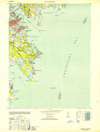 1953 Annapolis1953 Print · USGSThe Annapolis waterfront during the early 1950s shows a dense landscape of naval facilities and coastal settlements. Genealogists and historians can trace the development of Eastport, Arundel on the Bay, and the historic U S Naval Academy.
 - 1957 Map of Annapolis, 1958 Print
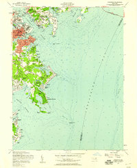 1957 Annapolis1958 Print · USGSMid-century Annapolis and its surrounding peninsula are captured here as suburban growth begins to reach the Chesapeake shoreline. Researchers can trace the layout of the U S Naval Academy, find local landmarks like St Marys Church, or locate vanished leisure spots like Carrs Beach.5 unique versions available
 - 1957 Map of Washington, 1966 Print
 1957 Washington1966 Print · USGSThe mid-Atlantic region during the mid-fifties and early sixties reveals a landscape of growing suburbs and vital military outposts. Researchers can trace historic river towns and shorelines from Alexandria to the Hooper Islands and St Clements Island.5 unique versions available
End of results
Showing maps 1-3 of 3
Top cities near Fishing Creek Farms
- Bowie historical maps
- Severna Park historical maps
- Annapolis historical maps
- Crofton historical maps
- Pasadena historical maps
- Arnold historical maps
See more
Frequently asked questions
- What are the different types of historical maps available for Fishing Creek Farms?
- What is the oldest map of Fishing Creek Farms?
- Where can I purchase historical maps of Fishing Creek Farms for my home or office?
- Where can I download high-res historical maps of Fishing Creek Farms?
- Are there historical topographic maps available for Fishing Creek Farms?
- Is there historical aerial imagery available for Fishing Creek Farms?
- Where are historical maps of Fishing Creek Farms sourced from?