1900s (20th Century) Maps of Rossville, Maryland
Explore 15 historic maps of Rossville from the 1900s (20th Century). These maps offer a rare glimpse into what life looked like during the 1900s — showing old roads, neighborhoods, homes, and landmarks that have changed or disappeared over time.
Whether you're researching your family's past, planning a metal detecting trip, or studying how Rossville's landscape evolved across the 1900s, these high-resolution maps are a powerful tool for exploring the history of this region.
- Focus on a specific era: All maps on this page are from the 1900s, giving you a focused view of this time period.
- See what’s changed: Compare century-old streets, trails, and buildings to today's modern landscape using overlays and satellite layers.
- Research with precision: Use these maps for genealogy, historical research, land use analysis, or educational projects.
- View, download, or print: Maps are fully viewable online in high resolution, and can be downloaded or printed for your own records.
Start exploring Rossville's history through authentic maps from the 1900s. This is your window into the past.
Rossville, MD maps
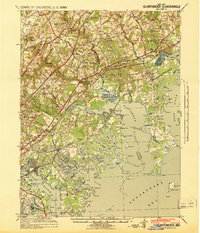
(15)- 1901 Map of Gunpowder
 1901 Gunpowder1901 Print · USGSCoastal Baltimore and Harford Counties are captured here at the turn of the century as the Chesapeake shoreline met a growing rail network. Genealogists and historians can trace old homesteads and landings near Abingdon, Joppa, and the Battle Monument.7 unique versions available
 - 1903 Map of Tolchester
 1903 Tolchester1903 Print · USGSThe upper Chesapeake Bay at the turn of the century shows a bustling maritime landscape where steamship wharves and major rail lines met. Researchers can trace defunct stops like Baldwin Sta. and Clayton Sta. or locate historic landings such as Rockhall Landing and Quaker Wharf.
 - 1908 Map of Tolchester
 1908 Tolchester1908 Print · USGSChesapeake Bay life at the turn of the century centered on a complex network of tidewater landings and strategic railroad lines. Researchers can trace historic family settlements and maritime landmarks like Fort Howard, Harford Furnace, and the Sevenfoot Knoll LH.4 unique versions available
 - 1941 Map of Gunpowder
 1941 Gunpowder1941 Print · USGSThe Chesapeake tidewater and the Gunpowder River valley are caught in their pre-war rural state in this early 1940s survey. Researchers can trace the paths of the P.R.R. System and locate historic sites like Harford Furnace and Osbornes Ruins.
 - 1948 Map of Baltimore
 1948 Baltimore1948 Print · USGSMaryland and Pennsylvania crossroads are captured in the late 1940s, showing a landscape defined by historic rail lines and major military installations. Genealogists can trace family connections in Gettysburg, Westminster, and near the U.S. Naval Academy in Annapolis.2 unique versions available
 - 1949 Map of Gunpowder, 1955 Print
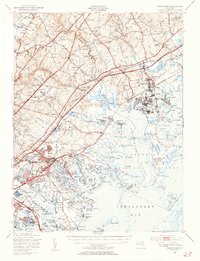 1949 Gunpowder1955 Print · USGSThe upper Chesapeake Bay shorelines of Baltimore and Harford counties are seen here in the late 1940s, marked by heavy rail and growing military installations. Researchers can find coastal landmarks like Stansbury Manor, the historic McComas Institute, and the sprawling Army Chemical Center.2 unique versions available
 - 1951 Map of Middle River
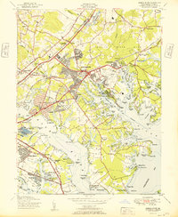 1951 Middle River1951 Print · USGSCoastal Baltimore County comes alive in the early fifties, showing a landscape shaped by military aviation and suburban growth. Trace the history of Middle River and Essex through landmarks like the Essex Seaplane Base, Diffendalls Airfield, and the North Point Battlefield Monument.
 - 1954 Map of Baltimore
 1954 Baltimore1954 Print · USGSThe Mid-Atlantic region in the early fifties shows a landscape of growing suburban centers and heavy rail corridors. Trace mid-century transit networks and military landmarks from the Aberdeen Proving Ground to the Gettysburg National Military Park.
 - 1956 Map of Baltimore
 1956 Baltimore1956 Print · USGSMid-century Maryland and Pennsylvania are captured here during a period of massive suburban and military growth across the Chesapeake region. Genealogists and historians can trace the rail corridors of the Baltimore & Ohio RR and locate landmarks like Fort McHenry or the Aberdeen Proving Ground.
 - 1957 Map of Baltimore, 1964 Print
 1957 Baltimore1964 Print · USGSMaryland and Southern Pennsylvania are shown during the mid-century expansion of the Baltimore-Washington corridor. Researchers can trace the extensive rail lines of the Baltimore & Ohio RR and locate sites like Fort Detrick and Gettysburg National Military Park.5 unique versions available
 - 1961 Map of Baltimore
 1961 Baltimore1961 Print · USGSMaryland and Pennsylvania are captured at a mid-century peak of industrial and military expansion. Genealogists and historians can trace rail corridors like the Western Maryland Ry or locate regional landmarks such as Camp Detrick and Kent Island.
 - 1969 Map of Middle River, 1971 Print
 1969 Middle River1971 Print · USGSCoastal Baltimore County is captured in a moment of rapid postwar growth, centered on the aviation and rail hubs of the Middle River area. Researchers can trace the layout of early suburbs like Victory Villa and Essex or locate landmarks such as the Battle Monument and Martin Airport.4 unique versions available
 - 1984 Map of Baltimore
 1984 Baltimore1984 Print · USGSThe Baltimore and Annapolis corridor in the mid-eighties shows a landscape of rapid suburban growth and deep-seated maritime history. Researchers can trace the massive footprints of the U S Naval Academy, Fort George G Meade, and Goddard Space Flight Ctr.
 - 1989 Map of Baltimore
 1989 Baltimore1989 Print · USGSThe Mid-Atlantic corridor in the late eighties is captured here, from the Baltimore harbor to the Blue Ridge foothills. Researchers can trace the sprawling footprints of Aberdeen Proving Ground, the historic grounds of Gettysburg National Military Park, and the winding Susquehanna River.
 - 1998 Map of Middle River, 2000 Print
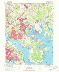
 1998 Middle River2000 Print · USGSThe Middle River shoreline and Baltimore's eastern suburbs are captured here in the late 1990s, showcasing a landscape defined by aviation and coastal development. Genealogists and historians can trace neighborhood growth through Aero Acres or locate landmarks like the Battle Monument and Martin State Airport.
End of results
Showing maps 1-15 of 15
Top cities near Rossville
- Baltimore historical maps
- Glen Burnie historical maps
- Dundalk historical maps
- Towson historical maps
- Towson historical maps
- Essex historical maps
See more
Frequently asked questions
- What are the different types of historical maps available for Rossville?
- What is the oldest map of Rossville?
- Where can I purchase historical maps of Rossville for my home or office?
- Where can I download high-res historical maps of Rossville?
- Are there historical topographic maps available for Rossville?
- Is there historical aerial imagery available for Rossville?
- Where are historical maps of Rossville sourced from?