Old Maps of Governor Run, Calvert County
Explore 33 old maps of Governor Run, spanning from 1892 to today. These high-resolution historic maps reveal how streets, neighborhoods, landmarks, and natural features evolved over time — perfect for genealogy, metal detecting, research, and local history exploration.
What you can do with these maps:
- See how Governor Run changed over time: Compare historical maps to modern-day views to trace roads, homesites, rail lines & more.
- View detailed metadata: Each map includes creators, publishers, year, scale, and archive source.
- Overlay maps with satellite & LiDAR: Visualize the past alongside modern tools to explore terrain & human change.
- Trusted historical sources: Maps sourced from the USGS, Library of Congress, and other archives.
- Access maps your way: View online, download high-res files, or order prints for personal or research use.
Start exploring old maps of Governor Run to uncover forgotten places, hidden landmarks, and the deep history beneath your feet.
Governor Run, Calvert County maps
(33)- 1892 Map of Leonardtown
 1892 Leonardtown1892 Print · USGSSt. Mary's County at the end of the nineteenth century was a world of river wharves and tobacco landings. Trace the path of the Proposed Drum Point R.R. and locate family landmarks like Sotterly or Reeder Wharf along the Patuxent River.
 - 1892 Map of Prince Frederick
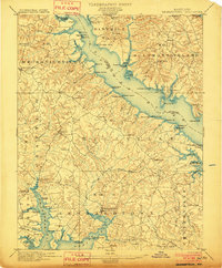
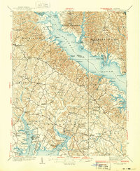
 1892 Prince Frederick1892 Print · USGSCalvert County at the end of the Victorian era is captured here as a landscape of tobacco landings and emerging rail. Researchers can trace the Drum Point Railroad Proposed or locate old water-access points like Magruder Ferry and Leitches Wharf.
 - 1895 Map of Prince Frederick
 1895 Prince Frederick1895 Print · USGSMaryland's tobacco country and river-bound peninsulas are captured in the late nineteenth century before modern bridges spanned the waters. You can trace the path of the Drum Point Proposed R. R. or locate historic river landings like Magruder Ferry and Leitches Wharf.
 - 1895 Map of Leonardtown
 1895 Leonardtown1895 Print · USGSSouthern Maryland in the 1890s is captured here as a river-centric landscape of wharves and crossroads. Researchers can trace the early maritime economy through landings like Reeder Wharf and Forest Wharf, or locate family sites in Hollywood and Leonardtown.
 - 1895 Map of Nomini
 1895 Nomini1895 Print · USGSSouthern Maryland and the Virginia tidewater shores meet along the Potomac in this late nineteenth-century survey. Genealogists can trace family holdings and river landings from Charlotte Hall down to Sotterly and the Nomini Ferry.
 - 1898 Map of Nomini
 1898 Nomini1898 Print · USGSMaryland and Virginia's Tidewater region comes alive in the late nineteenth century as a world of river landings, rail terminals, and rural crossroads. Researchers can trace the maritime economy through Nomini Ferry and Stone Wharf, or locate ancestral homesteads near Charlotte Hall and Potomac Mills.5 unique versions available
 - 1899 Map of Patuxent
 1899 Patuxent1899 Print · USGSSouthern Maryland in the late nineteenth century was a world of river wharves and emerging rail lines. Genealogists can trace family names across landings and settlements like Bladensburg, Upper Marlboro, and Piscataway Reform School before the landscape was modernised.3 unique versions available
 - 1901 Map of Prince Frederick
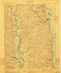
 1901 Prince Frederick1901 Print · USGSThe Tidewater region of Maryland is captured here at the dawn of the twentieth century, when river travel and steamship wharves still defined the local economy. Researchers can locate vanished landings and ferry crossings like Magruder Ferry, Leitch Wharf, and Lower Marlboro.
 - 1901 Map of Leonardtown
 1901 Leonardtown1901 Print · USGSMaryland's tidewater country at the turn of the century is defined by its deep reliance on the river and bay. Genealogists and historians can trace the vital maritime economy through old landings and wharves like Sotterly Wharf, Abells Wharf, and Coburns Wharf.3 unique versions available
 - 1906 Map of Patuxent
 1906 Patuxent1906 Print · USGSThe Tidewater region of Maryland and the outskirts of the District of Columbia are shown here at the turn of the century. Researchers can trace the early footprints of Maryland Agril. College, find riverfront infrastructure at Milltown Landing, and follow long-established routes like the Marlboro Turnpike.4 unique versions available
 - 1910 Map of Prince Frederick
 1910 Prince Frederick1910 Print · USGSCoastal Calvert County comes alive in the early twentieth century, showing a landscape defined by the Patuxent River and the bay. Genealogists can trace old wharves and family settlements from Lower Marlboro to the Chesapeake Beach RR line.3 unique versions available
 - 1936 Map of Leonardtown
 1936 Leonardtown1936 Print · USGSSt. Mary's County wharves and rural parishes are captured in detail during the mid-1930s. Genealogists can trace family footprints at Old All Faith Ch, identify old school sites like Maryland Springs Sch, or locate historic landings such as Williams Wharf.
 - 1938 Map of Prince Frederick
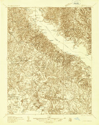
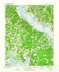
 1938 Prince Frederick1938 Print · USGSCalvert County at the height of the 1930s reveals a Maryland landscape defined by tobacco farming and bay-front resorts. Researchers can locate vanished rural landmarks like the Cedar Hill Sch, explore the wharves at Deep Landing, or trace the early layout of Chesapeake Beach.3 unique versions available
 - 1939 Map of Leonardtown
 1939 Leonardtown1939 Print · USGSSouthern Maryland's river-oriented landscape is captured here in the late 1930s, centered on the community of Leonardtown. Genealogists can trace family roots through numerous country schools and landmarks like Bannaker Sch, St Andrews Ch, and the many landings along the Patuxent River.3 unique versions available
 - 1948 Map of Washington
 1948 Washington1948 Print · USGSThe Potomac and Chesapeake regions in the late 1940s reveal a landscape of expanding military reach and deep-rooted Tidewater settlements. Trace old rail corridors like the Richmond Fredericksburg & Potomac RR or locate landmarks like the Wakefield Washington Monument and St. Marys College.2 unique versions available
 - 1950 Map of Leonardtown, 1964 Print
 1950 Leonardtown1964 Print · USGSMid-century Southern Maryland comes alive on this peninsula bounded by the Patuxent and Potomac estuaries. Genealogists and historians can trace family-named points and rural infrastructure through landmarks like St Andrews Ch, Williams Wharf, and Broomes Island.
 - 1953 Map of Prince Frederick, 1956 Print
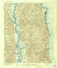
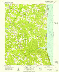 1953 Prince Frederick1956 Print · USGSCalvert County at mid-century remains a landscape of ridge-top settlements and quiet coastal reaches between the river and bay. Genealogists can locate family-named landmarks and rural congregations like St Pauls Cem, Emmanuel Ch, and the coastal cabins at Scientists Cliffs.4 unique versions available
 - 1957 Map of Washington, 1966 Print
 1957 Washington1966 Print · USGSThe mid-Atlantic region during the mid-fifties and early sixties reveals a landscape of growing suburbs and vital military outposts. Researchers can trace historic river towns and shorelines from Alexandria to the Hooper Islands and St Clements Island.5 unique versions available
 - 1961 Map of Washington
 1961 Washington1961 Print · USGSThe mid-Atlantic region in the late fifties is presented in remarkable detail, from the Blue Ridge foothills to the Chesapeake Eastern Shore. Researchers can trace historic river landings and military sites like Mount Vernon, Fort Belvoir, and Point Lookout.2 unique versions available
 - 1963 Map of Broomes Island, 1964 Print
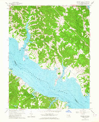 1963 Broomes Island1964 Print · USGSCoastal Calvert County in the early sixties remains a landscape of quiet river landings and rural parishes along the Patuxent. Researchers can trace historic shorelines and family sites from Sotterley to Broomes Island, including landmarks like Island Creek Sch and Parker Wharf.3 unique versions available
 - 1983 Map of Washington East, 1984 Print
 1983 Washington East1984 Print · USGSThe Chesapeake Bay region in the early eighties shows the Maryland capital and its suburbs meeting the maritime traditions of the Eastern Shore. Researchers can trace land patterns from Andrews Air Force Base to waterfront settlements like Oxford and Chesapeake Beach.2 unique versions available
 - 1983 Map of Leonardtown, 1984 Print
 1983 Leonardtown1984 Print · USGSSouthern Maryland and the Northern Neck of Virginia are shown in the early eighties as a mosaic of historic tidewater settlements and modern installations. Trace family roots and shoreline changes near St Marys City, Leonardtown, and Colonial Beach.2 unique versions available
 - 1989 Map of Washington
 1989 Washington1989 Print · USGSThe Potomac River valley and Chesapeake Bay are shown in comprehensive detail during the late 1980s. Genealogists and historians can trace the transition from urban Alexandria to the rural Northern Neck, locating landmarks like Mount Vernon and Stratford Hall.
 - 2011 Map of Broomes Island, 2011 Print
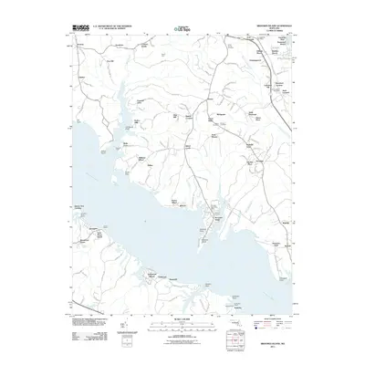 2011 Broomes Island2011 Print · USGSCovers Governor Run, including Mutual Estates, Long Cove Estates, and other nearby areas
 - 2011 Map of Prince Frederick, 2011 Print
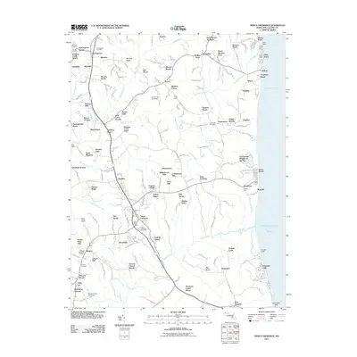 2011 Prince Frederick2011 Print · USGSCovers Governor Run, including Prince Frederick, Bess-Mar Estates, and other nearby areas
Showing maps 1-25 of 33
Frequently asked questions
- What are the different types of historical maps available for Governor Run?
- What is the oldest map of Governor Run?
- Where can I purchase historical maps of Governor Run for my home or office?
- Where can I download high-res historical maps of Governor Run?
- Are there historical topographic maps available for Governor Run?
- Is there historical aerial imagery available for Governor Run?
- Where are historical maps of Governor Run sourced from?