1940s Maps of Westminster, Maryland
Explore 4 historic maps of Westminster from the 1940s. These maps offer a rare glimpse into what life looked like during the 1940s — showing old roads, neighborhoods, homes, and landmarks that have changed or disappeared over time.
Whether you're researching your family's past, planning a metal detecting trip, or studying how Westminster's landscape evolved across the 1940s, these high-resolution maps are a powerful tool for exploring the history of this region.
- Focus on a specific era: All maps on this page are from the 1940s, giving you a focused view of this time period.
- See what’s changed: Compare century-old streets, trails, and buildings to today's modern landscape using overlays and satellite layers.
- Research with precision: Use these maps for genealogy, historical research, land use analysis, or educational projects.
- View, download, or print: Maps are fully viewable online in high resolution, and can be downloaded or printed for your own records.
Start exploring Westminster's history through authentic maps from the 1940s. This is your window into the past.
Westminster, MD maps
(4)- 1942 Map of Gettysburg, 1944 Print
 1942 Gettysburg1944 Print · USGSGettysburg and its surrounding borderlands are shown in great detail during the early 1940s, capturing the region's dense network of rural schools and mills. Genealogists can trace family-named landmarks such as Galt Kump PO, Hafers Mill, and Philips Delight Sch.
 - 1944 Map of New Windsor
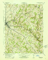
 1944 New Windsor1944 Print · USGSMid-century Carroll County comes into focus as a landscape of academic institutions, milling operations, and rolling ridges. Genealogists and local historians can trace family-named sites like Wagners Mill, the John Hyde Quarry, and settlements from Uniontown to Warfieldsburg.2 unique versions available
 - 1944 Map of Westminster
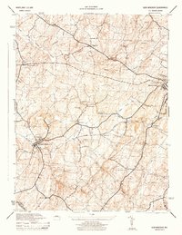
 1944 Westminster1944 Print · USGSCarroll County was a landscape of rail-connected trade and small church hamlets during the mid-1940s. Genealogists can trace family roots through rural communities like Snydersburg and Houcksville or locate old landmarks such as Wesley Chapel and Cranberry Station.
 - 1948 Map of Baltimore
 1948 Baltimore1948 Print · USGSMaryland and Pennsylvania crossroads are captured in the late 1940s, showing a landscape defined by historic rail lines and major military installations. Genealogists can trace family connections in Gettysburg, Westminster, and near the U.S. Naval Academy in Annapolis.2 unique versions available
End of results
Showing maps 1-4 of 4
Top cities near Westminster
- Randallstown historical maps
- Owings Mills historical maps
- Eldersburg historical maps
- Reisterstown historical maps
- Hanover historical maps
- Parkville historical maps
See more
Top neighborhoods of Westminster
- Middle Brooke historical maps
- Wakefield Valley historical maps
- Avondale Ridge historical maps
- Avondale Run historical maps
- Belle Grove Square historical maps
- Carroll Lutheran Village historical maps
See more
Frequently asked questions
- What are the different types of historical maps available for Westminster?
- What is the oldest map of Westminster?
- Where can I purchase historical maps of Westminster for my home or office?
- Where can I download high-res historical maps of Westminster?
- Are there historical topographic maps available for Westminster?
- Is there historical aerial imagery available for Westminster?
- Where are historical maps of Westminster sourced from?