1990s Maps of Elkton, Maryland
Explore 2 historic maps of Elkton from the 1990s. These maps offer a rare glimpse into what life looked like during the 1990s — showing old roads, neighborhoods, homes, and landmarks that have changed or disappeared over time.
Whether you're researching your family's past, planning a metal detecting trip, or studying how Elkton's landscape evolved across the 1990s, these high-resolution maps are a powerful tool for exploring the history of this region.
- Focus on a specific era: All maps on this page are from the 1990s, giving you a focused view of this time period.
- See what’s changed: Compare century-old streets, trails, and buildings to today's modern landscape using overlays and satellite layers.
- Research with precision: Use these maps for genealogy, historical research, land use analysis, or educational projects.
- View, download, or print: Maps are fully viewable online in high resolution, and can be downloaded or printed for your own records.
Start exploring Elkton's history through authentic maps from the 1990s. This is your window into the past.
Elkton, MD maps
(2)- 1992 Map of Newark West, 1993 Print
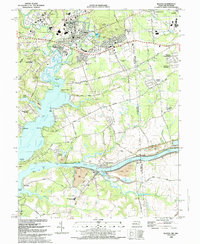
 1992 Newark West1993 Print · USGSThe borderlands of Maryland, Delaware, and Pennsylvania are shown in the early nineties, centered on the equestrian landscapes of Fair Hill. Trace family roots at the Welsh Tract Ch or locate the Fair Hill Training Center and Elk Mills.3 unique versions available
 - 1992 Map of Elkton, 1993 Print
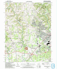
 1992 Elkton1993 Print · USGSMaryland and Delaware meet along this corridor in the early nineties as suburban expansion reaches the historic Cecil County seat. Genealogists can trace family names and sites from Gilpin Cem and Crouch Chapel to the industrial legacy of the Chesapeake and Delaware Canal.
End of results
Showing maps 1-2 of 2
Top cities near Elkton
- Newark historical maps
- Hockessin historical maps
- New Garden Township historical maps
- Middletown historical maps
- Kennett Square historical maps
- Elsmere historical maps
See more
Top neighborhoods of Elkton
- Buckhill Farms historical maps
- Delancy Village historical maps
- Elkton Heights historical maps
- Elkton Landing historical maps
- Gilpin Manor historical maps
- Heritage Valley historical maps
See more
Frequently asked questions
- What are the different types of historical maps available for Elkton?
- What is the oldest map of Elkton?
- Where can I purchase historical maps of Elkton for my home or office?
- Where can I download high-res historical maps of Elkton?
- Are there historical topographic maps available for Elkton?
- Is there historical aerial imagery available for Elkton?
- Where are historical maps of Elkton sourced from?