Old Maps of Myersville, Maryland
Explore 32 old maps of Myersville, spanning from 1884 to today. These high-resolution historic maps reveal how streets, neighborhoods, landmarks, and natural features evolved over time — perfect for genealogy, metal detecting, research, and local history exploration.
What you can do with these maps:
- See how Myersville changed over time: Compare historical maps to modern-day views to trace roads, homesites, rail lines & more.
- View detailed metadata: Each map includes creators, publishers, year, scale, and archive source.
- Overlay maps with satellite & LiDAR: Visualize the past alongside modern tools to explore terrain & human change.
- Trusted historical sources: Maps sourced from the USGS, Library of Congress, and other archives.
- Access maps your way: View online, download high-res files, or order prints for personal or research use.
Start exploring old maps of Myersville to uncover forgotten places, hidden landmarks, and the deep history beneath your feet.
Myersville, MD maps
(32)- 1884 Map of Harpers Ferry
 1884 Harpers Ferry1884 Print · USGSThe confluence of the Potomac and Shenandoah rivers is captured in the mid-1880s, documenting a landscape of strategic gaps and vital transit corridors. Researchers can trace the path of the Chesapeake and Ohio Canal and locate historic river crossings like Conrad Ferry and Castleman Ferry.
 - 1891 Map of Harpers Ferry
 1891 Harpers Ferry1891 Print · USGSThe tri-state borderlands of the Potomac and Shenandoah valleys were a vital hub of transport and trade in the late 1800s. Researchers can trace historic river crossings like Castlemans Ferry, follow the route of the Chesapeake and Ohio Canal, or locate family-named settlements like Oatlands and Taylorstown.
 - 1893 Map of Harpers Ferry, 1898 Print
 1893 Harpers Ferry1898 Print · USGSThe tri-state region of the Potomac and Shenandoah valleys is captured here in the late nineteenth century, showing a landscape defined by water and rail. Trace the historic Chesapeake and Ohio Canal or locate local landmarks like Snyder Mills and Harpers Ferry.7 unique versions available
 - 1908 Map of Middletown
 1908 Middletown1908 Print · USGSThe Potomac River valley in the early twentieth century shows a landscape defined by the convergence of major rail lines and the historic Chesapeake and Ohio Canal. Genealogists and historians can trace the foundations of Eakles Mills, Burkittsville, and Washington Junction.
 - 1909 Map of Hagerstown
 1909 Hagerstown1909 Print · USGSHagerstown and the Antietam valley appear here during the height of the steam rail era, shortly after the turn of the century. Genealogists and historians can locate family homesteads near landmarks like St James Church, Smoketown School, and the Hagerstown and Boonsboro Ry.
 - 1910 Map of Antietam
 1910 Antietam1910 Print · USGSMaryland's borderlands and the Potomac River valley are captured here in the early twentieth century. Genealogists can locate family landmarks like Garretts Mill, trace the Chesapeake and Ohio Canal, or find historic sites including Dunkard Church.6 unique versions available
 - 1912 Map of Hagerstown
 1912 Hagerstown1912 Print · USGSMaryland's Cumberland Valley flourished as a rail and milling corridor during the early twentieth century. Genealogists can trace family names across dozens of rural landmarks like Strites Mill, Hallowell Church, and the Paradise School.9 unique versions available
 - 1942 Map of Hagerstown
 1942 Hagerstown1942 Print · USGSThe Cumberland Valley and Potomac corridor are captured here at the height of the Second World War rail-and-river era. Genealogists and historians can trace the industrial landscape of Richmond Furnace, the route of the Chesapeake and Ohio Canal, and the grounds of Camp Ritchie.
 - 1943 Map of Hagerstown
 1943 Hagerstown1943 Print · USGSThe Cumberland Valley was a critical wartime logistics hub in the 1940s, teeming with rail traffic and new military installations. Genealogists and historians can trace the Chesapeake and Ohio Canal or locate local landmarks like Richmond Furnace and Camp Ritchie.
 - 1944 Map of Middletown
 1944 Middletown1944 Print · USGSMaryland's Middletown Valley during the mid-forties reveals a rural landscape of crossroads hamlets and prominent ridge-line monuments. Researchers can locate family-named settlements like Zittlestown and Frostown or trace mountain landmarks from Fox Gap to the Catoctin Mountain range.2 unique versions available
 - 1944 Map of Myersville
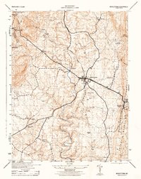
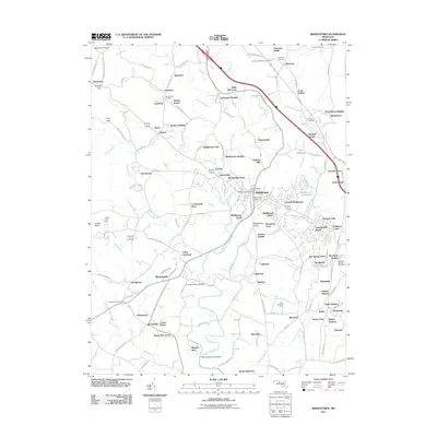
 1944 Myersville1944 Print · USGSMaryland's mountain gaps and valley settlements are captured here during the mid-forties, showing the rural landscape of Frederick and Washington counties. Researchers can locate the Black Rock Hotel (Ruins), the hilltop Church Hill, and small hamlets like Wolfsville and Jugtown.
 - 1948 Map of Baltimore
 1948 Baltimore1948 Print · USGSMaryland and Pennsylvania crossroads are captured in the late 1940s, showing a landscape defined by historic rail lines and major military installations. Genealogists can trace family connections in Gettysburg, Westminster, and near the U.S. Naval Academy in Annapolis.2 unique versions available
 - 1953 Map of Myersville, 1954 Print
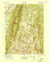
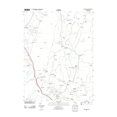
 1953 Myersville1954 Print · USGSThe Frederick and Washington County line follows the crest of the Blue Ridge in the early fifties, where the Appalachian Trail winds past Annapolis Rock. Genealogists and historians can locate rural homesteads near Wolfsville Crossing, St Marks Ch, and Jerusalem.6 unique versions available
 - 1953 Map of Middletown, 1954 Print
 1953 Middletown1954 Print · USGSMaryland's Middletown Valley is shown here in the early fifties, caught between the parallel ridges of South and Catoctin Mountains. Genealogists and hikers can trace the Appalachian Trail past the Reno Monument or locate family roots near Burkittsville and Pleasant View Ch.6 unique versions available
 - 1954 Map of Baltimore
 1954 Baltimore1954 Print · USGSThe Mid-Atlantic region in the early fifties shows a landscape of growing suburban centers and heavy rail corridors. Trace mid-century transit networks and military landmarks from the Aberdeen Proving Ground to the Gettysburg National Military Park.
 - 1956 Map of Baltimore
 1956 Baltimore1956 Print · USGSMid-century Maryland and Pennsylvania are captured here during a period of massive suburban and military growth across the Chesapeake region. Genealogists and historians can trace the rail corridors of the Baltimore & Ohio RR and locate landmarks like Fort McHenry or the Aberdeen Proving Ground.
 - 1957 Map of Baltimore, 1964 Print
 1957 Baltimore1964 Print · USGSMaryland and Southern Pennsylvania are shown during the mid-century expansion of the Baltimore-Washington corridor. Researchers can trace the extensive rail lines of the Baltimore & Ohio RR and locate sites like Fort Detrick and Gettysburg National Military Park.5 unique versions available
 - 1961 Map of Baltimore
 1961 Baltimore1961 Print · USGSMaryland and Pennsylvania are captured at a mid-century peak of industrial and military expansion. Genealogists and historians can trace rail corridors like the Western Maryland Ry or locate regional landmarks such as Camp Detrick and Kent Island.
 - 1983 Map of Hagerstown, 1984 Print
 1983 Hagerstown1984 Print · USGSThe tri-state borderlands of Maryland, Pennsylvania, and West Virginia are shown in the early eighties as a hub of military installations and valley towns. Genealogists and historians can trace the landscape from Gettysburg National Military Park to the banks of the Potomac River.2 unique versions available
 - 1984 Map of Frederick, 1985 Print
 1984 Frederick1985 Print · USGSMaryland's Piedmont and the Potomac River valley are shown here in the mid-eighties as suburban growth began to meet historic rural landscapes. Genealogists and historians can trace the paths of the Baltimore and Ohio RR or locate the boundaries of Antietam National Battlefield and Fort Detrick.
 - 1989 Map of Baltimore
 1989 Baltimore1989 Print · USGSThe Mid-Atlantic corridor in the late eighties is captured here, from the Baltimore harbor to the Blue Ridge foothills. Researchers can trace the sprawling footprints of Aberdeen Proving Ground, the historic grounds of Gettysburg National Military Park, and the winding Susquehanna River.
 - 1994 Map of Myersville, 1999 Print
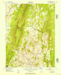
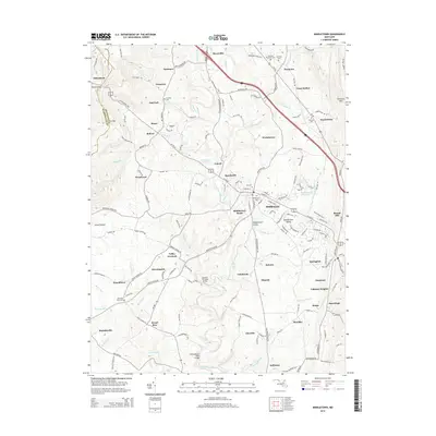
 1994 Myersville1999 Print · USGSMaryland's Blue Ridge highlands are captured here in the 1990s, where South Mountain divides the rural valleys. Researchers can trace the layout of Wolfsville, Jerusalem, and Mount Aetna Academy among the ridges and state park lands.
 - 2011 Map of Middletown, 2011 Print
 2011 Middletown2011 Print · USGSCovers Myersville, including Middletown, Braddock Heights, and other nearby areas
 - 2011 Map of Myersville, 2011 Print
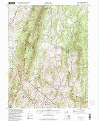
 2011 Myersville2011 Print · USGSCovers Myersville, including Mount Aetna, Highfields, and other nearby areas
 - 2014 Map of Middletown, 2014 Print
 2014 Middletown2014 Print · USGSCovers Myersville, including Middletown, Braddock Heights, and other nearby areas
Showing maps 1-25 of 32
Top cities near Myersville
- Frederick historical maps
- Hagerstown historical maps
- Ballenger Creek historical maps
- Halfway historical maps
- Urbana historical maps
- Robinwood historical maps
See more
Top neighborhoods of Myersville
Frequently asked questions
- What are the different types of historical maps available for Myersville?
- What is the oldest map of Myersville?
- Where can I purchase historical maps of Myersville for my home or office?
- Where can I download high-res historical maps of Myersville?
- Are there historical topographic maps available for Myersville?
- Is there historical aerial imagery available for Myersville?
- Where are historical maps of Myersville sourced from?