1940s Maps of Lake Ford, Maryland
Explore 3 historic maps of Lake Ford from the 1940s. These maps offer a rare glimpse into what life looked like during the 1940s — showing old roads, neighborhoods, homes, and landmarks that have changed or disappeared over time.
Whether you're researching your family's past, planning a metal detecting trip, or studying how Lake Ford's landscape evolved across the 1940s, these high-resolution maps are a powerful tool for exploring the history of this region.
- Focus on a specific era: All maps on this page are from the 1940s, giving you a focused view of this time period.
- See what’s changed: Compare century-old streets, trails, and buildings to today's modern landscape using overlays and satellite layers.
- Research with precision: Use these maps for genealogy, historical research, land use analysis, or educational projects.
- View, download, or print: Maps are fully viewable online in high resolution, and can be downloaded or printed for your own records.
Start exploring Lake Ford's history through authentic maps from the 1940s. This is your window into the past.
Lake Ford, MD maps
(3)- 1947 Map of Sang Run, 1960 Print
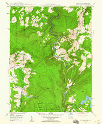 1947 Sang Run1960 Print · USGSGarrett County highlands at the end of the 1940s reveal a mountain economy transitioning from isolated farms to hydroelectric power. Genealogists can locate family-named sites like Sisler Cem, Elder Sch, and rural congregations at Pine Grove Ch.3 unique versions available
 - 1948 Map of Cumberland
 1948 Cumberland1948 Print · USGSMid-century Appalachia and the Shenandoah Valley are shown in detail, documenting the industrial and transportation hubs of the tri-state area. Genealogists can trace family roots through settlements like Double Tollgate and Bunker Hill or along the Baltimore & Ohio RR.3 unique versions available
 - 1949 Map of Sang Run
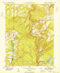 1949 Sang Run1949 Print · USGSMaryland's western highlands come to life in the late 1940s as the Youghiogheny River cuts through the forest. Genealogists and historians can trace Cranesville and Sang Run, find family-named peaks like Lewis Knob, and locate Sister Cem.
End of results
Showing maps 1-3 of 3
Top cities near Lake Ford
- Kingwood historical maps
- Mountain Lake Park historical maps
- Oakland historical maps
- Terra Alta historical maps
- Rowlesburg historical maps
- Loch Lynn Heights historical maps
See more
Frequently asked questions
- What are the different types of historical maps available for Lake Ford?
- What is the oldest map of Lake Ford?
- Where can I purchase historical maps of Lake Ford for my home or office?
- Where can I download high-res historical maps of Lake Ford?
- Are there historical topographic maps available for Lake Ford?
- Is there historical aerial imagery available for Lake Ford?
- Where are historical maps of Lake Ford sourced from?