1940s Maps of Brewster, Massachusetts
Explore 13 historic maps of Brewster from the 1940s. These maps offer a rare glimpse into what life looked like during the 1940s — showing old roads, neighborhoods, homes, and landmarks that have changed or disappeared over time.
Whether you're researching your family's past, planning a metal detecting trip, or studying how Brewster's landscape evolved across the 1940s, these high-resolution maps are a powerful tool for exploring the history of this region.
- Focus on a specific era: All maps on this page are from the 1940s, giving you a focused view of this time period.
- See what’s changed: Compare century-old streets, trails, and buildings to today's modern landscape using overlays and satellite layers.
- Research with precision: Use these maps for genealogy, historical research, land use analysis, or educational projects.
- View, download, or print: Maps are fully viewable online in high resolution, and can be downloaded or printed for your own records.
Start exploring Brewster's history through authentic maps from the 1940s. This is your window into the past.
Brewster, MA maps
(13)- 1942 Map of Cape Cod Bay
 1942 Cape Cod Bay1942 Print · USGSThe mid-Cape and Outer Cape regions are shown here during the early war years, documenting a landscape of coastal villages and maritime trade. Researchers can trace family roots through old settlements like South Truro, find the grounds of Camp Edwards, or locate historic aids like Sandy Neck Light.
 - 1942 Map of Chatham
 1942 Chatham1942 Print · USGSCoastal life on Cape Cod at the start of the 1940s centered on maritime safety and family-named waters. Researchers can trace the locations of the Chatham Lighthouse, Peoples Cem, and the long-lost Old Harbor C G Sta on the outer beach.
 - 1942 Map of Nauset, 1943 Print
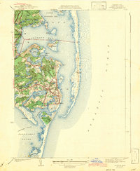
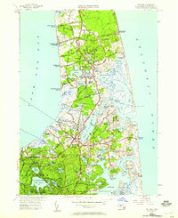
 1942 Nauset1943 Print · USGSLower Cape Cod and its maritime frontier are captured here during the early Forties, showing the vital coastal infrastructure of the era. Genealogists and historians can trace family locations and landmarks from South Wellfleet to Chatham, including Nauset Beach Light and several Life Saving Stations.
 - 1943 Map of Dennis
 1943 Dennis1943 Print · USGSMid-Cape Cod during the early war years remains a landscape of quiet coastal villages and sprawling kettle ponds. Researchers can trace the old New York New Haven and Hartford rail line to Bass River Sta or locate family plots in Howes Cem and Swan Pond Cem.3 unique versions available
 - 1943 Map of Harwich
 1943 Harwich1943 Print · USGSMid-Cape Cod in the early 1940s shows a landscape of glacial kettle ponds and coastal villages connected by the New York New Haven and Hartford RR. Genealogists can trace family names through the Dillingham Cem and Evergreen Cem or locate old school sites like Sea Pine Sch.3 unique versions available
 - 1943 Map of Chatham
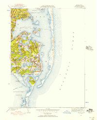
 1943 Chatham1943 Print · USGSCape Cod’s southeastern elbow is captured here during the early years of the war, showing a world of maritime navigation and coastal hamlets. You can trace family history at Peoples Cem or locate historic beacons like Chatham Lighthouse and Stage Harbor Lighthouse.3 unique versions available
 - 1944 Map of Orleans
 1944 Orleans1944 Print · USGSCoastal life on the Outer Cape is captured here during the early forties, showing the transition from traditional maritime work to early recreation. Trace the old rail line of the New York New Haven and Hartford or locate historical landmarks like the Nauset Beach Lighthouse and Evergreen Cem.3 unique versions available
 - 1946 Map of Orleans, 1958 Print
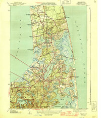
 1946 Orleans1958 Print · USGSThe Lower Cape is mapped here just after the war, showing the coastal villages of Barnstable County before modern expansion. Genealogists and historians can trace family locations near Evergreen Cemetery, the Nauset Beach Lighthouse, and historic landings like Rock Harbor.2 unique versions available
 - 1947 Map of Providence, 1948 Print
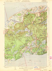
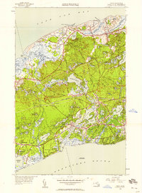
 1947 Providence1948 Print · USGSSouthern New England is captured in the mid-1940s, showing a landscape defined by busy industrial ports and expanding military installations. Researchers can trace the rail lines of the N.Y. N.H. & H. RR or locate coastal defenses like Fort Adams and Quonset Point.5 unique versions available
 - 1947 Map of Chatham, 1956 Print
 1947 Chatham1956 Print · USGSCape Cod's lower elbow appears in detail just after the war, showing the maritime and village life of this coastal community. Genealogists and historians can trace family locations near Seaside Cem or locate the Chatham C G Sta and Chatham Airport.2 unique versions available
 - 1948 Map of Providence, 1951 Print
 1948 Providence1951 Print · USGSSouthern New England’s coastal reaches are captured here in the late 1940s, from the industrial heart of Providence to the tip of Provincetown. Genealogists and historians can trace rail lines like the Central Vermont Railway and locate active military sites such as Otis Air Force Base and Fort Rodman.
 - 1949 Map of Harwich, 1957 Print
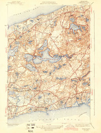
 1949 Harwich1957 Print · USGSCoastal Barnstable County comes to life in this mid-century survey, documenting the area between the bay and the sound as post-war growth began. Researchers can trace the New York New Haven and Hartford rail corridor and locate family plots in Evergreen Cem or Dillingham Grove Cem.
 - 1949 Map of Dennis, 1958 Print
 1949 Dennis1958 Print · USGSMid-century Cape Cod comes to life in this survey of the villages between the bay and the sound. Genealogists and local historians can locate the Bass River Sta, Yarmouth Cem, and early coastal settlements like New Boston.2 unique versions available
End of results
Showing maps 1-13 of 13
Top cities near Brewster
- Yarmouth historical maps
- Hyannis historical maps
- Dennis historical maps
- Harwich historical maps
- Chatham historical maps
- Orleans historical maps
See more
Top neighborhoods of Brewster
Frequently asked questions
- What are the different types of historical maps available for Brewster?
- What is the oldest map of Brewster?
- Where can I purchase historical maps of Brewster for my home or office?
- Where can I download high-res historical maps of Brewster?
- Are there historical topographic maps available for Brewster?
- Is there historical aerial imagery available for Brewster?
- Where are historical maps of Brewster sourced from?