1970s Maps of Eastham, Massachusetts
Explore 4 historic maps of Eastham from the 1970s. These maps offer a rare glimpse into what life looked like during the 1970s — showing old roads, neighborhoods, homes, and landmarks that have changed or disappeared over time.
Whether you're researching your family's past, planning a metal detecting trip, or studying how Eastham's landscape evolved across the 1970s, these high-resolution maps are a powerful tool for exploring the history of this region.
- Focus on a specific era: All maps on this page are from the 1970s, giving you a focused view of this time period.
- See what’s changed: Compare century-old streets, trails, and buildings to today's modern landscape using overlays and satellite layers.
- Research with precision: Use these maps for genealogy, historical research, land use analysis, or educational projects.
- View, download, or print: Maps are fully viewable online in high resolution, and can be downloaded or printed for your own records.
Start exploring Eastham's history through authentic maps from the 1970s. This is your window into the past.
Eastham, MA maps
(4)- 1972 Map of Wellfleet, 1974 Print
 1972 Wellfleet1974 Print · USGSThe Outer Cape's mid-century character is preserved in this 1970s survey of the Wellfleet area. Researchers can trace family-named hollows and historic sites from the Marconi Station Site to the South Wellfleet Cemetery and the Penn Central rail line.3 unique versions available
 - 1974 Map of Orleans, 1976 Print
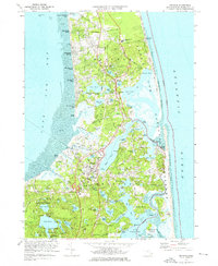 1974 Orleans1976 Print · USGSLower Cape Cod in the mid-seventies shows a landscape of protected shoreline and growing seasonal communities. Researchers can trace the legacy of the peninsula through landmarks like Nauset Light, the Penn Central rail corridor, and the grounds of Soldiers Cem.3 unique versions available
 - 1977 Map of Wellfleet, 1981 Print
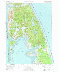
 1977 Wellfleet1981 Print · USGSThe Outer Cape in the late seventies is revealed through detailed aerial imagery of its shifting sands and tidal marshes. Researchers can trace the developed centers of Wellfleet and South Wellfleet set against the Atlantic Ocean.
 - 1977 Map of Orleans, 1981 Print
 1977 Orleans1981 Print · USGSCape Cod's outer reaches appear in striking photographic detail during the late 1970s, showcasing the interplay of water and sand. Trace coastal changes and properties across Orleans, Eastham, and the fragile sands of Nauset Beach.
End of results
Showing maps 1-4 of 4
Top cities near Eastham
- Yarmouth historical maps
- Dennis historical maps
- Harwich historical maps
- Brewster historical maps
- Chatham historical maps
- Orleans historical maps
See more
Top neighborhoods of Eastham
- Rock Harbor historical maps
- North Eastham historical maps
- Cooks Brook Beach historical maps
- Campground Landing historical maps
- Thumpertown Beach historical maps
Frequently asked questions
- What are the different types of historical maps available for Eastham?
- What is the oldest map of Eastham?
- Where can I purchase historical maps of Eastham for my home or office?
- Where can I download high-res historical maps of Eastham?
- Are there historical topographic maps available for Eastham?
- Is there historical aerial imagery available for Eastham?
- Where are historical maps of Eastham sourced from?