1800s (19th Century) Maps of Orleans, Massachusetts
Explore 8 historic maps of Orleans from the 1800s (19th Century). These maps offer a rare glimpse into what life looked like during the 1800s — showing old roads, neighborhoods, homes, and landmarks that have changed or disappeared over time.
Whether you're researching your family's past, planning a metal detecting trip, or studying how Orleans's landscape evolved across the 1800s, these high-resolution maps are a powerful tool for exploring the history of this region.
- Focus on a specific era: All maps on this page are from the 1800s, giving you a focused view of this time period.
- See what’s changed: Compare century-old streets, trails, and buildings to today's modern landscape using overlays and satellite layers.
- Research with precision: Use these maps for genealogy, historical research, land use analysis, or educational projects.
- View, download, or print: Maps are fully viewable online in high resolution, and can be downloaded or printed for your own records.
Start exploring Orleans's history through authentic maps from the 1800s. This is your window into the past.
Orleans, MA maps
(8)- 1887 Map of Wellfleet
 1887 Wellfleet1887 Print · USGSThe lower Cape comes into focus during the late nineteenth and early twentieth centuries as the railroad reshapes coastal commerce. Genealogists and historians can trace family locations near the Methodist Camp Ground, Mayo's Beach Light, and the Marconi Towers.
 - 1887 Map of Yarmouth
 1887 Yarmouth1887 Print · USGSMid-Cape Cod comes to life in the late nineteenth century as the rail network expands through established maritime villages. Genealogists can trace family footprints across South Yarmouth, West Dennis, and Harwich Port, or locate landmarks like Bass River Lt. and Scargo Hill.
 - 1888 Map of Chatham
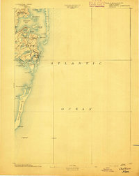
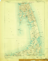
 1888 Chatham1888 Print · USGSThe Lower Cape Cod coastline appears in its late nineteenth-century form, from the settlements of Chatham and Orleans down the length of Monomoy Island. Maritime historians can trace essential safety landmarks like Chatham Lights and the Pollock Rip light ship.
 - 1889 Map of Yarmouth
 1889 Yarmouth1889 Print · USGSMid-Cape Cod comes to life in the late 1880s as the rail network reshapes the maritime landscape. Genealogists and historians can trace the early rail stops along the Old Colony Railroad and locate vanished landmarks like the Town House or the historic harbor at Dennis Port.
 - 1889 Map of Wellfleet
 1889 Wellfleet1889 Print · USGSThe Lower Cape is shown here in the late nineteenth century as a vital maritime and railroad corridor. Genealogists and historians can trace the early rail stops and shoreline landmarks like the Methodist Camp Ground and the Billingsgate Light.
 - 1893 Map of Chatham
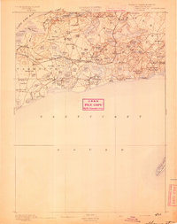
 1893 Chatham1893 Print · USGSThe outer Cape Cod coastline at the end of the nineteenth century reveals a complex maritime landscape of barrier islands and shifting shoals. Trace the old village footprints of Chatham and North Chatham alongside vital coastal aids like Chatham Lights and the Pollock Rip Light Ship.7 unique versions available
 - 1893 Map of Yarmouth
 1893 Yarmouth1893 Print · USGSMid-Cape Cod in the late nineteenth century is a landscape of thriving maritime villages and a busy rail network. Trace nineteenth-century family roots across Old Colony Railroad depots and through settlements like South Yarmouth, Dennis Port, and West Brewster.7 unique versions available
 - 1893 Map of Wellfleet
 1893 Wellfleet1893 Print · USGSCape Cod's outer reaches are shown in the late 1800s, when the Old Colony Railroad served isolated fishing villages and lifesaving stations. Trace historic sites like the Methodist Camp Ground, Billingsgate Light, and early schools at Schoolhouse Pond.8 unique versions available
End of results
Showing maps 1-8 of 8
Top cities near Orleans
- Yarmouth historical maps
- Dennis historical maps
- Harwich historical maps
- Brewster historical maps
- Chatham historical maps
- Eastham historical maps
See more
Top neighborhoods of Orleans
- Nauset Heights historical maps
- Tonset historical maps
- Weeset historical maps
- East Orleans historical maps
- South Orleans historical maps
- Namskaket historical maps
Frequently asked questions
- What are the different types of historical maps available for Orleans?
- What is the oldest map of Orleans?
- Where can I purchase historical maps of Orleans for my home or office?
- Where can I download high-res historical maps of Orleans?
- Are there historical topographic maps available for Orleans?
- Is there historical aerial imagery available for Orleans?
- Where are historical maps of Orleans sourced from?