Old Maps of Maple Grove, Adams
Explore 25 old maps of Maple Grove, spanning from 1886 to today. These high-resolution historic maps reveal how streets, neighborhoods, landmarks, and natural features evolved over time — perfect for genealogy, metal detecting, research, and local history exploration.
What you can do with these maps:
- See how Maple Grove changed over time: Compare historical maps to modern-day views to trace roads, homesites, rail lines & more.
- View detailed metadata: Each map includes creators, publishers, year, scale, and archive source.
- Overlay maps with satellite & LiDAR: Visualize the past alongside modern tools to explore terrain & human change.
- Trusted historical sources: Maps sourced from the USGS, Library of Congress, and other archives.
- Access maps your way: View online, download high-res files, or order prints for personal or research use.
Start exploring old maps of Maple Grove to uncover forgotten places, hidden landmarks, and the deep history beneath your feet.
Maple Grove, Adams maps
(25)- 1886 Map of Greylock
 1886 Greylock1886 Print · USGSThe northern Berkshires are captured here in the mid-1880s, dominated by the massif of Mt Greylock and the industrial valleys below. Genealogists and researchers can trace the vital rail links through the Hoosac Tunnel Line and find old neighborhood names like Blackington, Cheshire Harbor, and Savoy Hollow.
 - 1891 Map of Greylock
 1891 Greylock1891 Print · USGSThe northern Berkshires are captured here in the late nineteenth century as rail lines and textile centers transformed the rugged valley floor. Genealogists and hikers can trace old homesteads and landmarks like Mt Greylock, the Hoosac Tunnel Line, and the vanished site of Arnoldsville.
 - 1893 Map of Greylock
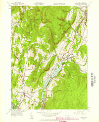
 1893 Greylock1893 Print · USGSThe Northern Berkshires were at an industrial peak in the late 1800s, centered on the vital rail and water corridors of the Hoosic Valley. Researchers can trace the engineering of the Hoosac Tunnel Line and find historic mill settlements like Maple Grove and Cheshire Harbor.
 - 1898 Map of Greylock
 1898 Greylock1898 Print · USGSThe Berkshire highlands at the close of the nineteenth century reveal a landscape of deep valleys and engineering feats. Trace the path of the Hoosac Tunnel or locate historic mill sites and rail stops in North Adams, Zylonite, and Cheshire.10 unique versions available
 - 1900 Map of Taconic
 1900 Taconic1900 Print · USGSThe tri-state border region of the Taconic Mountains thrived at the turn of the century as a hub of rail travel and valley industry. Genealogists and historians can trace the early footprints of Hoosick Falls, Bennington, and the winding path of the Rutland R.R.4 unique versions available
 - 1944 Map of Cheshire, 1958 Print
 1944 Cheshire1958 Print · USGSThe Hoosic River valley is captured here in the mid-1940s, showing a landscape defined by the Boston and Albany Railroad and upland dairy farming. Researchers can trace historic mill hamlets like Arnoldsville and Cheshire Harbor or locate the Stone Sch.2 unique versions available
 - 1946 Map of Cheshire
 1946 Cheshire1946 Print · USGSMid-century Berkshire County is captured here during the post-war era, showing the intersection of industrial rail lines and steep mountain terrain. Genealogists and historians can trace the Boston and Albany rail stops through Cheshire Harbor, Farnams, and the Stone Sch.
 - 1947 Map of Cheshire
 1947 Cheshire1947 Print · USGSBerkshire County at the end of the 1940s shows a landscape of mountain ridges and valley industry defined by the Hoosic River corridor. Researchers can trace the Boston and Albany Railroad past the Stone Sch and the waters of Cheshire Reservoir.3 unique versions available
 - 1948 Map of Albany, 1951 Print
 1948 Albany1951 Print · USGSThe Hudson and Connecticut River valleys are captured here in the late 1940s, showing the vital rail and water corridors of the Northeast. You can trace the Boston and Maine tracks past Mt Greylock or locate early settlements like Great Barrington and Bennington.
 - 1956 Map of Albany, 1968 Print
 1956 Albany1968 Print · USGSThe industrial heart of the Northeast is revealed in the mid-1950s, from the Hudson Valley to the Connecticut River. Researchers can trace the legacy of the Quabbin Reservoir, locate Westover Air Force Base, or follow the Rutland RR through the Green Mountains.2 unique versions available
 - 1957 Map of Albany
 1957 Albany1957 Print · USGSThe Tri-State region and Connecticut River Valley are captured here during a period of significant postwar growth and infrastructure expansion. Genealogists and historians can trace the rail-and-river economy through landmarks like the Boston and Maine railroad, Quabbin Reservoir, and Westover Air Force Base.
 - 1959 Map of Albany
 1959 Albany1959 Print · USGSThe Hudson and Connecticut River valleys are captured here during the late fifties, showing the region's dense rail networks and massive water projects. Researchers can trace the New York State Thruway or locate local landmarks like Mt Greylock and the Quabbin Reservoir.
 - 1959 Map of Cheshire, 1961 Print
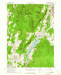 1959 Cheshire1961 Print · USGSThe Berkshires' industrial and natural landscape is captured here in the late fifties, from the peak of Mt Greylock State Reservation to the valley floor. Genealogists and hikers can trace the Appalachian Trail, locate family plots at Scott Cem, or find old industrial sites along the New York Central rail line.2 unique versions available
 - 1962 Map of Albany
 1962 Albany1962 Print · USGSThe Hudson and Connecticut River valleys meet the Green Mountains and Berkshires in this mid-century overview of the Northeast. Genealogists and historians can trace the industrial hearts of Albany and Springfield or locate features like Quabbin Reservoir and Westover Air Force Base.
 - 1973 Map of Cheshire, 1975 Print
 1973 Cheshire1975 Print · USGSThe high Berkshires meet the industrial Hoosic River valley in the early seventies, capturing a landscape of mountain trails and rail-side settlements. Researchers can trace the Appalachian Trail over Mt Greylock or locate ancestral sites like the Riverside Cem and Talcott Sch.2 unique versions available
 - 1975 Map of Cheshire, 1981 Print
 1975 Cheshire1981 Print · USGSBerkshire County at the midpoint of the 1970s reveals a landscape of concentrated valley towns and wooded ridges. Trace the boundaries of Cheshire and Adams or locate lakeside landmarks near Cheshire Reservoir and Pontoosuc Lake.
 - 1986 Map of Albany
 1986 Albany1986 Print · USGSThe Capital District and the tri-state highlands come into focus during the mid-eighties as urban growth meets the edge of the Green Mountains. Researchers can trace historic industrial sites and landmarks like the Watervliet Arsenal, the Bennington Battle Monument, and the grounds of Rensselaer Polytechnic Institute.
 - 1988 Map of Cheshire
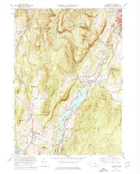
 1988 Cheshire1988 Print · USGSBerkshire County at the end of the 1980s reveals a landscape defined by industrial river valleys and preserved mountain ridges. Genealogists and hikers can trace the Appalachian National Scenic Trail past Memorial Tower or locate historic sites like Riverside Cem and St Stanislaus Sch.2 unique versions available
 - 1989 Map of Albany
 1989 Albany1989 Print · USGSThe tri-state intersection of New York, Vermont, and Massachusetts comes alive in the late 1980s, centered on the historic river confluence of the Capital District. Researchers can trace the extensive rail lines of the D & H RR and explore high peaks like Mount Greylock or the reaches of the Tomhannock Reservoir.2 unique versions available
 - 1998 Map of Cheshire, 2000 Print
 1998 Cheshire2000 Print · USGSThe Northern Berkshires come into focus in the late 1990s, where traditional valley settlements meet the rising peaks of the Hoosac Range. Genealogists and hikers can trace the Appalachian Trail past historic sites like Riverside Cem and St Stanislaus Kostka Cem.
 - 2012 Map of Cheshire, 2012 Print
 2012 Cheshire2012 Print · USGSCovers Maple Grove, including Adams, Dalton, and other nearby areas
 - 2015 Map of Cheshire, 2015 Print
 2015 Cheshire2015 Print · USGSCovers Maple Grove, including Adams, Dalton, and other nearby areas
 - 2018 Map of Cheshire, 2018 Print
 2018 Cheshire2018 Print · USGSCovers Maple Grove, including Adams, Dalton, and other nearby areas
 - 2021 Map of Cheshire, 2021 Print
 2021 Cheshire2021 Print · USGSCovers Maple Grove, including Adams, Dalton, and other nearby areas
 - 2024 Map of Cheshire, 2024 Print
 2024 Cheshire2024 Print · USGSBerkshire County at the edge of the Greylock Range is showcased here in the contemporary era. Researchers can trace family sites near Riverside Cem and Lanesborough, or follow the path of the Ashuwillticook Rail Trl through Cheshire.
End of results
Showing maps 1-25 of 25
Top cities near Maple Grove
- Pittsfield historical maps
- North Adams historical maps
- Bennington historical maps
- Adams historical maps
- Williamstown historical maps
- Hoosick historical maps
See more
Frequently asked questions
- What are the different types of historical maps available for Maple Grove?
- What is the oldest map of Maple Grove?
- Where can I purchase historical maps of Maple Grove for my home or office?
- Where can I download high-res historical maps of Maple Grove?
- Are there historical topographic maps available for Maple Grove?
- Is there historical aerial imagery available for Maple Grove?
- Where are historical maps of Maple Grove sourced from?