1970s Maps of Hancock, Massachusetts
Explore 8 historic maps of Hancock from the 1970s. These maps offer a rare glimpse into what life looked like during the 1970s — showing old roads, neighborhoods, homes, and landmarks that have changed or disappeared over time.
Whether you're researching your family's past, planning a metal detecting trip, or studying how Hancock's landscape evolved across the 1970s, these high-resolution maps are a powerful tool for exploring the history of this region.
- Focus on a specific era: All maps on this page are from the 1970s, giving you a focused view of this time period.
- See what’s changed: Compare century-old streets, trails, and buildings to today's modern landscape using overlays and satellite layers.
- Research with precision: Use these maps for genealogy, historical research, land use analysis, or educational projects.
- View, download, or print: Maps are fully viewable online in high resolution, and can be downloaded or printed for your own records.
Start exploring Hancock's history through authentic maps from the 1970s. This is your window into the past.
Hancock, MA maps
(8)- 1973 Map of Canaan, 1975 Print
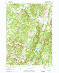 1973 Canaan1975 Print · USGSThe Taconic Range borderlands in the early seventies feature a mix of racing culture and historic valley settlements. Trace the grounds of the Lebanon Valley Speedway or locate family sites at the Cemetery of the Evergreens and Canaan Center.4 unique versions available
 - 1973 Map of Pittsfield West, 1975 Print
 1973 Pittsfield West1975 Print · USGSThe Berkshires meet the Taconic Range in the 1970s as urban growth pushes west into the mountains. Genealogists and local historians can trace the foundations of Shaker Village, locate St Josephs Cemetery, and find old camps like Camp Marion White.4 unique versions available
 - 1973 Map of Hancock, 1975 Print
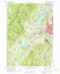
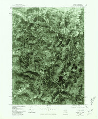
 1973 Hancock1975 Print · USGSThe Massachusetts-New York borderlands in the early 1970s feature a blend of deep-rooted valley settlements and developing alpine recreation. Researchers can trace the path of the Old Railroad Grade or locate historic sites like Hancock Central Sch and St Josephs Cem.3 unique versions available
 - 1973 Map of Berlin, 1975 Print
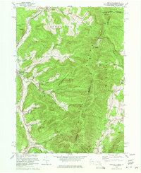 1973 Berlin1975 Print · USGSRensselaer County’s eastern border comes to life in the early 1970s as small valley towns sit beneath the high peaks of the Taconic Range. Genealogists and local historians can trace family-named sites like Moses Cem, Browns Cem, and the various hollows of Petersburg and Berlin.4 unique versions available
 - 1975 Map of Berlin, 1981 Print
 1975 Berlin1981 Print · USGSThe Rensselaer County highlands are captured in detail in the mid-1970s, showing the agricultural patterns and valley settlements of the Taconic region. Local historians can trace the development of Berlin and Petersburg along the Little Hoosic River.
 - 1975 Map of Canaan, 1981 Print
 1975 Canaan1981 Print · USGSEastern Columbia County comes into focus in the mid-1970s through this detailed aerial orthophotomap. Researchers can trace the development of Canaan and New Lebanon, or locate rural homesteads near Queechy Lake and Flatbrook.
 - 1975 Map of Hancock, 1981 Print
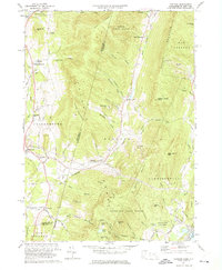
 1975 Hancock1981 Print · USGSThe Berkshires meet the New York state line in the mid-seventies, showing a landscape of high ridges and narrow farm valleys. Researchers can trace the rural layouts of Hancock and Stephentown or locate landmarks like Brodie Mountain.
 - 1975 Map of Pittsfield West, 1981 Print
 1975 Pittsfield West1981 Print · USGSThe Berkshires in the mid-seventies reveal a landscape of growing urban centers and preserved rural enclaves. Researchers can trace the development of Pittsfield or locate historic footprints at Shaker Village and Stevens Corner.
End of results
Showing maps 1-8 of 8
Top cities near Hancock
- Pittsfield historical maps
- North Adams historical maps
- Brunswick historical maps
- Sand Lake historical maps
- Adams historical maps
- Williamstown historical maps
See more
Top neighborhoods of Hancock
Frequently asked questions
- What are the different types of historical maps available for Hancock?
- What is the oldest map of Hancock?
- Where can I purchase historical maps of Hancock for my home or office?
- Where can I download high-res historical maps of Hancock?
- Are there historical topographic maps available for Hancock?
- Is there historical aerial imagery available for Hancock?
- Where are historical maps of Hancock sourced from?