1970s Maps of Church Street-Cady Hill Historic District, North Adams
Explore 2 historic maps of Church Street-Cady Hill Historic District from the 1970s. These maps offer a rare glimpse into what life looked like during the 1970s — showing old roads, neighborhoods, homes, and landmarks that have changed or disappeared over time.
Whether you're researching your family's past, planning a metal detecting trip, or studying how Church Street-Cady Hill Historic District's landscape evolved across the 1970s, these high-resolution maps are a powerful tool for exploring the history of this region.
- Focus on a specific era: All maps on this page are from the 1970s, giving you a focused view of this time period.
- See what’s changed: Compare century-old streets, trails, and buildings to today's modern landscape using overlays and satellite layers.
- Research with precision: Use these maps for genealogy, historical research, land use analysis, or educational projects.
- View, download, or print: Maps are fully viewable online in high resolution, and can be downloaded or printed for your own records.
Start exploring Church Street-Cady Hill Historic District's history through authentic maps from the 1970s. This is your window into the past.
Church Street-Cady Hill Historic District, North Adams maps
(2)- 1973 Map of North Adams, 1975 Print
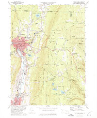 1973 North Adams1975 Print · USGSNorth Adams and its neighboring mountain townships are shown in the early seventies, a landscape where industrial valleys meet state forest peaks. Genealogists and historians can trace rail routes through the Hoosac Tunnel or locate ancestral sites like Hillside Cem and Briggsville.4 unique versions available
 - 1975 Map of North Adams, 1981 Print
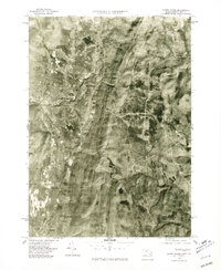 1975 North Adams1981 Print · USGSNorthern Berkshire County is documented during the mid-seventies, showing the valley floor as it transitions from industrial centers to high peaks. Researchers can trace land use patterns near North Adams, Zylonite, and the steep terrain around Whitcomb Summit.
End of results
Showing maps 1-2 of 2
Frequently asked questions
- What are the different types of historical maps available for Church Street-Cady Hill Historic District?
- What is the oldest map of Church Street-Cady Hill Historic District?
- Where can I purchase historical maps of Church Street-Cady Hill Historic District for my home or office?
- Where can I download high-res historical maps of Church Street-Cady Hill Historic District?
- Are there historical topographic maps available for Church Street-Cady Hill Historic District?
- Is there historical aerial imagery available for Church Street-Cady Hill Historic District?
- Where are historical maps of Church Street-Cady Hill Historic District sourced from?