1980s Maps of Plante-Quintairos Square, Attleboro
Explore 2 historic maps of Plante-Quintairos Square from the 1980s. These maps offer a rare glimpse into what life looked like during the 1980s — showing old roads, neighborhoods, homes, and landmarks that have changed or disappeared over time.
Whether you're researching your family's past, planning a metal detecting trip, or studying how Plante-Quintairos Square's landscape evolved across the 1980s, these high-resolution maps are a powerful tool for exploring the history of this region.
- Focus on a specific era: All maps on this page are from the 1980s, giving you a focused view of this time period.
- See what’s changed: Compare century-old streets, trails, and buildings to today's modern landscape using overlays and satellite layers.
- Research with precision: Use these maps for genealogy, historical research, land use analysis, or educational projects.
- View, download, or print: Maps are fully viewable online in high resolution, and can be downloaded or printed for your own records.
Start exploring Plante-Quintairos Square's history through authentic maps from the 1980s. This is your window into the past.
Plante-Quintairos Square, Attleboro maps
(2)- 1984 Map of Providence, 1985 Print
 1984 Providence1985 Print · USGSThe Rhode Island coast and its industrial heartlands are captured here in the mid-eighties, showing the density of the Providence metro area. Researchers can trace historic rail lines like the Providence & Worcester RR and explore the maritime layout of Narragansett Bay and Newport.
 - 1987 Map of Attleboro
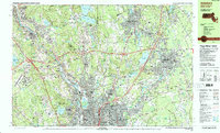 1987 Attleboro1987 Print · USGSThe Rhode Island and Massachusetts borderlands during the late eighties show a landscape of industrial river towns and post-war suburban growth. Trace family history through Saylesville Highlands or locate landmarks like the Lincoln Greyhound Park and Diamond Hill Reservoir.2 unique versions available
End of results
Showing maps 1-2 of 2
Frequently asked questions
- What are the different types of historical maps available for Plante-Quintairos Square?
- What is the oldest map of Plante-Quintairos Square?
- Where can I purchase historical maps of Plante-Quintairos Square for my home or office?
- Where can I download high-res historical maps of Plante-Quintairos Square?
- Are there historical topographic maps available for Plante-Quintairos Square?
- Is there historical aerial imagery available for Plante-Quintairos Square?
- Where are historical maps of Plante-Quintairos Square sourced from?