1960s Maps of Dartmouth, Massachusetts
Explore 5 historic maps of Dartmouth from the 1960s. These maps offer a rare glimpse into what life looked like during the 1960s — showing old roads, neighborhoods, homes, and landmarks that have changed or disappeared over time.
Whether you're researching your family's past, planning a metal detecting trip, or studying how Dartmouth's landscape evolved across the 1960s, these high-resolution maps are a powerful tool for exploring the history of this region.
- Focus on a specific era: All maps on this page are from the 1960s, giving you a focused view of this time period.
- See what’s changed: Compare century-old streets, trails, and buildings to today's modern landscape using overlays and satellite layers.
- Research with precision: Use these maps for genealogy, historical research, land use analysis, or educational projects.
- View, download, or print: Maps are fully viewable online in high resolution, and can be downloaded or printed for your own records.
Start exploring Dartmouth's history through authentic maps from the 1960s. This is your window into the past.
Dartmouth, MA maps
(5)- 1963 Map of Providence
 1963 Providence1963 Print · USGSSouthern New England's coastal and industrial heartland is captured here in the early sixties, from the Rhode Island mainland to the far reaches of the Cape. Researchers can trace mid-century growth in Providence or locate landmarks on Marthas Vineyard and Nantucket Island.
 - 1963 Map of Fall River East, 1965 Print
 1963 Fall River East1965 Print · USGSCoastal Massachusetts at the start of the 1960s reveals a landscape of industrial borders and dense forests. Researchers can trace family sites near Hixville, Westport Factory, and Beulah Corners, or locate landmarks like St Patricks Cem.
 - 1963 Map of Westport, 1965 Print
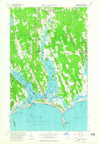 1963 Westport1965 Print · USGSThe Westport and Dartmouth coastlines come alive in the early sixties, showing a landscape of tidal flats and colonial crossroads. Genealogists and historians can trace family-named landmarks like Kirby Corner and Snell Corner, or locate the New Bedford City Rifle Range.3 unique versions available
 - 1963 Map of New Bedford South, 1965 Print
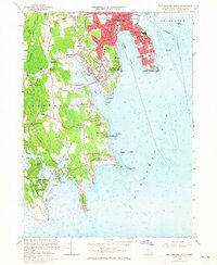 1963 New Bedford South1965 Print · USGSThe Buzzards Bay coastline in the 1960s reveals a mix of dense South Coast urbanism and rural salt marshes. Researchers can trace historic family crossroads like Wilburite Corner, coastal estates in Nonquitt, and the sprawling Fort Rodman Military Reservation.2 unique versions available
 - 1964 Map of New Bedford North, 1966 Print
 1964 New Bedford North1966 Print · USGSCoastal Massachusetts at the height of the mid-century shows the industrial heart of New Bedford and the developing residential reaches of Acushnet. Genealogists and historians can trace numerous schools and cemeteries, from Long Plain Cem to the Sacred Heart Academy.
End of results
Showing maps 1-5 of 5
Top cities near Dartmouth
- New Bedford historical maps
- Fall River historical maps
- Taunton historical maps
- Wareham historical maps
- Somerset historical maps
- Portsmouth historical maps
See more
Top neighborhoods of Dartmouth
- Shore Acres historical maps
- South Dartmouth historical maps
- Bayview historical maps
- Wilburite Corner historical maps
- Bliss Corner historical maps
- Cranberry Bog Corner historical maps
See more
Frequently asked questions
- What are the different types of historical maps available for Dartmouth?
- What is the oldest map of Dartmouth?
- Where can I purchase historical maps of Dartmouth for my home or office?
- Where can I download high-res historical maps of Dartmouth?
- Are there historical topographic maps available for Dartmouth?
- Is there historical aerial imagery available for Dartmouth?
- Where are historical maps of Dartmouth sourced from?