1970s Maps of Norton, Massachusetts
Explore 7 historic maps of Norton from the 1970s. These maps offer a rare glimpse into what life looked like during the 1970s — showing old roads, neighborhoods, homes, and landmarks that have changed or disappeared over time.
Whether you're researching your family's past, planning a metal detecting trip, or studying how Norton's landscape evolved across the 1970s, these high-resolution maps are a powerful tool for exploring the history of this region.
- Focus on a specific era: All maps on this page are from the 1970s, giving you a focused view of this time period.
- See what’s changed: Compare century-old streets, trails, and buildings to today's modern landscape using overlays and satellite layers.
- Research with precision: Use these maps for genealogy, historical research, land use analysis, or educational projects.
- View, download, or print: Maps are fully viewable online in high resolution, and can be downloaded or printed for your own records.
Start exploring Norton's history through authentic maps from the 1970s. This is your window into the past.
Norton, MA maps
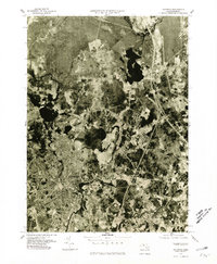
(7)- 1977 Map of Attleboro, 1981 Print
 1977 Attleboro1981 Print · USGSThe industrial and residential landscape of the Massachusetts-Rhode Island border is seen here in the late seventies. Researchers can trace the development of North Attleboro and Attleboro along the path of the Ten Mile River.
 - 1977 Map of Taunton, 1981 Print
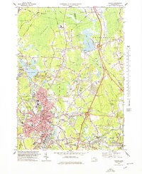
 1977 Taunton1981 Print · USGSThe Bristol County landscape in the late seventies is shown in photographic detail, capturing the dense street patterns and suburban growth around the Taunton River. Researchers can trace the layout of Taunton and Raynham Center or locate properties near the shores of Lake Nippenicket.
 - 1977 Map of Norton, 1981 Print
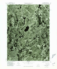
 1977 Norton1981 Print · USGSBristol County during the late seventies is revealed through detailed aerial imagery, showing the expansion of local settlements. Researchers can trace the exact 1977 footprints of Norton, West Mansfield, and the banks of Norton Reservoir.
 - 1977 Map of Mansfield, 1981 Print
 1977 Mansfield1981 Print · USGSIn the late 1970s, the South Shore region was balancing suburban growth with its dense woodlands and waterways. Study the exact 1977 footprints of Mansfield and Sharon, or trace the banks of Massapoag Lake and the Canoe River.
 - 1978 Map of Taunton, 1979 Print
 1978 Taunton1979 Print · USGSTaunton and Raynham are caught in a moment of late twentieth-century growth, balanced against the expansive Hockomock and Titicut Swamps. Genealogists and local historians can trace family locations near Mayflower Hill Cemetery, explore the industrial rail legacy of Whittenton Junction, or locate the many neighborhood schools like Leonard Sch and Mulcahey Sch.
 - 1979 Map of Taunton
 1979 Taunton1979 Print · USGSSoutheastern Massachusetts in the late seventies reveals a landscape of industrial river towns and sprawling state institutions. Local historians can trace the development of Taunton and its neighboring villages, locating sites like Wheaton College, Raynham Racetrack, and the Mayflower Hill Cem.
 - 1979 Map of Providence
 1979 Providence1979 Print · USGSRhode Island's urban heart and the Blackstone Valley are shown in detail during the late seventies, as modern interstates began to redefine the historic landscape. Genealogists and researchers can trace lineage through the North Burial Ground, the Lippitt Estate, or landmarks like the Sabin Pt Lighthouse.
End of results
Showing maps 1-7 of 7
Top cities near Norton
- Providence historical maps
- Brockton historical maps
- New Bedford historical maps
- Fall River historical maps
- Warwick historical maps
- Cranston historical maps
See more
Top neighborhoods of Norton
- Cranes Station historical maps
- East Norton historical maps
- Winnecunnet historical maps
- Centre Mills historical maps
- Chartley historical maps
- Copper Works historical maps
See more
Frequently asked questions
- What are the different types of historical maps available for Norton?
- What is the oldest map of Norton?
- Where can I purchase historical maps of Norton for my home or office?
- Where can I download high-res historical maps of Norton?
- Are there historical topographic maps available for Norton?
- Is there historical aerial imagery available for Norton?
- Where are historical maps of Norton sourced from?